Record flood can be traced to summer and fall rains
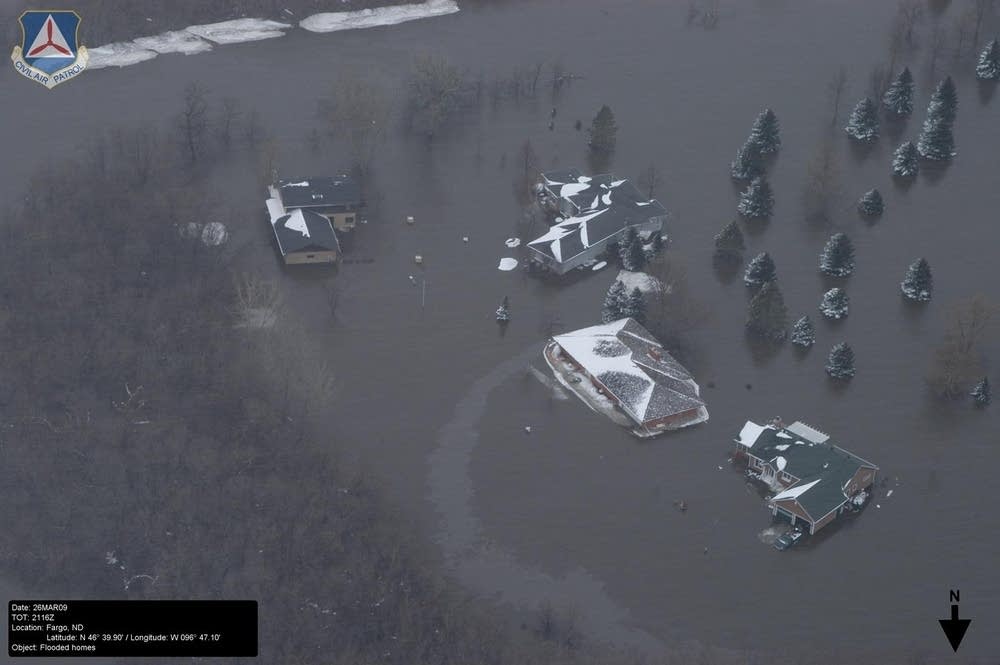
If you're standing on the edge of the Red River these days and wondering where all that water came from, think back to last summer.
In North Dakota, it may have been one of the wettest Augusts in 250 years, with more than twice the precipitation than average. Almost four inches of rain fell the second week of August in Fargo alone.
And it kept up. Five inches fell in September, and another four and a half inches in October. To make matters worse, a freak rainstorm swept through the area in November.

Steve Buan, a coordinating hydrologist with the National Weather Service in Chanhassen, which is also the home of the River Forecast Center, charts river levels around the Upper Midwest.
Create a More Connected Minnesota
MPR News is your trusted resource for the news you need. With your support, MPR News brings accessible, courageous journalism and authentic conversation to everyone - free of paywalls and barriers. Your gift makes a difference.
He walked us through what happened.
"What we saw was that our soil moisture accounting models were basically brim full, showing a saturated soil condition at freeze-up," Buan said.
That happened the second week of December, when the temperature fell by about 50 degrees from the start to the middle of the month.
The landscape froze, like a big, wet sponge, locking the moisture in place. By midwinter, U.S. Geological Survey crews were seeing the signs of trouble coming.
"What we saw this winter were extremely high flows in all the tributary rivers that were feeding into the Red," Buan said. "Some of them had record high flows, all winter long. And that indicates that the soil profile was full. It could not take any more."
The Red River Valley is amazingly flat, making it difficult to figure out exactly where the river will end up when if floods.
On February 23, Buan and another hydrologist hit the road, meeting with dozens of officials that Monday and Tuesday and telling them that serious flooding was heading for the Red River Valley, although they weren't exactly sure how much.
Buan had worked on the forecast for the 1997 floods and everyone remembered the 10 feet of snow that fell that winter. The snow was a very visual cue.
But it's the water you don't see matters, Buan told people this spring.
"When it comes to total amounts of moisture, this winter, this fall and winter far exceeds the 1996-1997 period for total amounts of moisture," he said.
Hydrologists measure river flow in cubic feet per second, which Buan says can be compared to the size of a basketball.
"So if you hear them saying 30,000 cubic feet per second going through Fargo, visualize about 30,000 basketballs per second going by," said Buan.
It's easy enough to measure how much rain falls, and see that volume of water coming. But what's tougher to calculate is how deep the water will get, and how far it will spread.

In geographic terms, the Red River Valley is amazingly flat, and it makes it very difficult to figure out exactly where the river will end up for any given amount of water.
"Nature likes a gradient, likes a fairly high gradient. It likes several feet per mile to push water down, and the Red River Valley is about one foot per mile. So there's a lot of complicating factors, what we call multidimensional flow," Buan said.
In layman's terms, that means in the Red River Valley, water likes to go sideways.
So when the water reaches record volumes and history is no longer a guide, forecasters have to put aside the maps and start converting the amount of water, known as discharge, into the depth of water at any given spot, known as a stage.
"What you're describing there is what we call hydraulic analysis, which uses a lot of mathematics, calculus, differential equations -- things that are very hard even for the college graduate to comprehend," said Buan.
"That has to take into account what we call all the hydraulic characteristics. That would be the channel roughness, how many objects are in the river channel, or the floodway as the water is going through, how many bridges are in there, any other objects that are in the channel, ice, things like that."
Forecasters started on that homework about two weeks ago as the weather warmed up. They came up with their initial estimates for how deep the river would get, somewhere in the upper 30-foot range, as measured in Fargo.
And as they zeroed in on their forecast last weekend, clouds gathered and the target started moving.
Almost three inches of precipitation fell in four days, as rain and snow. Then temperatures plunged. That meant more water. More ice. More places for the water to go, maybe more trees in the water and more bridges in the way.
"That makes all these analyses much more difficult," Buan said.
When the numbers were finally crunched, the best estimate came out Thursday night. The estimate only moved up a couple of feet, a mathematically small proportion to the overall depth of the river.
But in Fargo these days, every inch matters.
