Last year's Pagami Creek blaze part of trend of worsening fires

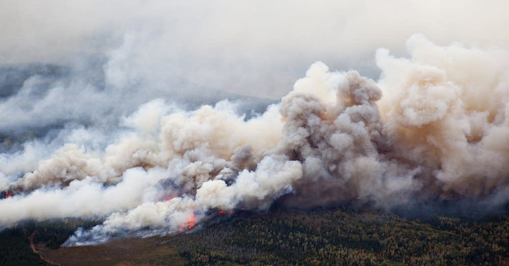
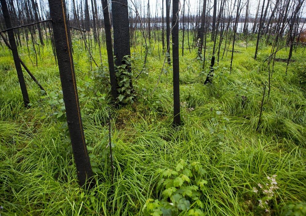
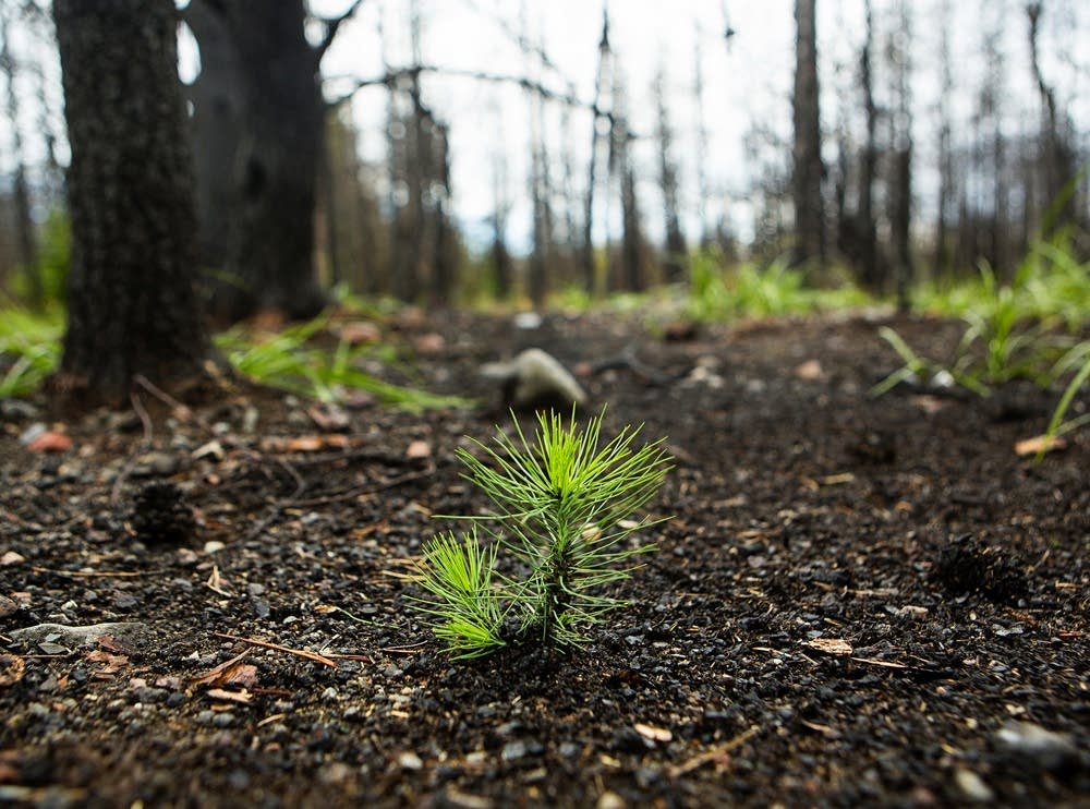
A year ago, the Pagami Creek fire roared across the Boundary Waters, engulfing 90,000 acres of forest in a single day. Signs of the devastation that occurred in the Boundary Waters Canoe Area are still present, as many dead trees remain, stripped of foliage and charred black.
"Ahead of the fire you would have seen a lot of smoke, very dark smoke...and then flames coming across the treetops," said Kris Reichenbach, public affairs officer for the Superior National Forest.
The inferno's speed across the treetops caught everyone by surprise. Several firefighters who believed they were miles ahead of the blaze were nearly incinerated when the fire overran them.
"That 10-mile run was never seen before in Minnesota," said Ellen Bogardus-Szymaniak, a fire and fuels specialist for the U.S. Forest Service. "It was like you turned on a blower into your fireplace and just had it blow up the chimney, and that's what happened."
Create a More Connected Minnesota
MPR News is your trusted resource for the news you need. With your support, MPR News brings accessible, courageous journalism and authentic conversation to everyone - free of paywalls and barriers. Your gift makes a difference.
But the potential for another such fire isn't remote. That blaze was part of a nationwide pattern of bigger, more extreme wildfires, a trend that is expected to continue nationwide and in Minnesota.
Bogardus-Szymaniak was part of a team that reviewed the agency's handling of the fire, especially the controversial initial decision to let the fire burn rather than immediately extinguish it. No one died in the fire, and only one outbuilding was lost.
The reviews eventually supported the agency's actions. But the battle to contain the fire cost $22 million and forced the evacuation of residents from an area north of the town of Isabella.
Pagami Creek is just one example of the Forest Service struggling to respond to a new era of larger, more destructive forest fires. Nationally the six biggest fire seasons since 1960 have all occurred in the past nine years.
The likelihood for such fires is growing, said Tim Sexton, director of the forest service's Wildland Fire Decision Support Center and research development applications program.
"There are a number of forests that are expected to have even more severe fire seasons this coming decade because of some of the climate change factors that are coming into play," he said. "The Superior is one of those forests that likely will experience larger, more devastating fires in the coming decade."
Sexton said two major factors are at play. First is the Smokey Bear era. For decades the Forest Service quickly extinguished every fire that ignited. That's led to dense, aging forests with an ever-growing buildup of fuel.
The second is longer fire seasons, said Steve Running, a forest ecologist and wildfire expert at the University of Montana. They result from earlier snowmelt in the spring, and warmer temperatures late into the fall.
"You put those together and it just loads the dice a little bit more for more ignitions, and more uncontrollable fire behavior when they get going," Running said.
Forest Service fire managers say that uncontrollable behavior is forcing them to be more cautious.
Tim Sexton, who last year was a district ranger for the Superior National Forest during the Pagami Creek Fire, said after it was over officials "agreed that we would have extra margins of safety to account for growth like what we saw last September 12th."
They're closing areas that might be in harm's way more quickly, and not putting firefighters or rangers in front of a moving fire.
That's already played out this year. Last week, the Superior National Forest closed several lakes in the Boundary Waters because of a small but potentially dangerous fire.
The Forest Service is also putting out fires more quickly this year, even in uninhabited wilderness areas. That's because the nation's firefighting resources are stretched thin by extremely large fires in the west.
In Ely, Superior National Forest Acting District Ranger Carl Skustad stresses that the Pagami Creek fire's dramatic expansion had nothing to do with the changes.
"It's actually driven by a national budget and policy that has us putting out fires to contain costs," Skustad said.
The move has been praised by some in Ely and Isabella who were critical of the Forest Service's handling of the Pagami Creek fire.
With several fires in the region so far this year, Ely Mayor Roger Skraba calls the new approach "a good PR move." Skraba, who is also a summertime canoe guide, said a lot of residents have complained the Forest Service didn't snuff out the Pagami Creek fire when it first flared.
"On one side, the public is saying, 'Hey, what are you doing?' " Skraba said. "On the other side, the science says, let it go. Because I can tell you from experience in the woods, fire is needed."
Balancing those competing interests will likely only get more difficult in the next several years, as fires continue to get bigger and more difficult to control.
This map provides a color-coded display of the Pagami Creek fire's spread over time. The legend at the lower right shows the date represented by each color in this format:yyyymmdd; 20110912, for example, refers to 9/12/2011, the day the fire engulfed nearly 90,000 acres.


