Climate Cast: Did climate change play role in 2012 extreme weather?
Every Thursday, MPR meteorologist Paul Huttner joins The Daily Circuit to talk about the latest research on our changing climate and the consequences that we're seeing here in Minnesota and worldwide.
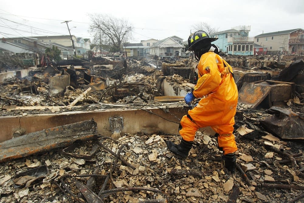
This week on Climate Cast, we discussed the role climate change may have played in Hurricane Sandy and the drought, and looked at some of the most extreme Minnesota weather events in 2012.
Here is an edited transcript of the conversation:
Kerri Miller: I'm going to play a little tape here to remind you of what we're talking about today and one of the events that was high on everyone's list.
Create a More Connected Minnesota
MPR News is your trusted resource for the news you need. With your support, MPR News brings accessible, courageous journalism and authentic conversation to everyone - free of paywalls and barriers. Your gift makes a difference.
AUDIO: That's a wind gust right there.The tide has been rising. Is that snow or rain? It's rain but it's coming down really hard. We're seeing waves six feet high.
Miller: Paul, that reminds me of how chaotic that was. Like a brew of crazy weather.
Paul Huttner: It was just amazing and frightening to watch this thing come. It was a slow motion weather disaster that we saw coming a week in advance. Some of the computer models, the hurricane center, did a great job seeing the potential path of the storm a week in advance. And then it was just a question of watching it come ashore and when it did. It exceeded everyone's expectations.
Miller: Is it the damage that Hurricane Sandy did that puts it at the top of extreme weather lists? What kind of standard are they using?
Huttner: That's the biggest one and let's start with that.
Sandy hit the most populated region in the United States with devastating damage. And I think overall it really altered the conversation about climate change. Some of the numbers: New York and New Jersey some of the hardest hit - 125 killed, 43 in NYC alone, 8 million without power, $100 billion in damage - and that's second only to Katrina. This may end up being the second most devastating hurricane to hit the United States.
Miller: When you say it altered the conversation is that because we got an up close real time look at what a changing climate can mean to a storm and the kind of damage it can do in a place where you maybe might not expect it?
• MPR News Primer: Climate change
Huttner: Let's talk about the links specifically and how climate change might have played a role in Sandy. Again, it's not a slam dunk but there are some strong ties here as we try to connect the dots between how a changing climate is driving extreme weather patterns.
First of all, Kerri, the water temperatures, the sea surface temperatures off of the Atlantic coast in October were unusually warm unusually far north. That was a result of the very hot summer that we saw in the northern hemisphere in the United States and the western Atlantic. So what happened was as Sandy came north when it would usually weaken and lose intensity it actually flared up over those warm waters, about 12-24 hours before it turned and hit shore. That I think is a pretty strong tie with a changing climate.
The second one is this unusually wavy jet stream pattern that caused Sandy, instead of steering out to the sea and the east like most hurricanes do in October, to slow down and then get sucked back to the west. There are some signs - not a slam dunk - but some signs that these unusually wavy or blocked jet stream patterns could be a result of some of the warmth and melting of sea ice that we saw in the Arctic that that tends to slow the jet stream down and make it more wavy and that may have sucked Sandy to the west on that unprecedented track that it took into NY and NJ.
Miller: It's kind of odd to think that Sandy hits the top of the list for extreme weather events but drought. So much moisture in Sandy and so little moisture we're experiencing with this drought. That's also on the list of extreme weather events, isn't it?
Huttner: It really is. That's number two on the list - there are a few top 10 lists - the one I'm reading from comes from Climate Central which is a pretty good source of breaking climate and weather news. That mega U.S. drought in the central part of the U.S., Minnesota was really right on the edge of it. It snuck in late in the year here to the point where we're now in severe to extreme drought in over 60 percent of Minnesota.
Here's the situation: that big dome of high pressure just sat over the central U.S. all summer and it baked areas. We saw consecutive days over 100 degrees, 20, 30 days from Kansas down through Oklahoma and Texas. It's the worst drought since the 1950s. It basically shut off all rain fall throughout the central plains and the Midwest.
There are multiple causes to drought, but the link with climate change potentially is again this slowing or blocking of the jet stream that can allow these patterns to persist. This drought, we're talking about potentially $100 billion in losses. Deutsche Bank Securities estimating it could affect US GDP by about 1 percent for 2012. With record corn prices, $8 a bushel, that will affect all of us at the grocery store going forward.
Miller: Part of the difficulty of trying to figure out what climate change is going to mean to us is that some parts of the country and the world are going to be affected quite differently than others. This is why they have a hard time getting agreements on what to do about climate change. Many people are going to experience this differently depending on where they live.
Huttner: That's a great point, Kerri. The words you used: "climate change" -- a lot of people used to call this global warming. Climate change is really a more accurate term because these changes we're seeing don't always imply warmer weather all the time in all parts of the earth even though the earth is warming up as a whole. So these changes are regional.
The global science on climate change has really kind of been done. But where the work is really going on now, the science is in regional effects of climate change. There's a lot of good work going on at the University of Minnesota about upper Midwest climate changes, the Minnesota climate working group, Mark Seeley and his folks. So we're trying to pinpoint what do we expect to happen, what does this puzzle look like in different regions of the earth.
Miller: Tell me about some of the extreme weather events for Minnesota if we were to compile a list, which I think they've done.
Huttner: They have. In fact, Minnesota Climate Working Group has a pretty good list. We'll start with number five which we go back to almost a year ago now: the non-winter of 2011-2012. You may remember a little more than a year ago, some of the predictions were dire. Accuweather among others saying people in Chicago are going to want to move south after this winter. It turned out that was very far from the truth and we had one of the mildest winters on record throughout the U.S. and in the upper Midwest. We had very little snowfall in Minnesota. 22.3 inches in the Twin Cities, 10th least snowy winter on record for the Twin Cities and the fourth warmest winter on record.
Miller: What else is at the top?
Huttner: The hot July they pegged as number four. Second warmest month ever for the Twin Cities, 80.2 degrees for the average temperature if you add up all the highs and lows for that month. Number three - the drought that snuck into Minnesota late in the year. Remarkable weather pattern for Minnesota last year because we had the flooding and the heavy rains early in the season and then the second half of the year somebody just flipped the switch off and drought crept in. That also again may be a sign of climate change where we're seeing these wild swings from wet to dry. We mentioned the flood, the Duluth area flood, June 19th-20th. That was the largest flash flood event ever for that region. 10.10 inches of rain recorded just northeast of Duluth. Hundreds of homes damaged with that and Feisty the seal escaped from Lake Superior Zoo. That was kind of the symbol of that. Just a remarkable situation there.
Then number one: the mild March last year. It was a record-warm March. 15.5 degrees above average. We saw 80 on St. Patrick's Day, earliest 80 degree temperature ever recorded in the Twin Cities. It just fit the overall pattern of what turned out to be the warmest year on record for the Twin Cities.
Miller: But again it's a story of contrast. Even as you're talking about the Duluth flooding, we know the Mississippi River hit one its lowest lows in history last year.
Huttner: It did. A record late in the year. All that lack of rainfall, the drought from southern Minnesota through Iowa, Missouri, all those places that drain into the Mississippi. And of course that has an impact on shipping. There were parts of the Mississippi that literally had to shut down late in 2012.
Going forward we're hoping that we'll get a better snow cover and we're already off to a decent start in the US. Hopefully some of that snow melt will help boost and recharge the Mississippi. We are setting up for a drought spring. It's going to be very critical in terms of what kind of rainfall we get after the ground thaws out to see where we're going to be at in Minnesota. We're in kind of a precarious situation as we go into the spring of 2013.
