

Messy roads, record snow: Minnesota digs out after wintry punch
Go Deeper.
Create an account or log in to save stories.
Like this?
Thanks for liking this story! We have added it to a list of your favorite stories.
Updated: 10:48 a.m. | Posted: 9:43 a.m.
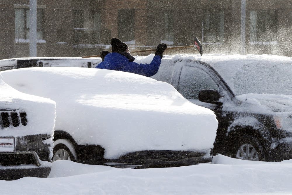
Snowfall overnight set much of the southern half of the state up for a messy commute on Wednesday morning.
Snow started to fall on Tuesday in the southern part of the state and continued well into Wednesday morning. Snowfall totals include up to 12 inches reported in Bloomington and 7 inches in Eden Prairie, said National Weather Service senior forecaster Joe Calderone.
Turn Up Your Support
MPR News helps you turn down the noise and build shared understanding. Turn up your support for this public resource and keep trusted journalism accessible to all.
Snowfall at the Minneapolis-St. Paul International Airport overturned a record previously set in 1983, with 8.8 inches reported. The weather service reported a 24-hour snowfall total of 9.2 inches in Minneapolis-St. Paul.
The storm lowered visibility and led to slippery roads in the southern half of the state.
The Minnesota State Patrol reported 449 crashes statewide between Tuesday morning and Wednesday at 10 a.m. There was also 39 reported injuries and at least 475 reported vehicles off the road.
A woman was struck and killed at 8th Street and Hennepin Avenue in Minneapolis during the Tuesday evening rush hour.

Officials also temporarily closed roads and highways in the southwestern part of the state during the storm, including Interstate 90.
Minnesota Department of Transportation spokesperson Kevin Gutknecht said the agency closed roads when snow plow drivers couldn't see where they were going.
Driving remained difficult in southeastern Minnesota on Wednesday morning. MnDOT spokesperson Mike Dougherty said high winds caused problems on roads even after the snow ended.
"People remarked when they were in Rochester or Owatonna, some area that's a little more sheltered, it seemed reasonably OK to drive," Dougherty said. "But once you left the city limits, where there wasn't a lot of cover on the land, the wind was really whipping that snow across."
By Wednesday morning, the Minnesota Department of Transportation had opened the roads it closed Tuesday, including Interstate 90 from Albert Lea to the South Dakota state line. The road closings stretched north past Mankato in south central Minnesota.

Metro Transit was reporting that 63 percent of buses were delayed about 15 minutes at the peak of morning rush hour on Wednesday.
More than a dozen cities have declared snow emergencies following the storm, including Bloomington, where there is a parking ban. Minneapolis and St. Paul declared snow emergencies on Tuesday night.
In Minneapolis, day one parking rules started Tuesday night. From 8 a.m. to 8 p.m. on Wednesday, there is no parking allowed on even side of non-snow emergency routes. From 8 a.m. to 8 p.m. on Thursday, there is no parking allowed on the odd side of non-snow emergency routes in Minneapolis.
St. Paul plowed night plow routes overnight and will start plowing day plow routes at 8 a.m. on Wednesday.
Small amounts of snow are expected in the region on Thursday and Friday, said Calderone of the National Weather Service. The state will see a slight warmup later in the weekend before a cold front moves into the state.
"We haven't had much of a winter until now," Calderone said. "As we go into the first half of next week, we are looking at a significant drop in temperatures where high temperatures will get into the single digits and mid-teens and lows will get into several degrees, both positive and negative, around zero."
