A biodiversity road trip to the headwaters - and a really big bog

It's so close, and so ours, that it's easy to forget that the area around Lake Itasca is unlike any other in North America.
The continent's four major biomes — large natural areas of plants and animals — meet here. Turn in one direction or another from up here, and in short order the land, the forests, and their inhabitants dramatically change.

One of the best ways to see those changes in stark contrast — you'd pass through three of those four biomes — is to road trip south to north through the region. When I took that trip this spring — from the Twin Cities through Itasca State Park and on to the Big Bog State Recreation Area — we encountered flora and fauna by the dozens, some we could identify along the way, and others that remained a mystery.
Luckily, we were able to consult the Bell Museum of Natural History's recently launched Minnesota Biodiversity Atlas. It was created as a way to open the Bell's collection of biological samples to the public. The interactive maps show where each specimen was collected. The atlas provides scientists and the public access to the array of specimens that chronicle the more than 560,000 organisms that make Minnesota more than just soil, rock and water.
Create a More Connected Minnesota
MPR News is your trusted resource for the news you need. With your support, MPR News brings accessible, courageous journalism and authentic conversation to everyone - free of paywalls and barriers. Your gift makes a difference.
Paired together, the road trip and the Bell's atlas offered the perfect guides to exploring this wild and, at times, prehistoric-feeling place.
Road Trip: Itasca and the Big Bog

Minneapolis: 211 miles to go
It had been at least 20 years since my last trip to Itasca, Minnesota's oldest state park. I had never been to the Big Bog, so we slapped the GoPro on the Saturn and headed north on Interstate 94. A forecast full of storms threatened a soggy reception, but today was the day.
Monticello: 173 miles to go
We took a right off the interstate and crossed Mississippi River on our way into downtown Monticello. According to the Bell Atlas, there are jack-in-the-pulpits near the bridge over the river.
Xcel Energy's nuclear power plant rose at the river's edge, humming away and keeping the lights on down the line.
We took a left turn out of Monticello, U.S. Hwy. 10 stretching out before us. Before Interstate 94 became the premier east-west route through the upper midwest, U.S. 10 held that mantle. Like many of those early routes, it follows the course of a river, connecting the communities that sprung up on the banks of the Mississippi.
Little Falls: 113 miles to go
At Little Falls, we cross the Mississippi again — and this time it's much smaller than at the crossing in Monticello. The farther north we travel the smaller and more adolescent the river becomes.
Staples: 74 miles to go
After U.S. 10's big left turn at Motley, we head into Staples, where the rail lines that run next to the highway expand into a large rail yard. Here, on one of the many stops along Amtrak's Empire Builder line, rises a station that looks nearly untouched by the passage of time.

The trees are starting to look different as we head north on Hwy. 71. Black spruce pierce the treeline like grand spearheads. Gossamer tamaracks with fresh needles sink their roots in this region where the prairie grasslands of the west, the deciduous forests of the southeast, the coniferous forests of the northeast and the tallgrass aspen parkland of the far north come together.
As if to punctuate how different the forests are in this region, white pines stretch their limbs above their neighbors like ungainly teenagers in a growth spurt.
Menahga: 35 miles to go

From the highway, we spied what appeared to be a large statue of a man with a pitchfork, holding court over a pleasant-looking park.
We stopped and had lunch in the park, which is dominated by the statue of St. Urho — the guy with the pitchfork — a fictional patron saint of Finland, who according to northern Minnesota legend, chased the grasshoppers out of Finland to save the vineyards.
We finished our lunch under the gaze of St. Urho, standing tall with a gargantuan grasshopper impaled on his pitchfork, noted the lack of grasshoppers and returned to the road.
Arrived! Itasca State Park

It isn't a trip to Itasca without visiting the headwaters of the Mississippi, where the water flows across the rocks from Lake Itasca, starting that long journey down to the Gulf of Mexico. Standing on those rocks evoked hazy memories of scampering across them as a child.
Wandering down the trails leading away from the headwaters, we heard the drumming of a ruffed grouse as the cacophony of other birds calls away. The rains of the previous night seem to have made everything even more green.

We left from the south entrance of the park, and on the way we stopped at an overlook to take a look at Itasca one last time before heading home.
On the short trail to the overlook, we found some yellow lady's slippers, the close sibling of Minnesota's state flower, blooming trailside. For many protected plants like the lady's slippers, the Bell atlas hides location data to preserve the wild plants from poachers.
And of course there was moss. In the forests of Itasca all the trees are covered with lichens or mosses or both, creating layer upon layer of verdant living organisms.
The final destination: Big Bog State Recreation Area

From Itasca we continue north, leaving the headwaters behind, with 104 miles to our final destination. We skirt Lower Red Lake to reach the largest bog in the lower 48 states, which lies on the northern side of Upper Red Lake.

The stormy forecasts failed, and the skies were filled with puffy cumulus clouds, threatening only shade.
The Big Bog State Recreation Area is divided into two parts: The smaller section, just north of the town of Waskish, includes a ranger station, with a climbable fire tower, campgrounds and cabins. Nine miles north of that first section are 500 square acres of peat bog, with a boardwalk winding through.
The boardwalk, according to the Minnesota Department of Natural Resources, was built in 2005 to provide a guided path through the varied ecosystems of the Big Bog, also known as the Red Lake Peatland. Suspended above the ground, the pierced panels allow sunlight and rain down to the plants below.
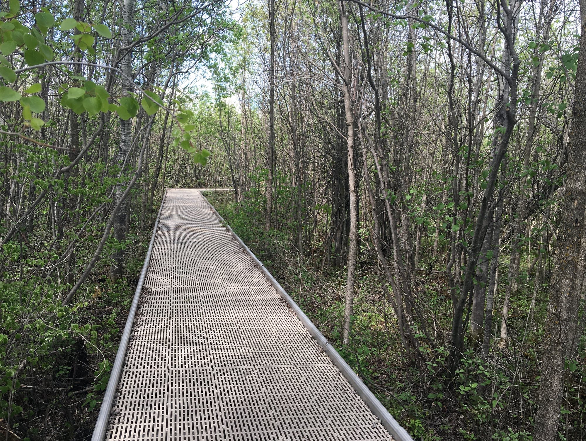
Along the winding, mile-long path, we wander through ecosystems that rapidly transition from swampy wetlands to the fens to the full bog, which stretches out as far as the eye can see.

A fen, by the way, is a type of wetland that's neither swamp nor bog. While bogs get most of their water from rainfall, the water in fens comes from streams and groundwater.
Each major ecosystem within Big Bog — the bog land, the fens and the swamps — is made up of many smaller systems, with varying plant life, humidity — and, in some places, even air temperature. Along the path there were spots that felt dramatically cooler than just before or just after, the original swamp cooler, perhaps?
In Big Bog, the fens have running water and only a small amount of moss, while the ground of the bog itself is a nearly continuous mat of sphagnum moss, according to the DNR.

The vegetation is pervasive. The moss even finds a foothold on the walkway itself, as tamarack branches catch the wind. Labrador Tea plants reach for the sunlight among the spindly trees.
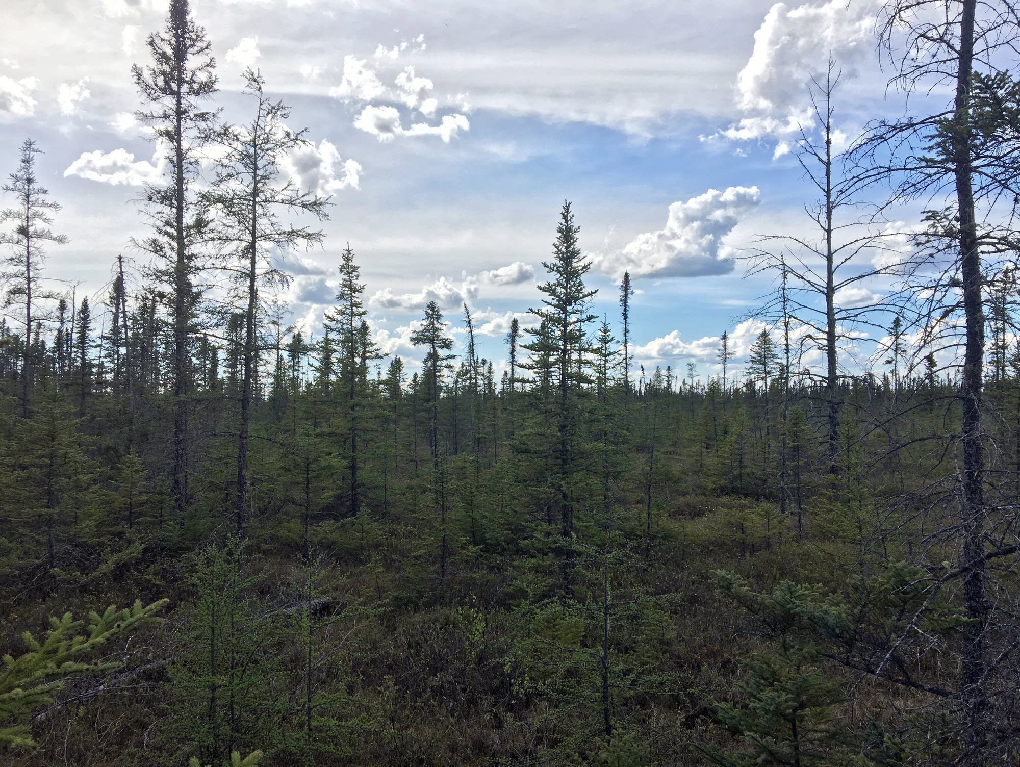
Soon, we'd moved from the black spruce and tamarack coniferous swamp forest to the more open sphagnum bogs. The plants start looking even stranger: They grow close to the bottom, with tiny leaves. The trees are extremely spindly.
There is no ground, only moss here, as we hiked into the domains of carnivorous pitcher plants. Pitcher plants cope with the nutrient poor bog by making slow snacks of insects that happen to get trapped in their water-filled maws.

As we near the end of the hike, the rings of pitcher plants poke scarlet water traps up through the moss, and cottongrass gently bobs in the breeze.
About a mile down the trail, the boardwalk ends. For the first time since we started this little adventure, there are no nearby trees — and all of the plants at the end of the walkway are close to the ground, which opens up the view of the bog, all the way down to the horizon.
The vastness of this place comes into focus here. From this spot, the bog looks endless — even though I know that Upper Red Lake is only a few miles to the south.
About the Bell Atlas

In an attempt to both preserve and make their extensive collection of scientific specimens available to scientists and the public, the Bell Museum of Natural History has created the Minnesota Biodiversity Atlas. According to Keith Barker, Curator of Birds and Curator of Genetic Resources at the Bell, the new Atlas has 560,490 records as of June 2016. And it's growing.
Roughly one in three entries has an image of a specimen. Each day, new images of specimens are being created, but it's slow going. It takes time to properly handle and set up specimens to photograph them.
In addition to being photographed, a specimen's place of origin is recorded. When looking at the atlas maps, each dot represents the location a specimen was taken from the wild and preserved.
Going your own road trip? Here are Barker's recommendations for using the atlas:

• Go to the interactive map section and find the area you are headed for.
• Draw a shape on the map, either a square or rectangle, that covers the destination.
• Click the OPEN menu on the left and hit SEARCH. Orange dots will appear on the map.
Small dots represent a location where a single specimen was found; bigger dots with numbers represent multiple specimens.
For example, the image to the right shows more than 3,500 specimens were found in this section of Itasca State Park.
The trip: Essential details
Round trip, from Minneapolis to the bog and back: 635 miles.
Don't forget the essentials before you go:

• Road atlas — On a road trip, never take directions for granted. Remember that the person who crafted that nifty GPS unit has never been where you are going — and that a paper map backup never needs cell-tower reception — or a battery charge.
• Parking — You'll need to buy a state park permit. It's $5 for a one-day pass or $25 for a sticker, valid for a year of parking at any Minnesota state park.
• Lunch — Supplies are never far away on this trip. Bemidji is about 35 miles from Itasca State Park.
• Water — Don't forget to drink enough water to keep hydrated during the drive — and the hikes.
• Speaking of charging — Don't forget to bring enough batteries and a fully charged phone.