Crookston's Red Lake River forecast, prep looks good -- so far; Red River continues its rapid rise near Fargo

Dear Minnesota: Flood season isn't over yet.
While cities and towns in the southern part of the state slowly exhale as floodwaters slowly recede, they do so with caution. Heavy rain or snow could cause the rivers to rise and crest yet again.
Forecasters say scattered showers and a few brief thunderstorms are likely this weekend, thanks to a warm front pushing in from the South.
Along Minnesota's border with North Dakota, the Red River of the North continues its slow and steady rise as ice melts and the water gets moving. In Fargo, N.D., where the river has already hit major flood stage, forecasters predict a crest at 35 feet on Sunday.
Create a More Connected Minnesota
MPR News is your trusted resource for the news you need. With your support, MPR News brings accessible, courageous journalism and authentic conversation to everyone - free of paywalls and barriers. Your gift makes a difference.
As the river flows north toward Manitoba and Lake Winnipeg in Canada, it's expected to crest in East Grand Forks, Minn., and then Oslo, Minn., in the later half of next week.
Water has already begun to cover some roads and force detours in the Red River Valley, and are expected to continue through the weekend. And while floodwaters will continue to drench farm fields ahead of planting season, officials in Fargo, Moorhead and Grand Forks aren't expecting the kind of widespread neighborhood flooding that has devastated their cities in the past, thanks in large part to diversion and mitigation.
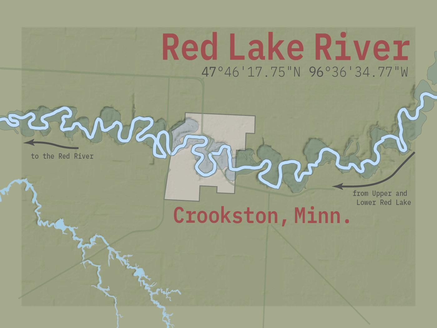
Crookston: Red Lake River outlook and preparations looking good — so far
As what is being described as an "ideal" start to the spring melt continues, the Red Lake River in Crookston, Minn., has begun its annual rise, and preparations continue to take place in advance of an upcoming week that hydrologists at the National Weather Service say will be especially key, as river levels in Crookston throughout the Red River basin rise significantly.
A daily pattern that has featured daytime high temperatures sufficient to spur consistent melting has mostly been followed by nighttime low temperatures cold enough to allow for a refreeze. But this weekend, daytime highs are expected to reach the 50s, and nighttime lows might not drop below freezing. When the snow continues to melt overnight, that's when runoff increases and river levels tend to rise rapidly. In addition, there's a chance of rain this weekend.
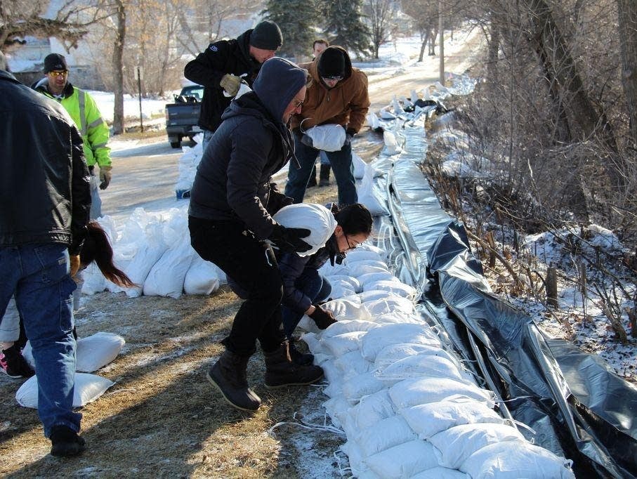
Crookston's certified levee system protects the community from a Red Lake River crest of 31 feet, but there are still some vulnerable spots, such as the area of Riverside Avenue.
Wednesday, a contingent of University of Minnesota Crookston students, supervised by public works director Pat Kelly, built a sandbag wall along the lowest portions of the old dike and wooden flood wall that run along the street. Kelly said the plan was to place 5,000 to 7,000 sandbags in that area. The bags were filled by a Sentence to Service crew made up of people incarcerated at the Northwest Regional Corrections Center in Crookston.
At press time Thursday, the Red Lake River in Crookston was approaching a depth of 9 feet with very little ice breakup apparent. The river channel snakes its way through town with lots of oxbows and sharp bends, and ice jams are always a concern.
According to the latest National Weather Service flood outlook, from April 8 to 22, there's a 10 to 25 percent chance the river in Crookston will top 27.5 feet. From April 8 through 15, there's a 25 to 50 percent chance the river will exceed a level of 25 feet.
The Polk County Board of Commissioners this week officially declared a flood emergency. By approving the resolution now, as the flood threat ramps up county officials will be able to access services and resources they may need. At the county level, while officials keep a close eye on various river levels, the threat of overland flooding — especially this spring — is likely a bigger concern. The Crookston City Council might consider approving a similar flood emergency declaration when they meet April 8.
Meanwhile, Kelly and Fire Chief and Emergency Manager Tim Froeber continue to meet their staffs to make sure everyone is on the same page, and Blake Carlson from Widseth Smith Nolting, who's an expert on drainage, soil moisture and runoff, continues to provide his input.
Froeber has met with his Community Emergency Response Team members and his ward captains, and Parks and Recreation staff are preparing Central Park for the likelihood that it will be inundated by river water. They've removed electrical panels in the campground area and disc-golf cages in the park's lower areas. Crookston Police Chief Paul Biermaier reports that the police department is preparing for high water as well by inventorying and testing equipment and updating operating procedures during the high-water event.
— Mike Christopherson, Crookston Daily Times | Crookston, Minn.
Red River Valley: Road closures and ice jams

The Red River of the North in the Fargo-Moorhead area will likely reach its highest level this weekend, and while the floodwaters aren't expected to cause significant problems for residents of either border city, many rural residents are beginning to be isolated by flooded roads.
As the Red River rises, it forces tributaries to back up, causing water to pool in rural areas. In some locations around the region in northeastern North Dakota and northwestern Minnesota, ice jams have become a problem as ice melts and rivers begin to flow.
Homeowners in affected areas have been warned to prepare for several days of isolation.
Benson said he expects water to flow over rural roads in at least 100 locations.
"And then once those get overtopped, that extra water kinda spills in and fills in other sections of land and surrounds people's homes," he said, adding that residents at about 50 to 100 rural homes will need to build their own sandbag dikes to protect against the rising waters.
"I expect that people who during past floods have lost access or had their homes threatened by flood waters should be prepared for that this year," Benson said.
Floodwaters are expected to recede in Fargo and Moorhead by the middle of next week and in rural areas by late next week.
— Dan Gunderson | Moorhead, Minn.
Updraft weather blog: Rain in the forecast?
Rainfall totals this weekend will add up. Widespread half-inch totals look likely.
Locations that pick up local downpours in thundershowers could top out around an inch this weekend. We're into the convective rain season now. Precipitation totals can be highly variable over short distances this weekend.
Cloud cover is critical this time of year for temperatures. Areas that stay cloudy will hover in the 40s and 50s this weekend. But if the air mass is warm enough and the sun pops out for a couple of hours, temps will spike into the 60s.
Monday looks like the sunniest, warmest day. Many models suggest a shot at the season's first 70-degree temperature in the Twin Cities Monday.
— Ron Trenda | Updraft weather blog