Midweek rains bring second crest on southern Minn. rivers

The days are longer and the forecast is sunny, but the uncertainty of flooding season continues across southern Minnesota.
The effects of the midweek rains are coming to fruition, as the Minnesota and Mississippi rivers are projected to hit their second flooding-season crests over the weekend.
Meanwhile, in northwestern Minnesota, the town of Oslo has become an island, thanks to floodwaters that keep it cut off from the surrounding area for sometimes weeks at a time. And the Red River continues its slow northern crawl as it crests toward Pembina, N.D., and onward to Winnipeg.
Create a More Connected Minnesota
MPR News is your trusted resource for the news you need. With your support, MPR News brings accessible, courageous journalism and authentic conversation to everyone - free of paywalls and barriers. Your gift makes a difference.
Minnesota River: Roads open after mudslide; more to close thanks to floods
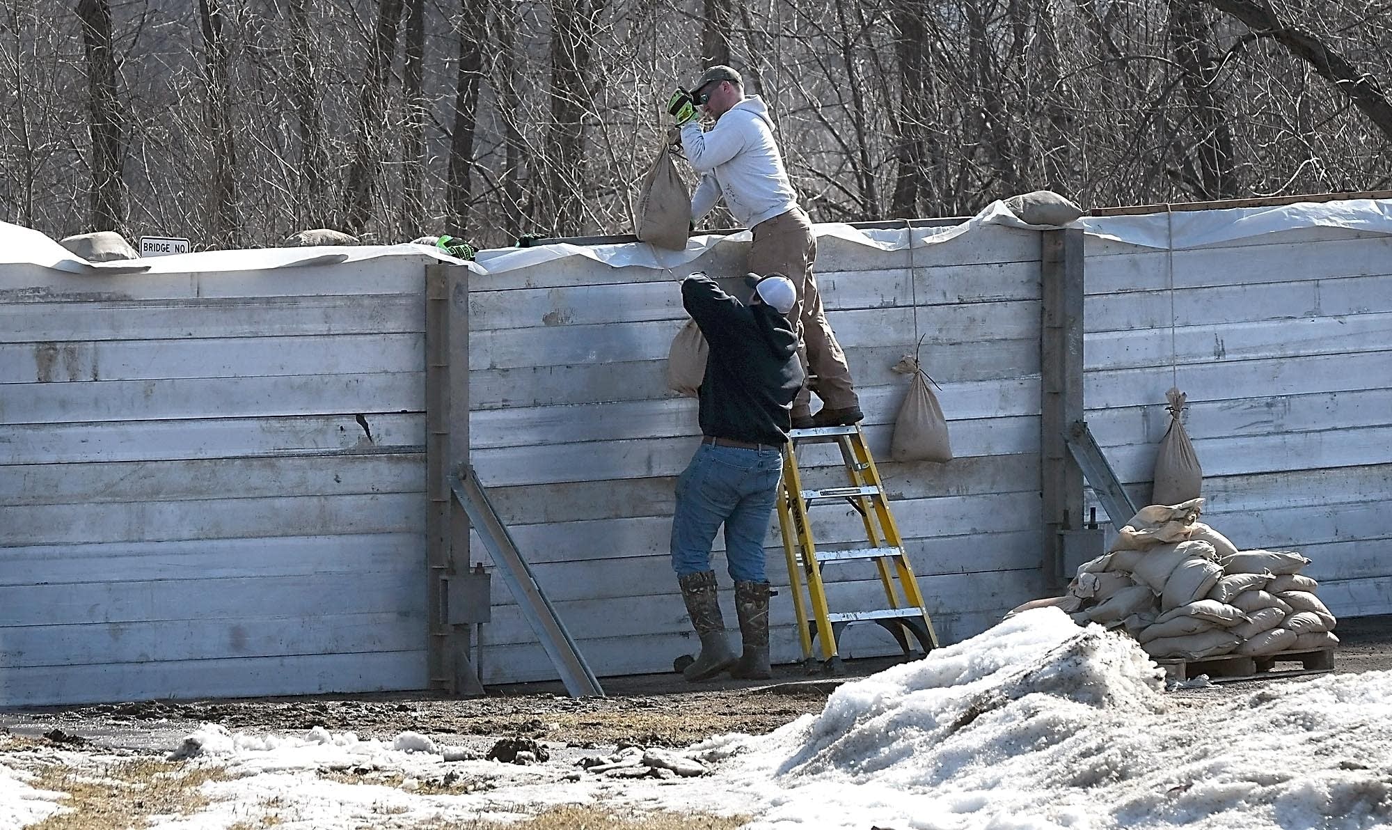
The overlap this year of the rainy season and the flooding season has caused several logistical headaches for drivers in south-central Minnesota.
The southbound lanes of U.S. Highway 169 between St. Peter and Mankato were closed this week after mudslides triggered by heavy rains Wednesday made the road impassable. But after crews cleared the mud, trees and other debris from the roadway, the Minnesota Department of Transportation announced Thursday evening that the lanes had reopened.
The four-lane highway runs along a steep bluff in the area, making it vulnerable to runoff along the west side of the road.
And now after the rains come the rising waters of the already swollen Minnesota River.
MnDOT warned that a second wave of flooding along the river may force another closure of Highway 93 at Le Sueur and Highway 99 east of St. Peter in the coming days. Both roads were closed when the river rose for the first time this spring just after the winter snowmelt.
Meanwhile, two roads outside Henderson — Highway 19 to the east and Highway 93 to the south — have been closed for about a month, and will remain closed as the Minnesota River heads toward its second springtime crest this weekend.
By Thursday night, KEYC-TV reported, the city had already begun the work of reinstalling the floodgates it had cleared after the last crest.
Red River flooding: Semi stuck in floodwaters; driver cited
The driver of a semi has been cited after he ended up stuck in floodwaters in Richland County in North Dakota, just northwest of Wahpeton, N.D.
Sheriff Larry Leshovsky says the driver went around a barricade along Highway 8 near Galchutt, N.D. The sheriff says the level of the Wild Rice River will have to drop before the semi and trailer can be towed. The semi driver and a passenger were rescued by boat.
KFGO Radio says the North Dakota State Patrol is handling the investigation.
— The Associated Press | Galchutt, N.D.
Great Lakes: Thawing ice allows re-deploying of data buoys
As ice thaws around the Great Lakes, technicians are preparing to re-deploy buoys that gather a wealth of information for use in research, water safety efforts and recreation.
About a dozen research institutions operate buoys in the lakes. Many of them provide data to the nonprofit Great Lakes Observing System, which makes it available online.
Its website offers real-time data from the buoys, which are returned to the water as soon as harbors and boat launches are ice-free.
It can help boaters and anglers avoid potentially dangerous conditions, while scientists get material that feeds computer models predicting weather and other lake characteristics.
Ed Verhamme of the Ann Arbor-based engineering firm LimnoTech says spring can be a particularly hazardous season, as conditions are often rough and change quickly.
— The Associated Press | Ann Arbor, Mich.
Flooding technology: Drones, supercomputers and sonar deployed against floods
An arsenal of new technology is being put to the test fighting floods this year as rivers inundate towns and farm fields across the central United States. Drones, supercomputers and sonar that scans deep under water are helping to maintain flood control projects and predict just where rivers will roar out of their banks.
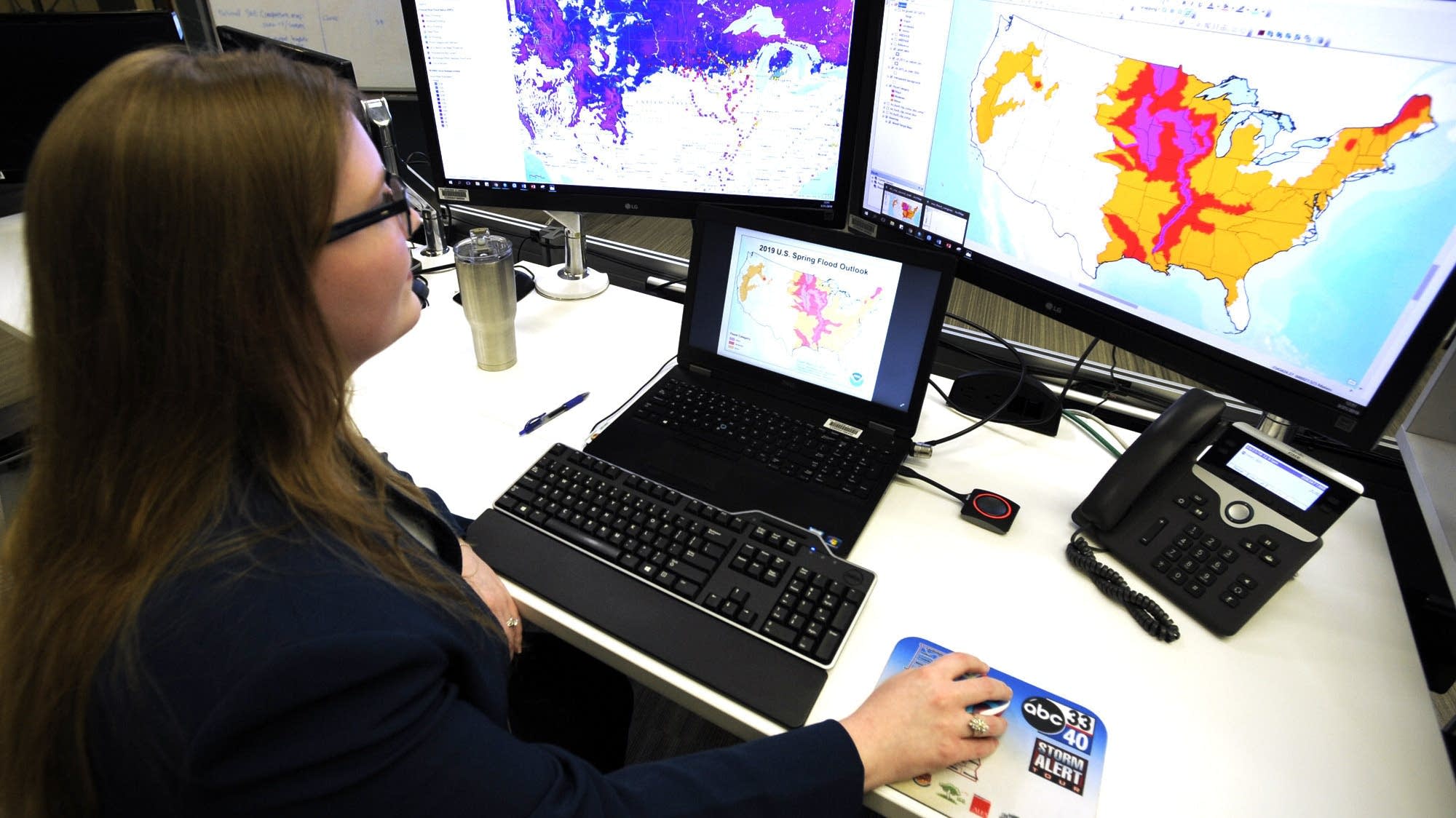
Together, these tools are putting detailed information to use in real time, enabling emergency managers and people at risk to make decisions that can save lives and property, said Kristie Franz, associate professor of geological and atmospheric sciences at Iowa State University.
The cost of this technology is coming down even as disaster recovery becomes more expensive, so "anything we can do to reduce the costs of these floods and natural hazards is worth it," she said. "Of course, loss of life, which you can't put a dollar amount on, is certainly worth that as well."
U.S. scientists said in their spring weather outlook that 13 million people are at risk of major inundation, with more than 200 river gauges this week showing some level of flooding in the Mississippi River basin, which drains the vast middle of the United States. Major flooding continues in places from the Red River in North Dakota to near the mouth of the Mississippi in Louisiana, a map from the National Weather Service shows.
"There are over 200 million people that are under some elevated threat risk," said Ed Clark, director of the National Water Center in Tuscaloosa, Ala., a flood forecasting hub.
Much of the technology, such as the National Water Model, didn't exist until recently. Fueled by supercomputers in Virginia and Florida, it came online about three years ago and expanded streamflow data by 700-fold, assembling data from 5 million river miles of rivers and streams nationwide, including many smaller ones in remote areas.
"Our models simulate exactly what happens when the rain falls on the Earth and whether it runs off or infiltrates," Clark said. "And so the current conditions, whether that be snow pack or the soil moisture in the snow pack, well that's something we can measure and monitor and know."
Emergency managers and dam safety officials can see simulations of the consequences of flood waters washing away a levee or crashing through a dam using technology developed at the University of Mississippi — a web-based system known as DSS-WISE. The software went online in 2017 and quickly provided simulations that informed the response to heavy rains that damaged spillways at the nation's tallest dam in northern California. The program also helped forecast the flooding after Hurricane Harvey in Texas and Louisiana that year.
Engineers monitoring levees along the Mississippi River have been collecting and checking data using a geographic information system produced by Esri, said Nick Bidlack, levee safety program manager for the Memphis district of the U.S. Army Corps of Engineers. The company produces mapping tools such as an interactive site showing the nation's largest rivers and their average monthly flow.
On the Mississippi River, flood inspectors use smartphones or tablets in the field to input data into map-driven forms for water levels and the locations of inoperable flood gates, seepages, sand boils or levee slides, which are cracks or ditches in the slopes of an earthen levee. Photos, videos and other data are sent to an emergency flood operation center in real time, allowing Corps officials to visualize any problems and their exact location, instantly informing the response, Bidlack said.
"If people in the field have concerns about something, they can let us know to go out there and look at it," Bidlack said. "There's a picture associated with it, a description of it, and it helps us take care of it."
Corps engineers are increasingly flying drones to get their own aerial photography and video of flooded areas they can't otherwise get to because of high water or rough terrain, said Edward Dean, a Corps engineer.
"We can reach areas that are unreachable," Dean said.
The Corps also now uses high-definition sonar in its daily operations to survey the riverbed, pinpointing where maintenance work needs to be done, said Corps engineer Andy Simmerman.
The Memphis district uses a 26-foot survey boat called the Tiger Shark, with a sonar head that looks like an old-fashioned vacuum cleaner and collects millions of points per square inch of data, Simmerman said.
The technology has helped them find cars and trucks that have been dumped into the river, along with weak spots in the levees.
"These areas are 20 to 80 feet underwater, we'd never get to see them without sonar," Simmerman said. "The water never gets low enough for us to see a lot of these failures."
During recent flooding near Cairo, Ill., a culvert that should have been closed was sending water onto the dry side of a levee. The sonar pointed engineers to the precise location of a log that was stuck 20 feet deep in murky water, keeping the culvert open. Plastic sheathing and sandbags were brought in to stop the flow and save the land below.
"The sonar definitely made a difference," said Simmerman. "A big success."
— Adrian Sainz and Jeff Martin, The Associated Press | Memphis, Tenn.