In Red River flood diversion fight, no one has the high ground

Most of the time, the Buffalo-Red River Watershed District board deals with neighborhood disputes over things like ditches. But this year, the board has found itself in a position to alter the fate of the massive, $2.75 billion diversion effort to protect Fargo and Moorhead from floodwaters.
Watershed board members sat patiently through three hours of presentations and public comments Tuesday night at the community center in Dilworth, Minn. They've heard it all before: Since January, when the board voted to contest a permit the Minnesota Department of Natural Resources granted the diversion project, they've been bombarded with meetings, phone calls and emails from all sides.
Next month, the watershed board will have to decide whether to continue their challenge of the project, and whether to grant their own permit for construction to be done in their territory.
It's just one more small step in a long, complex project that still faces legal hurdles and funding challenges. If the board continues to contest the DNR permit, an administrative law judge will determine if the permit follows state law. That process could take at least a year, and could potentially delay work on the diversion. There is also a pending federal lawsuit, which means a judge continues to have oversight of all construction.
Create a More Connected Minnesota
MPR News is your trusted resource for the news you need. With your support, MPR News brings accessible, courageous journalism and authentic conversation to everyone - free of paywalls and barriers. Your gift makes a difference.
At the heart of the watershed board's concern: The project to divert flood water around Fargo and Moorhead through a 30-mile channel would push floodwaters upstream, inundating some rural residents who have never been flooded before.
Farmer Mark Askegaard spoke for a coalition of people opposed to the project Tuesday night. He urged the board to continue with its challenge, saying the diversion would protect land in North Dakota for future development while flooding his farm — and the cemeteries where generations of his family members are buried.
"It's unethical for this water district to push water on property and cemeteries that do not flood so that other people can enrich themselves," Askegaard said, to applause from the crowd. "This is wrong."
Askegaard asked the board to consider other options for flood control along the Red River.
The watershed board listened, but said little. After the meeting, board president Jay Leitch said many diversion opponents see the watershed board as a last hope for stopping the project which has been in the works for more than a decade, or forcing a significant redesign. But, he said, it's not that straightforward.
"Buffalo-Red cannot stop this project," he said. "A lot of people want us to, and think we can. We've been told by others, such as the [Army] Corps of Engineers, that if we deny the permit, they may go ahead with it anyway."
So, instead, Leitch said, he is focusing on negotiating as many concessions as possible from the Fargo-Moorhead Diversion Authority, the organization building the project, that will ensure that upstream residents whose land will be flooded by the project are treated fairly.
"That's called justice," he said. "Treating each side fairly. And that's what we want to do. Get them to treat each side fairly. And the Diversion Authority has expressed an interest in working with us to see if we can achieve that justice and fair treatment of everybody."
Fair treatment, he said, might include protecting farmsteads with levees rather than demolishing them, and ensuring adequate flood protection for small towns in the affected area.
Moorhead Mayor Johnathan Judd, who sits on the board of the Fargo Moorhead Diversion Authority, assured the board and the audience Tuesday night that any conditions put on the project to protect upstream residents will be followed.
"I want you to honestly understand, I'm not just paying lip service," said Judd. "I honestly understand and respect the position you are in. And I also understand, to protect the city of Moorhead, there's going to be impacts elsewhere."
The challenge of any flood diversion project is that the water needs to go somewhere. And in the Fargo-Moorhead flood diversion project's earlier design, much of that flood water would shift from North Dakota and into Minnesota. So Minnesota initially rejected a permit for the project.
Then a task force came up with a Plan B to reduce the impact on Minnesota, and the state DNR issued a permit for the new plan. That's the permit the watershed board is now contesting. The board will take written comments until May 10. Three days later, the board will make its decision, adding another milestone to a project more than a decade in the works.
A history of flooding — and flood control
Flood control has long been a concern in the Red River Valley. The river flows north through what was once the bottom of glacial Lake Agassiz. The river meanders along a flat, winding path, falling an average of about one foot per mile as it flows northward from Wahpeton, N.D., to Winnipeg, Manitoba. That subtle descent means the river flows slowly, and has not cut a deep channel in the earth that surrounds it. When the water rises, it quickly spills out of the channel and spreads across the flat terrain.
So cities and counties, plus state and federal governments, have all made efforts to tame the the Red River of the North. They started in earnest with dams in the first half of the 20th century. The U.S. Army Corps of Engineers built the White Rock Dam about 30 miles south of Breckenridge, Minn., on the Bois de Sioux River in 1941. The dam created Mud Lake and Lake Traverse, where water from the annual snowmelt is collected each spring to manage the flow. Orwell Dam was built in 1953 on the Otter Tail River near Fergus Falls, Minn., to create another place to hold water during floods.
The Otter Tail and Bois de Sioux meet on the border of Breckenridge, Minn., and Wahpeton, N.D., and form the Red River, which flows north to Lake Winnipeg, which eventually flows into Hudson Bay.
For decades, communities along the Red River have built levees — earthen berms near river banks, or around small towns and farms that are designed to hold back the water — to control flooding. But some of the area's largest, costliest flood-control projects have been built since record floods in 1997 caused heavy damage in Breckenridge, Minn., Grand Forks, N.D., and East Grand Forks, Minn.
Grand Forks and East Grand Forks are now protected by a $403 million system of levees and flood walls, protecting the cities against river levels much higher than the record river level that flowed over levees in 1997. Floods in Breckenridge are managed by a $45 million diversion channel. The Army Corps of Engineers estimates the Breckenridge project has prevented $164 million in damage from subsequent floods since it became operational in 2005.
Dueling diversion plans in Fargo-Moorhead project
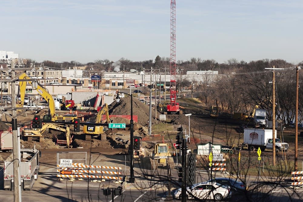
Fargo and Moorhead were next. The Fargo Moorhead Area Diversion Project started with a study agreement between the U.S. Army Corps of Engineers and local governments in 2008.
Fargo and Moorhead long depended on sandbags and temporary earthen levees to fight floods. But as the cities grew and flood levels increased, the effort to protect residents took millions of sandbags, miles of temporary levees — and untold hours of effort.
A record flood on the Red River in 2009 forced residents to fill some seven million sandbags in 10 days. The near catastrophe galvanized community support for a significant flood protection project.
The Army Corps of Engineers developed several possible approaches for diverting Red River floodwaters away from the population centers of Fargo and Moorhead. The options included a diversion channel on the Minnesota side of the Red River or a diversion channel on the North Dakota side of the river. The federal government's preferred project was the Minnesota diversion because it was most cost-effective to construct. But local officials preferred the North Dakota diversion — so that became the designated project.
The U.S. Army Corps of Engineers conducted an environmental review of the proposed project and found "no significant impact" on the surrounding ecosystem. But the diversion also requires state and local permits which would prove to be significant hurdles for the project.
The original cost was estimated at $1.4 billion. It has since climbed to $2.75 billion.
The North Dakota plan was more expensive because the diversion channel crossed five smaller rivers that flow into the Red River. That trajectory required creative engineering to allow those streams to flow over the diversion channel under normal conditions, but to spill into the diversion channel during floods.
It was designed with a 36-mile channel that would divert part of the Red River around Fargo during a flood. But that idea ran into trouble when an analysis determined that using the channel in that way would increase the river's flood levels downstream — as far as the Canadian border.
That finding led to a redesign of the project that included a large, roughly 12-mile levee, south of Fargo and Moorhead, that would hold back floodwaters while slowing the flow through a 30-mile diversion channel. Under Minnesota law, the levee was large enough to be considered a "high hazard dam," which means a state dam permit is required to build it.
That redesign addressed the flooding concerns of residents downstream, but angered residents upstream, whose land would be inundated during floods because of the dam. In April 2017, local officials ceremonially broke ground on the project, but it was already mired in legal and regulatory challenges.
While work on the Red River diversion through North Dakota moved ahead, local officials aggressively pursued more traditional flood mitigation projects. They bought hundreds of homes in flood-prone areas along the Red River Valley and replaced them with permanent levees and flood walls. The work provided immediate flood protection, but also was designed to work in concert with the proposed diversion to protect against even higher future floods.
In 2013, a coalition formed by neighboring Wilkin County, Minn., and Richland County, N.D., filed a federal lawsuit arguing the project could not be built without a Minnesota permit.
In 2014, despite the litigation in progress, the U.S. Congress authorized construction of the project, a key step needed to get federal funding for what was then estimated to cost $1.8 billion.
Local governments join forces to push the project forward
In an effort to expedite funding and construction, local officials chose to pursue a public-private partnership, called a P3, which would hire a single contractor to build the channel using private investors to pay for part of the cost upfront. The approach extended the payback time for the local share of the project. Using a private contractor would theoretically shorten the construction time and save on overall construction costs. The contractor would also manage the project after it is operational. The private contractor bids for the P3 contract will be critical to the ultimate cost of the project.
The P3 approach has been used across the country for transportation projects like toll highways, high-occupancy toll lanes or rail transit projects, but the idea of using it for a flood-control project was new.
The Army Corps of Engineers liked the idea and made the Fargo-Moorhead flood diversion a demonstration project, ensuring it would be a high priority for the agency.
In 2016, voters in Fargo and Cass County, N.D., approved sales tax increases to help pay for it.
But later that year, the Minnesota DNR denied the permits required in order to work in public waters and build a high hazard dam, key permits the project needed to move forward. The DNR cited the diversion's environmental and sociological impacts as reasons for the denial.
One of the DNR's major findings was that the project would shift too much floodwater from North Dakota into Minnesota, protecting land in a flood plain near Fargo, while flooding areas of Minnesota that had never before flooded.
Shortly after rejecting the permit application, the DNR joined the federal lawsuit filed by upstream opponents arguing the project could not proceed without Minnesota permit authority.
A few months later, a federal judge agreed and halted construction.
A Plan B emerges — but not everyone's satisfied
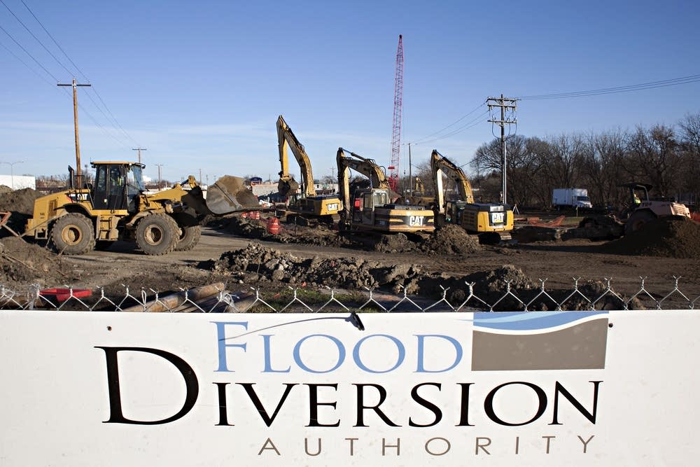
Local officials implored state leaders to help save the flood control project and move beyond the impasse. Minnesota Gov. Mark Dayton, a Democrat, and North Dakota Gov. Doug Burgum, a Republican, convened a task force in October 2017 to redesign the project in a way that would address Minnesota regulators' concerns.
After weeks of work, a Plan B was submitted to the DNR for permit approval. By that point, the cost of the project had ballooned to an estimated $2.75 billion.
More than a year after the task force came together, in late December 2018, the DNR issued a permit for the revamped project, with more than 50 conditions included that the project would need to meet in order for the work to move forward.
But the small Minnesota towns of Wolverton and Comstock, located upstream of Fargo-Moorhead, and a local watershed board — the Buffalo-Red River Watershed District — said they want to challenge the DNR permit conclusions. Under Minnesota law, local governments can contest the facts of DNR permits, leading to a process where an administrative law judge holds a hearing and determines if the permit follows state regulations.

That request voids the permit until the appeal process is completed, or until the appeal is dismissed or dropped.
In January 2019, a judge in the federal case — the one brought by the upstream coalition six years ago — said there could be no work on Plan B until Minnesota permit appeals — including the appeal of the DNR permit — were complete.
Earlier this month, the Fargo Moorhead Diversion Authority asked the judge in the federal case to modify the permit to allow construction to resume, as long as the specific work being done met Minnesota permit requirements. The court reserved the right to stop work again if conditions change or permit conditions are not met
Fargo-Moorhead officials still hope to begin construction on the diversion project this spring and complete the massive project by the end of 2025.
Funding the construction remains a challenge. The federal government has committed to contributing $750 million, but the money has not been appropriated by Congress. The North Dakota Legislature has balked at increasing the level of state spending, and negotiations continue at the Capitol in Bismarck. Revenues have been lower than predicted from local sales taxes earmarked for the project.
What it's cost: Fargo-Moorhead Diversion project
• $750 million from the federal government
• $870 million from the state of North Dakota
• $1.04 billion from the local sponsors funded through existing sales taxes
• $43 million to be requested from the state of Minnesota for continued mitigation work in Moorhead
• Another $43 million to be requested from the state of Minnesota for the diversion project
Approximately $430 million has already been spent on the project, leaving a cost of about $2.3 billion to complete it.