
Sunday blizzard warning NW Minn., fog and rain shower chance in Twin Cities; Monday snow
Heaviest snow area shifts as we go from Sunday into Monday
Go Deeper.
Create an account or log in to save stories.
Like this?
Thanks for liking this story! We have added it to a list of your favorite stories.


A low pressure system is still delivering snow this Sunday to much of the northern third of Minnesota, plus west-central Minnesota. That low pressure system will weaken Sunday night into Monday as a low pressure system over the western Great Lakes strengthens and spins snow back over us.
The National Oceanic and Atmospheric Administration's North American Mesoscale (NAM) forecast model shows the potential precipitation pattern from Sunday afternoon through Monday evening:

Green indicates rain, while blue is snow and pink/purple is a wintry mix in the loop.
Dense fog advisory in the Twin Cities
Turn Up Your Support
MPR News helps you turn down the noise and build shared understanding. Turn up your support for this public resource and keep trusted journalism accessible to all.
A dense fog advisory continues until 1 p.m. this Sunday afternoon in the Twin Cities metro area and areas to the west and into south-central Minnesota:
Check updates to see if the advisory has to be extended.
Blizzard warning and winter storm warnings
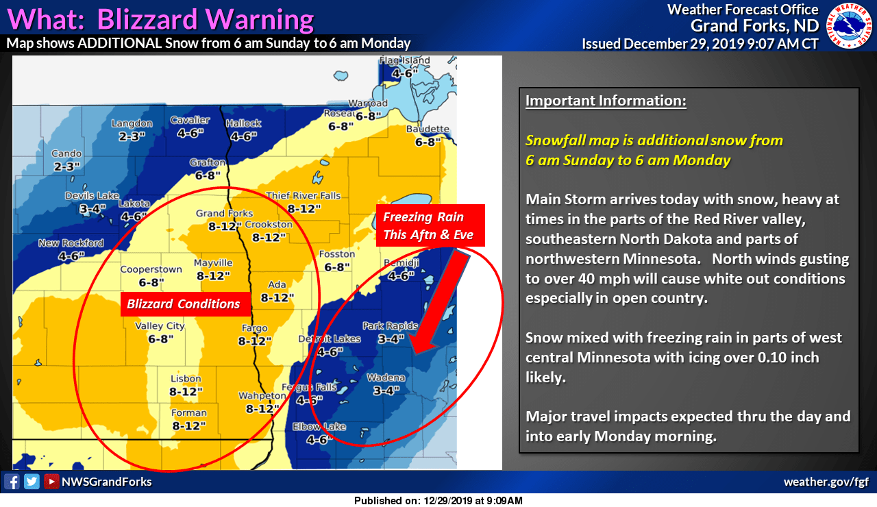
A blizzard warning continues through Sunday and the overnight hours of Sunday night for several counties along the Red River:

Here are blizzard warning details from the Grand Forks office of the National Weather Service:
944 AM CST Sun Dec 29 2019 ...BLIZZARD WARNING REMAINS IN EFFECT UNTIL 6 AM CST MONDAY... * WHAT...Blizzard conditions. Additional snow accumulations of 5 to 8 inches and a glaze of ice. Winds gusting as high as 45 mph. Visibilities of less than a quarter mile, especially in open country. * WHERE...Portions of east central and southeast North Dakota and from Crookston to Breckenridge Minnesota. * WHEN...Until 6 AM CST Monday. * IMPACTS...Widespread falling and blowing snow will significantly reduce the visibility today and tonight, making travel very difficult to impossible. Whiteout conditions are expected in open country. Power outages are also possible due to the ice and wind today and tonight. PRECAUTIONARY/PREPAREDNESS ACTIONS... Travel should be restricted to emergencies only. If you must travel, have a winter survival kit with you. If you get stranded, stay with your vehicle.
Winter storm warnings continue elsewhere in northwestern and north-central Minnesota.
Winter storm warnings also continue in parts of northeastern Minnesota Sunday afternoon:
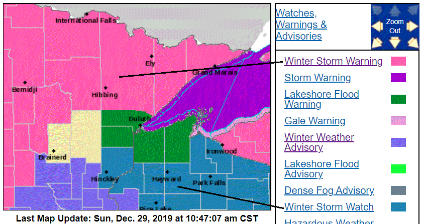
The winter storm watch from Hinckley into northwestern Wisconsin is for Monday and Monday evening. The winter weather advisory in central Minnesota begins Sunday evening. Check updates.
Here are details of the Lakeshore flood warning in the Duluth area through Sunday afternoon:
National Weather Service Duluth MN 721 AM CST Sun Dec 29 2019 ...LAKESHORE FLOODING TODAY... .A strong storm will produce a prolonged period of strong east to northeast winds through this afternoon which will pile up water along the western portion of Lake Superior. This will lead to lakeshore flooding - especially in the Canal Park, Park Point, and Wisconsin Point areas. Beach and shoreline erosion is also a concern as wave heights will build to 12 to 16 feet. Winds and waves will gradually subside late this afternoon, which will end the threat of lakeshore flooding.
Additional snow amounts
Here are Sunday through Sunday night snow forecasts for northwestern Minnesota:
Parts of northeastern Minnesota will see several inches of additional snow, with highest amounts near the tip of the arrowhead:

Duluth will see a wintry mix and very strong winds, gusting over 50 mph at times this Sunday.
We could see a wintry mix and some snow in the Twin Cities metro area after midnight Sunday night, with accumulating snow Monday and Monday night. Our snow amounts in Minnesota and Wisconsin could look like this Monday and Monday night:
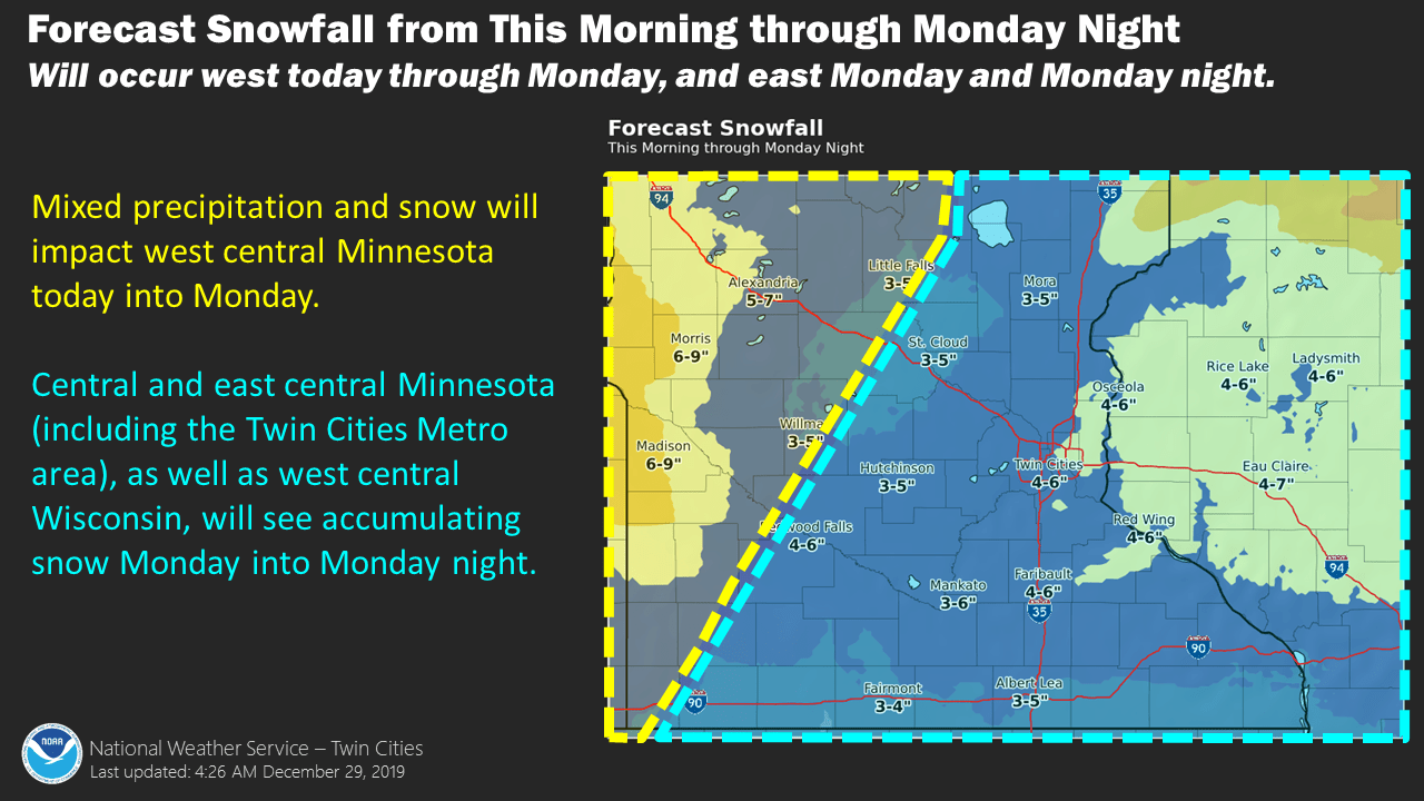
A winter weather advisory starts in the metro area at midnight Sunday night and runs until 6 a.m. Tuesday.
I’d say that the Twin Cities metro area has the potential for 3 to 5 inches of snow Monday into Monday night.
Northeastern Minnesota and northwestern Wisconsin snow amounts Monday and Monday night could look like this:

Updates on the winter storm will be posted by the NWS offices in the Twin Cities, Duluth, Grand Forks, La Crosse and Sioux Falls.
The Minnesota Department of Transportation will have updated road conditions. Wisconsin road conditions can be found here.
You can hear updated weather information on the MPR network, and you’ll see updated weather info on the MPR News live weather blog.
Snowfall reports can be found here. Just hover over any location on the map at that link to get the location and time of the snow measurement. Move the slider in the upper left corner of the linked map to “48 hours” to include reports from earlier in the weekend.
Temperature trends
Sunday highs are expected to range from the 20s in northwestern Minnesota to the 40s in the southeast plus portions of west-central Wisconsin.
Monday highs reach the 30s in the east:
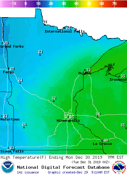
Highs will probably occur early Monday, and temps are expected to slowly fall Monday afternoon.
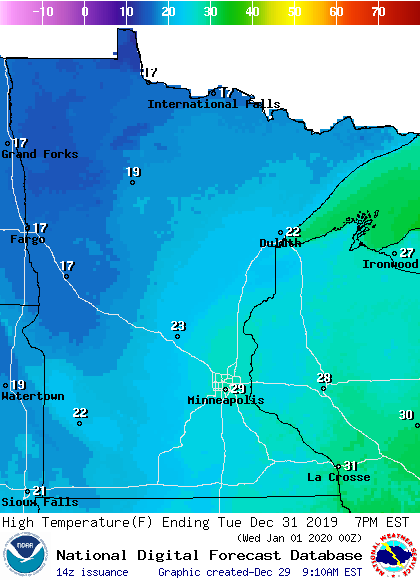
Tuesday highs will be mainly in the 20s, with teens northwest:
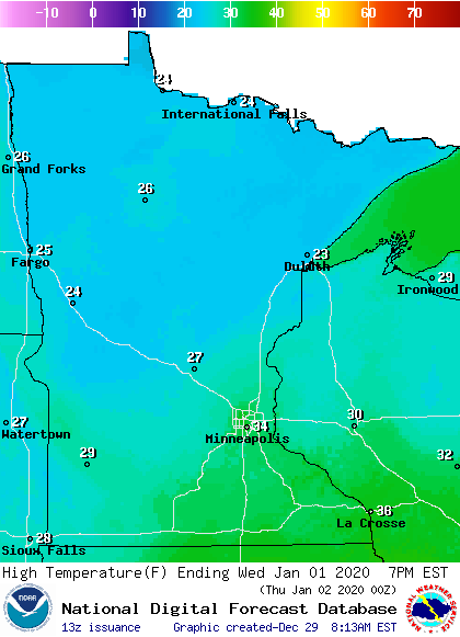
We start the New Year with highs in the 20s and 30s:
Warmer than normal
Despite a nine-day stretch of chilly weather in the middle of December 2019, the average temperature (average of all the high temps and low temps) is running 2.5 degrees warmer than normal at MSP airport this month.
Here are the stats, with the “dep” column showing the departure from normal for each day:

Today (Sunday) will be our 11th consecutive warmer than normal day in the Twin Cities.
Programming note
You can hear my live weather updates on MPR News at 7:35 a.m., 9:35 a.m. and 4:35 p.m. each Saturday and Sunday.

