Arctic air moves into Minnesota, (slight) warm-up in sight
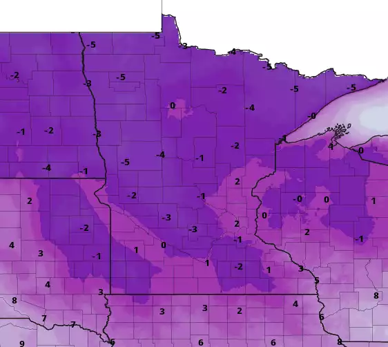
Forecast high temperatures Monday
NOAA via pivotal weather
Go Deeper.
Create an account or log in to save stories.
Like this?
Thanks for liking this story! We have added it to a list of your favorite stories.
Audio transcript
[MUSIC PLAYING] CATHY: The arctic weather is one of our other top stories. Windchill warnings and advisories covered the state this morning and temperatures in most places won't get above 0 for the rest of the day. NPR news meteorologist Sven Sundgaard is here to help us understand the intense cold snap. Hey, Sven. How are you doing?
SVEN SUNDGAARD: I'm warm and toasty. I haven't been outside yet today.
CATHY: Good for you.
SVEN SUNDGAARD: How about you?
CATHY: That's actually a good move, I think. OK, so are we done with the windchill advisories and the warnings?
SVEN SUNDGAARD: We are for the moment. Northwestern Minnesota still is under windchill advisory through noon tomorrow, but don't be shocked if later today there are some more issued for tonight. The winds will be lighter, but some of us in southern Minnesota will see our coldest temperatures yet tonight. We might even get down to 10 below in the twin cities. We've only been as cold as 8 below in this latest cold snap, but Kabetogama is the winner from this morning. 38 below is the low there. 37 below in Celina, and Barris 36 below, and it was 35 below in Eveleth.
CATHY: That's impressive. And we're talking about the air temperature, not the windchill.
SVEN SUNDGAARD: That is just the air temperature. Yeah, the windchills this morning were in the 40s below 0. It is still about a 40 below 0 windchill up around Hallock and Fosston, where the air temperature is about 15 below 0, but the wind has increased a bit. 13 mile an hour breeze really dropping the windchills.
KATHY: I know there's some bellyaching out there, Sven. It's just too darn cold. However, those of us who are natives do remember that it could be worse. It could be worse.
SVEN SUNDGAARD: Oh, for sure.
CATHY: And it has been worse.
SVEN SUNDGAARD: Yeah, and this is what I've been reminding people, and I get either kind of a grimace face or an eye roll, but historically, the temperatures were much colder in our coldest periods of the winter. It averaged about 40 below to 26 below 0 for your average coldest temperature of the winter 50 years ago.
Most stations now are about nine degrees warmer than that, and the state climate office reminds us too that the frequency of those extremes, which is defined by 35 below 0 in northern Minnesota or 25 below 0 in southern Minnesota, has decreased by as much as 90%. So it doesn't get nearly as cold as it used to nor as frequently. So I don't know if that helps, but soak it up and enjoy it.
CATHY: A few more cold days to kind of muddle through here.
SVEN SUNDGAARD: Yeah. Most of us are going to struggle to get above 0, though at the airport we are up to 2 degrees, so we're one of the warm spots. Most of northern and central Minnesota stayed below 0. And as I mentioned, in the southern part of the state we are going to be even colder tonight. We might actually get to that 10 below reading in the twin cities. 20s below 0 again for northern Minnesota. The windchills are going to range from about 25 to 35 below 0 tonight, so not as bad as last night and early this morning, but still pretty cold out there.
Highs tomorrow I think will crack 10 in the southern part of the state, staying subzero in the northwestern corner, and then Wednesday we get close to 20 in the twin cities in southern Minnesota. Still pretty cold, though, in northern Minnesota. Single digits there. And then we get sort of a temporary relapse. Thursday night into Friday it's back well below 0, probably single digit highs again on Friday before the real warm up sets in.
CATHY: Sven, can I ask you a question about air quality for just a moment now?
SVEN SUNDGAARD: Sure.
CATHY: We obviously had those [INAUDIBLE] inversions earlier, which caused all manner of issues when it came to pollution. Because it is so darn cold, and you just look outside you obviously can see the condensation from people's furnaces, the chimneys and exhaust--
SVEN SUNDGAARD: Exhaust.
CATHY: --from businesses. Yeah. Is that an issue?
SVEN SUNDGAARD: It is, but it's moving through the atmosphere. In these conditions, the atmosphere is mixed up, so it's not trapped near the surface. We noticed it when we had those inversions because all of that stuff that is still being pumped into the air, we just can't see it as visibly, is being trapped more. So that's another advantage of the cold is the air quality is much better.
CATHY: OK. So before you go, I'm looking-- I'm not looking for some snow, but others are. Any snow in the forecast?
SVEN SUNDGAARD: Not much. Northern Minnesota could get about an inch or so Tuesday into Wednesday, Thursday. Most of us stay remarkably dry, though, here through the rest of the week. We've got a big ice storm to the south in places like Arkansas and western Tennessee, so, yeah, we don't want that, right?
CATHY: Oh, I cannot stand ice. Yeah, no kidding. Anything else you want to add before we go?
SVEN SUNDGAARD: Just that by the weekend we're going to be in the 20s and it looks like we stick around there. We could even be above freezing by a week from now.
CATHY: What?
SVEN SUNDGAARD: So just hang on. Yeah, just hang on and get through the week.
CATHY: Wow. Shorts and flip-flop weather then. All right, I hope you have a good day. Thanks so much.
SVEN SUNDGAARD: You too, Kathy.
CATHY: That's NPR meteorologist Sven Sundgaard. By the way, you can find all the details on what's happening out there on our climate and our weather blog. That's called Updraft, nprnews.org.
Download transcript (PDF)
Transcription services provided by 3Play Media.
