Minnesota winter storm: What to expect for the rest of the week
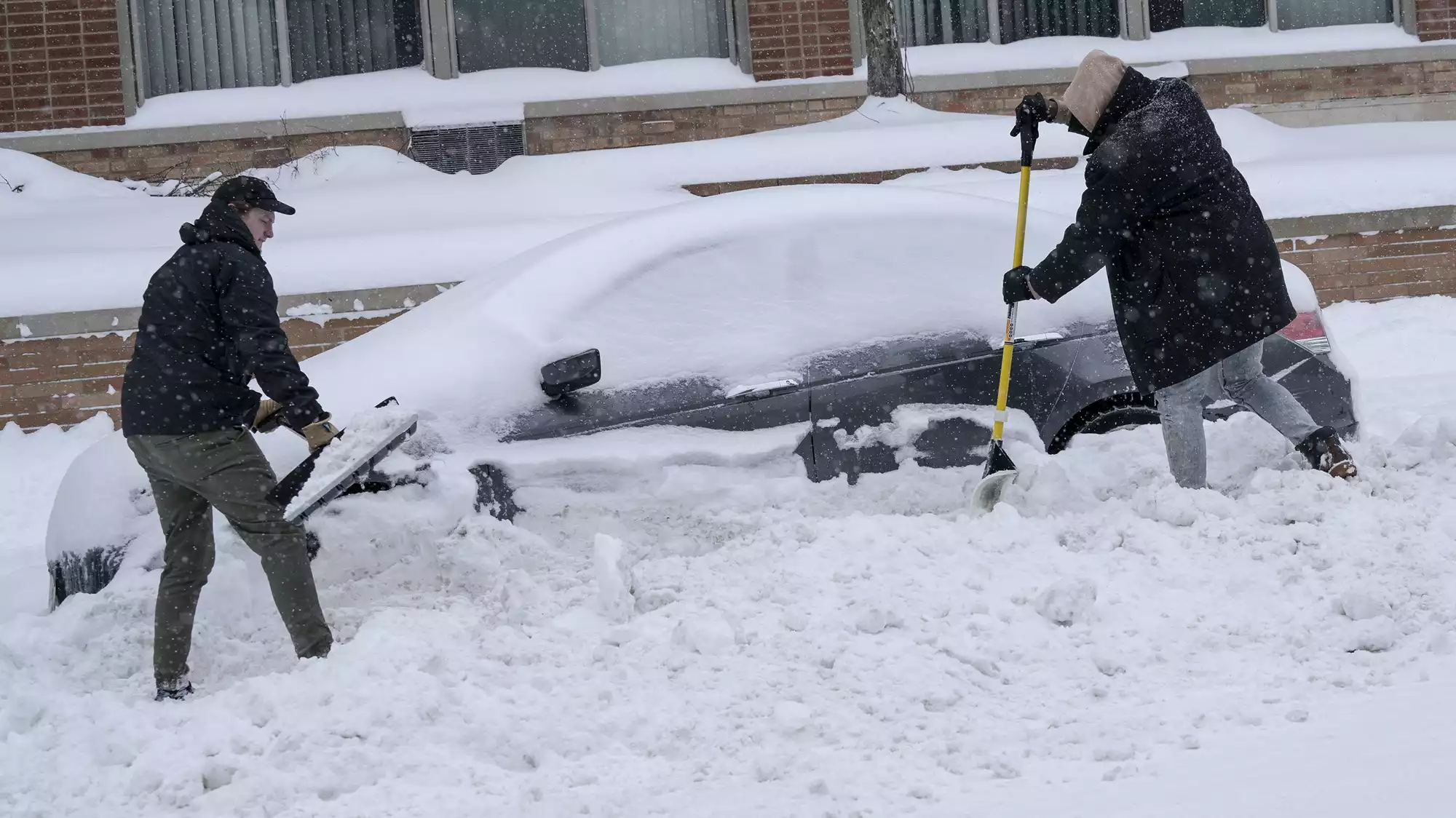
Jake Gunderson, left, helps Joshua James dig his car out of the snowbank on Lagoon Ave. in Uptown. James wanted to get the car clear before the snow left by a plow turned to ice on Thursday.
Judy Griesedieck for MPR News
Go Deeper.
Create an account or log in to save stories.
Like this?
Thanks for liking this story! We have added it to a list of your favorite stories.
Audio transcript
[MUSIC PLAYING] CATHY WURZER: And as I have said, we've almost reached the other side of this week's snowstorm, but there are still blustery winds to contend with, Arctic temperatures, and guess what, another storm system for Monday. MPR news meteorologist Sven Sungaard is here to break down the storm's biggest impacts and tell us what's next.
Well, there was some bellyaching earlier this morning as you know, Sven--
SVEN SUNDGAARD: [LAUGHS]
CATHY WURZER: Folks got up and said, wait a minute, where's all the snow? I thought we were going to get 20 inches. And it's like, no, not really. However, some places came pretty close.
SVEN SUNDGAARD: Yeah. And as we talked about yesterday, there was going to be this burst late in the night and early this morning. And it really delivered. Just between 6:00 and 7:00 AM this morning at MSP we got 2 inches of snow just in that hour, and really from about 4:00 to 8:00 AM those snowfall rates were at 1 to 2 inches per hour and the heaviest band set up over the South Metro.
And that's where the totals are really coming in here at 19 inches in Apple Valley, 17 inches though to the North in Cambridge, 16.9 in Burnsville, there's a 16.7 inch report Northeast Minneapolis, also Eagan, Savage at 16 inches, southwestern Minnesota not to be left out, 15 inches in Slaton, and picked up about a foot in the Rochester area.
Snow is still falling across parts of Northeastern Minnesota along the North Shore where a few more inches could fall from Duluth and especially along the South Shore where the Northeast winds are really roaring. We're talking about waves over the big lake that are over 12 feet here this morning and afternoon.
CATHY WURZER: Well, that's pretty impressive. Say, where then does this storm rank in terms of overall snowfall totals?
SVEN SUNDGAARD: That is the question still because we are still waiting for the official observation at the Minneapolis Saint Paul International Airport. They do that about noon, so it should be coming any minute. I'm refreshing my screens like a lot of people. The guess is it's probably going to come in between 13 and 15 inches.
And so that will really matter because 13 inches puts it back in the top 24 snowfalls, which would be the second top 24 snowfall we've had this season. And that's only the fourth time that's ever happened, where we've had to top 24 snowfalls in one season. The first time that it's happened in 38 years. So it's still a big snowfall however you look at it. Whether you've got a foot, or you got the 19 inches, definitely quite a bit out there.
CATHY WURZER: It is. But I'm wondering, with all that activity that was happening yesterday around Illinois Chicago, Saint Louis, did that suck some of the moisture in that direction instead of having it settle over us?
SVEN SUNDGAARD: Yeah. It did cut off the moisture. So we had the area of snow that had started to redevelop late yesterday afternoon that we all experienced, and then this wave we were watching out of Colorado. That was a tense band of snow that really filled in and that's what gave us the burst early this morning. We were expecting that to fill in a little bit more and had that happen, we would have been looking at even higher totals this morning that would have been more widespread totals that would have been over 15 inches instead of the more spotty 16, 17, 18 inch amounts.
CATHY WURZER: OK. So it looks like behind this system some pretty decently cold air.
SVEN SUNDGAARD: Yeah. Brief shot but potent cold air. It's been below 0 every morning this week in northern Minnesota, and now it's the rest of the states turn, that's what's going to be moving in. So Northwest winds blowing that in. Probably low 20s below 0 in Northwestern Minnesota early tomorrow, even in the Twin Cities single digits below 0, teens below 0 in Northeastern Minnesota, and the wind chill of course, is going to be a little bit cooler.
The winds will be lighter by tomorrow morning, just about 5, 10 miles an hour. But that's enough where we're talking windchills in the mid 30s below 0 out West, and probably teens below 0 in southeastern Minnesota in the Twin Cities and highs only in the low teens tomorrow, single digit highs in Northeastern Minnesota, and it may stay below 0 through the day in the Red River Valley.
CATHY WURZER: Oh, yes. But we get to warm up this weekend.
SVEN SUNDGAARD: Yeah. 20s are back tomorrow for Southern Minnesota, teens to the North. And it looks as though the Southern half of the state should be above freezing mid-thirties Sunday. We're going to have sunshine too tomorrow, Saturday, and I think most of Sunday. And close to 40 on Monday, which is actually going to throw a wrench in the next storm system.
CATHY WURZER: Oh, great. I did, I did know that you were going to talk about this just--
SVEN SUNDGAARD: I know.
CATHY WURZER: I almost hate to bring this up. Are we talking about what ice and snow?
SVEN SUNDGAARD: Yeah, it could be all of the above and rain. It looks like in Southern Minnesota, including the Twin Cities this will start as rain because of the warm temperatures, could have an icy mixture between the Twin Cities and Duluth. This is all very fluid, of course, still. But it looks like heavy snow is what's going to set up in the Northeastern part of the state several inches or more for Duluth and the North Shore, so it might be their turn. And then turning over to some snow in the Twin Cities and southeastern Minnesota. And then there's another system maybe behind that for Wednesday. So it's going to be an active pattern still.
CATHY WURZER: Oh. But wait, there's more. OK. Sven, thank you. I appreciate. It really did a great job with this whole storm system over many days. Thank you for your work.
SVEN SUNDGAARD: You're very welcome, Cathy.
CATHY WURZER: Sven Sundgaard, our meteorologist.
Download transcript (PDF)
Transcription services provided by 3Play Media.
