
Nearly a Minnesota exclusive
Go Deeper.
Create an account or log in to save stories.
Like this?
Thanks for liking this story! We have added it to a list of your favorite stories.


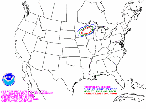
Early Saturday morning, as the snow was about to accumulate rapidly in Minnesota, here was the posted snowfall potential from the National Center for Environmental Prediction (NOAA). As you can see by comparing this to the previous graphical snowfall observations, the highest probability of greater than eight inches (shown in red contour) was vey exclusive to Minnesota and a small part of northwest Wisconsin.
A daily record snowfall total of 7.7 inches for November 13th was measured at the Twin Cities International Airport on Saturday. Meanwhile the Duluth International Airport measured a record 7.1 inches on the 13th and a record 3.8 inches on the 14th.
With temperatures holding nearly steady on Sunday and the relatively mild ground there was considerable compression of the fresh snow. This morning at the Twin Cities Airport the snow depth was down to three inches. In Chanhassen, where more than ten inches of snow was measured on Saturday, the snow depth at 6am was down to five inches.
I received an email last night from my colleague at Target Field that he has put the grounds keeping of the immaculate playing surface to rest for the season. They shoveled about seven inches off the plaza. Is it too ambitious to look forward to opening day on April 8, 2011?
Turn Up Your Support
MPR News helps you turn down the noise and build shared understanding. Turn up your support for this public resource and keep trusted journalism accessible to all.

