
Storm two in the que
Go Deeper.
Create an account or log in to save stories.
Like this?
Thanks for liking this story! We have added it to a list of your favorite stories.


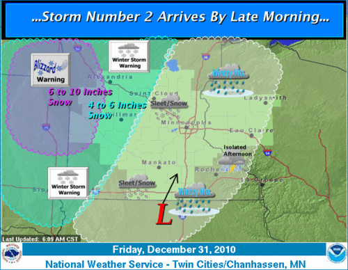
The path of the second low pressure center is now projected slightly further west. This puts the heaviest snow in western Minnesota and the Dakotas later today and tonight.
Looking for the silver lining, we are in the midst of a little lull. Winds have dropped off in western Minnesota this morning and only a small patch of residual snow was depicted on radar in far northeast Minnesota. However, temperatures have fallen sharply from readings in the the forties last evenng over southeast Minnesota.
Moisture is gathering in Iowa at daybreak. Snow will breakout in southwest Minnestoa and southeast South Dakota during the late morning. A mixture of snow, sleet and freezing rain is on tap for the Twin Cities
Turn Up Your Support
MPR News helps you turn down the noise and build shared understanding. Turn up your support for this public resource and keep trusted journalism accessible to all.
With the track of the low moving further west, the bulk of the moisture will miss the Twin Cities and western Wisconsin. Total snowfall accumulation around the metro may approach an inch or two. Let's see what falls from the sky this afternoon.
NOAA's graphic on the most likely area to receive eight inches of snow or more with this storm.

