
Brace yourself! Wind and snow usher in 2012
Go Deeper.
Create an account or log in to save stories.
Like this?
Thanks for liking this story! We have added it to a list of your favorite stories.


A developing weather system over Minnesota and Iowa today is expected to generated precipitation in the form of snow and rain mixed with snow. All snow is likely later this evening in the Twin Cities.
The National Weather Service has issued a Winter Storm Warning for tonight through early Sunday due the prospects of strong winds and blowing snow.
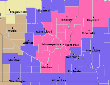
From the National Weather Service in Chanhassen. The pink shaded area is for snow accumulations of two to three inches accompanied by winds as strong as 45 mph. The area shaded in blue is for lesser amounts of snow but still very strong winds.
Turn Up Your Support
MPR News helps you turn down the noise and build shared understanding. Turn up your support for this public resource and keep trusted journalism accessible to all.
Here's your link to the latest storm updates from the Chanhassen NWS Office.
Travel could be very difficult due to low visibilities in blowing snow and strong winds, as well as icy roadways.
Here's a look at the GFS model for sustained winds and temperatures on New Years morning.
Button down for winds gusting to 45 mph on Sunday. Wind chill readings will be sub zero.
CE

