
Last gasp for serious heat; cool front arrives this weekend
Go Deeper.
Create an account or log in to save stories.
Like this?
Thanks for liking this story! We have added it to a list of your favorite stories.


I have a thermometer outside the west metro weather lab that is 4 feet off the ground, over grass, in direct sunshine. It read 131 degrees (not the heat index) at 3:30 p.m. Meanwhile, many thermometers in the metro area, properly shaded, were pushing the mercury to 100 degrees or more. This is serious heat, not often experienced in our neck of the woods. The dewpoints in the lower 70s make conditions almost unbearable.
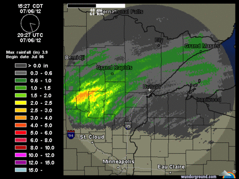
In northern Minnesota, cooler air has already brought relief. A generous rain also fell in the lake country region in the past 18 hours.
Rainfall totaling up to 3 inches likely accumulated around the Brainerd Lakes area.
Turn Up Your Support
MPR News helps you turn down the noise and build shared understanding. Turn up your support for this public resource and keep trusted journalism accessible to all.
Estimated rainfall from the Duluth Doppler radar. Source: NOAA/Weather underground.
This satellite image clearly identifies the different air masses. At 3 p.m. CDT it was 64 degrees in Duluth, Staples and Longville. Minneapolis, St. Paul and Winona sat at 100 degrees. It was 101 at Flying Cloud Airport in Eden Prairie.
NOAA visible satellite image at 245 p.m. CDT. Source: College of Dupage.
Thunderstorms may ignite shortly near Granite Falls. The Storm Prediction Center has a risk for severe weather for later this afternoon and tonight.
NOAA SPC issued at 3 p.m. CDT
This outlook defines the threat for large hail and damaging winds. There is a potential for isolated tonadoes.
Once we get this cool front to sag south of Minnesota overnight, we will see more comfortable temperatures for Saturday and Sunday afternoon. I'm thinking this front does not have a lot of giddyup. We could experience highs in the mid 80s on Sunday afternoon in southern Minnesota.
Source: NOAA NAM and College of Dupage
The NAM forecast paints temperatures in the 80s for 1 p.m. CDT on Sunday. The winds will be light as well on Sunday afternoon.
At 4 p.m. CDT it is 101 degrees at the Minneapolis-St. Paul International Airport and 102 degrees in Winona. The record for today in the Twin Cities is 104 set in one hot summer of 1936.
Craig Edwards

