
Isaac forecast to become a hurricane later today, taking aim at New Orleans
Go Deeper.
Create an account or log in to save stories.
Like this?
Thanks for liking this story! We have added it to a list of your favorite stories.


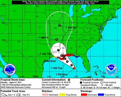
The latest advisory from the National Hurricane Center from 1 p.m. CDT confirms Tropical Storm Isaac has winds of 65 mph. It's moving to the northwest at about 15 mph.
Landfall could take place in close proximity to New Orleans late on Tuesday with the lashing continuing through Tuesday night.
Turn Up Your Support
MPR News helps you turn down the noise and build shared understanding. Turn up your support for this public resource and keep trusted journalism accessible to all.
IR satellite image NOAA at 12:15 p.m. CDT
From the National Hurricane Center:
A HURRICANE WARNING IS IN EFFECT FOR...
* EAST OF MORGAN CITY LOUISIANA TO DESTIN FLORIDA...INCLUDING
METROPOLITAN NEW ORLEANS...LAKE PONTCHARTRAIN...AND LAKE MAUREPAS
MAXIMUM SUSTAINED WINDS ARE NEAR 65 MPH...100 KM/H...WITH HIGHER
GUSTS.
SOME STRENGTHENING IS FORECAST AND ISAAC IS EXPECTED TO BECOME A HURRICANE BEFORE REACHING THE NORTHERN GULF COAST.
Both the path and the intensity still have some uncertainty. It currently appears that the city of New Orleans needs to be prepared to be battered by this tropical storm. Landfall could occur early Tuesday evening.
Excessive rainfall is a serious threat as the computer models slow the inland movement of the tropical storm on Tuesday night and Wednesday.

