
Very heavy rains produce flash flooding
Go Deeper.
Create an account or log in to save stories.
Like this?
Thanks for liking this story! We have added it to a list of your favorite stories.


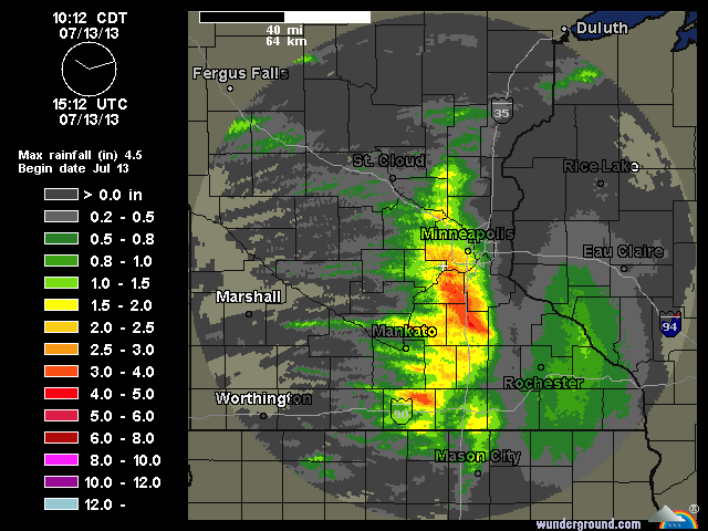
Rainfall totals exceeded 4 inches across southern sections of the Twin Cities metro overnight and early this morning. Some of the heaviest totals were from Eden Prairie to Burnsville.
The greatest accumulation of rain (6.69 inches) was reported three miles south of Crystal Bay in Scott County, south of the Twin Cities.
Flash flooding created havoc from the Twin Cities to the Iowa border, with the heaviest rain producing flash flooding from the south metro through Northfield and west of Albert Lea.
More showers and thunderstorms were already developing in southwest Minnesota this morning.
Turn Up Your Support
MPR News helps you turn down the noise and build shared understanding. Turn up your support for this public resource and keep trusted journalism accessible to all.
I suggest you keep a close watch on the Doppler radar throughout the afternoon and tonight. More heavy rains are possible as a warm front sets up through central Minnesota.
The graphic above paints a vivid image of where heavy rains and flash flooding occurred.
Rainfall reports from the Chanhassen NWS Office can be found here.

