Flood updates: Guardsmen leave Int'l. Falls; emergency declaration extended

As flood waters around the state keep rising, Gov. Mark Dayton has extended an emergency declaration for 35 counties for another 30 days, saying he expects a new $3 million disaster assistance account will be exhausted.
Related coverage
• 12 ways to stay safe after a flood
• Check the forecast in your area
• Follow Updraft for more weather news
• Why sump pumps may cause sewage backups
The governor, who's been touring flooded areas of the state, said it may take several weeks to assess the flood damage caused by recent heavy rains. Local officials will have to wait until the waters recede to compile the damage estimates, he added.
"There's a lot of human suffering and it's very painful," he said. "Yet, people are very resilient and very strong and to see the help that people give their neighbors and friends and even complete strangers is very extraordinary."
Create a More Connected Minnesota
MPR News is your trusted resource for the news you need. With your support, MPR News brings accessible, courageous journalism and authentic conversation to everyone - free of paywalls and barriers. Your gift makes a difference.
Dayton said it may be necessary to call a special legislative session to approve more disaster aid, and the state will probably qualify for federal disaster assistance.
State public safety officials say more than half of all Minnesota counties felt the damage of recent storms and flooding.
Even though the rain has stopped for now, water levels on lakes and rivers are still rising, said Joe Kelly, deputy director of homeland security and emergency management.
Kelly said the latest heavy rainfall reminds him of the major floods in 1997. "It's not unprecedented," he said, "but it certainly is significant that we have this many counties that are being impacted by a weather system."
The Mississippi River is expected to reach its highest level in St. Paul and downstream in Hastings later this week.
State of emergency in St. Paul
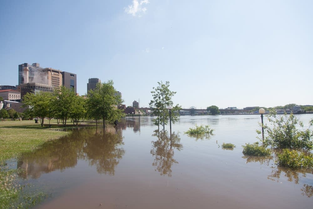
St. Paul Mayor Chris Coleman has declared a state of emergency as the city braces for the worst flooding it's seen since 2001.
The Mississippi River is predicted to rise another two feet before cresting in St. Paul on Thursday. At the peak, waters will reach a projected six-and-a-half feet above flood stage.
The disaster declaration would allow the city to seek reimbursement for flood related expenses if the federal government releases relief funds to Minnesota. St. Paul projects it will spend an estimated $1.7 million in preparation for flooding.
Fourteen cities and counties have made similar declarations.
Waterville inundated
Kelly said the city of Waterville in Le Sueur County is experiencing some lake flooding that could endanger a water treatment facility. The aptly named city sits between Lake Tetonka and Lake Sakatah.
Officials with the city say volunteers have filled and placed about 20,000 sandbags around buildings to protect them from encroaching water.
Fire chief Chris Meskan says several homes are surrounded by water from nearby lakes, and a few will be completely destroyed. The city has closed four streets and parts of three others due to the flooding.
Meskan says right now, water levels are holding steady and he's not looking for more help sandbagging.
"If we would get a heavy rain, then we would be starting all over again and we would look for volunteers. But as of right now, we're set - we're kind of holding our own right now," Meskan said.
Meskan says the city's water treatment plant is stressed, but is keeping up with the heavy demand. However, Meskan is asking residents to stay out of the flood waters in case of contamination from debris.
Frustration in Scott County

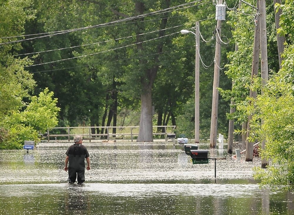
Evacuated residents of a flooded town in southeastern Minnesota have learned it could be as much as two weeks before they can return to their homes.
Electrical and phone service are out in Blakeley, a town of about 500 that was evacuated last week because of the rising Minnesota River. Roads and highways around the town have been washed out, damaged by mudslides and others are blocked by fallen trees. County engineer Mitch Rasmussen told residents at a town meeting Monday night that some of the roads will have to be rebuilt.
Scott County Sheriff Kevin Studnicka said about 75 people have been displaced by the flooding.
Mudslides and flood waters have blocked and damaged roads, making it difficult for power crews to get in to start making repairs, he said.
An Xcel Energy spokesman says work crews still can't get into Blakeley. Thirty-three customers there are without power.
Kayaker rescued from Mississippi

Crews rescued a kayaker who was stranded on a downed tree in the Mississippi River near St. Cloud after being called to the Sauk Rapids Bridge around 1:30 p.m. Monday.
Twenty-one-year-old Anita Henningsgaard of St. Cloud and her fellow kayaker were wearing lifejackets when the current carried Henningsgaard into the path of a fallen tree. Using a rope, a deputy and a St. Cloud firefighter helped Henningsgaard walk along the trunk of the tree to safety.
The St. Cloud Times reports Henningsgaard walked away on her own and didn't require first aid.
Stearns County Sheriff John Sanner says people should stay out of the water until normal levels and current return.
Stillwater Lift Bridge closed
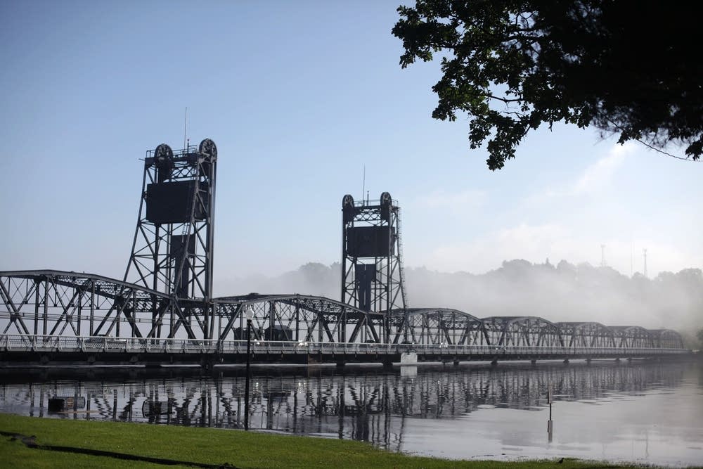
The Stillwater Lift Bridge connecting Minnesota Highway 36 and Wisconsin Highway 64 will be closed to traffic in both directions indefinitely to traffic at 10 a.m. Monday because of high water on the St. Croix River. MnDOT says drivers should use Interstate 94 or Highway 243 as detour routes.
The National Weather Service says the river at Stillwater will continue to rise this week by more than a foot and crest sometime late on Friday. The prediction from the North Central River Forecast Center says the St. Croix may not start to drop significantly until early next week.
Road closures: MnDOT's updated list
National Guard heads out of International Falls
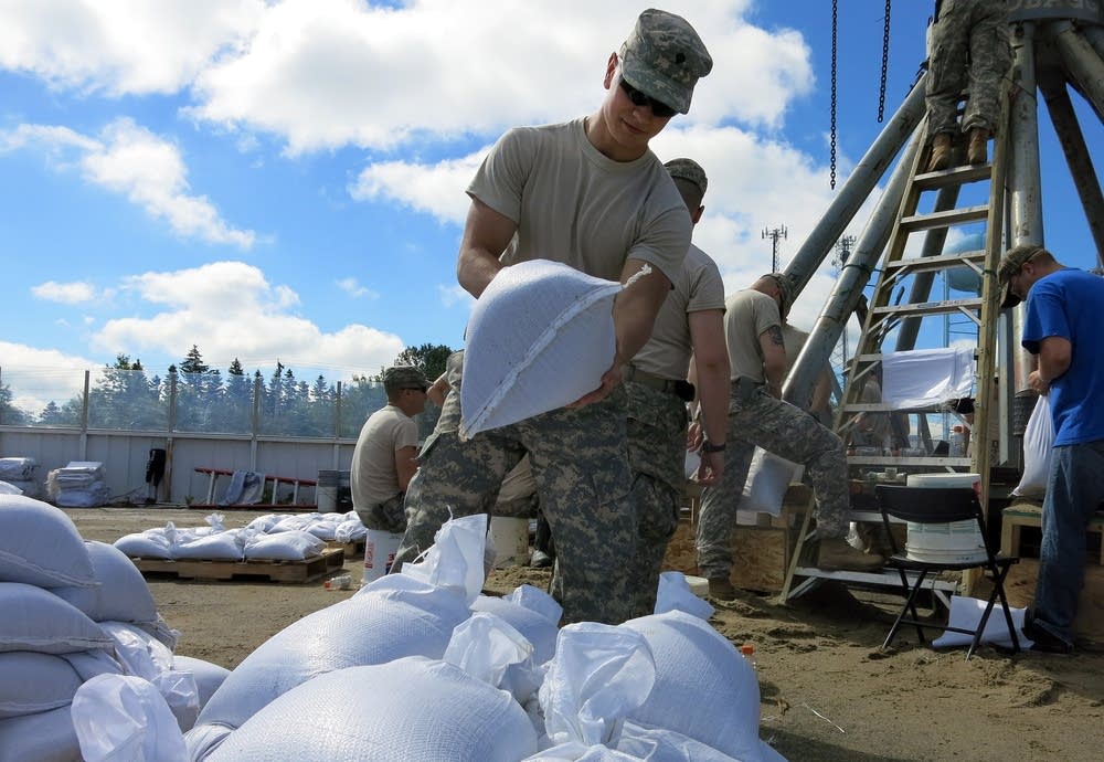
National Guard soldiers are packing up their gear and leaving International Falls after four days filling sandbags and building temporary dikes.
More than 100 soldiers from Troop C, 1-94th Cavalry helped local residents as heavy rains pushed water on the Rainy River and Rainy Lake into record level flooding.
The soldiers filled and hefted enough sandbags to bring the area out of immediate risk.
"I wouldn't say we have it licked," said Koochiching County Chairman Rob Ecklund. "I'd say we're cautiously optimistic that we have the flooding under control."
When the National Guard arrived in the city Thursday night, Rainy Lake was pushing into shoreline lawns already at flood stage and predicted to rise another 16 inches. For a while the water was rising faster than the sandbag dikes. Now the lake is only expected to rise another five inches, and Guard-built dikes are plenty tall to handle such levels.
All told, homes on Rainy Lake and Rainy River are surrounded by something over 300,000 sandbags according to Ecklund. Kerry Park, previously manned by as many as 1000 volunteers is now empty.
In case of another thunderstorm, two sandbag filling machines are still set up, and Koochiching County still has 12,000 sandbags in reserve.
Medical Center mudslide debris cleared
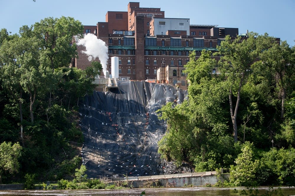
West River Road beneath the University of Minnesota Medical Center in Minneapolis has been cleared of debris after a mudslide there last week. The road remains closed. The mudslide area has now been protected from further rain with a special fabric.
A Fairview Health Services spokeswoman said some equipment has been removed from behind the hospital building, near the mudslide site. "We received approval to switch back to our primary oxygen source and have done so," said Cindy Fruitrail.
"That means we need to empty the temporary oxygen tank that was brought onsite last Friday, so it can be removed," she said. When the tank is emptied on Tuesday morning, "it will again create some noise and a cloud behind the hospital."
Rain in the forecast

Look for showers and a few thunderstorms in northern Minnesota this morning, then more numerous showers and scattered thunderstorms around the state this afternoon into this evening. Some small hail is possible following afternoon heating, but severe weather is not expected.
Forecast models continue to show the likelihood of more rain later this week. The best chance for heavy rain, along with the possibility of severe weather, could be Friday night and Saturday, mainly for the southern half of Minnesota.
A long-range seven-day forecast paints a bullseye of possible precipitation right over Minnesota. If this model works out, most of the state would receive well over two inches of rain during the next week.