
Winter storm warning this afternoon through Saturday
Go Deeper.
Create an account or log in to save stories.
Like this?
Thanks for liking this story! We have added it to a list of your favorite stories.


First we'll have snow, and lots of it. Then we'll see very cold temps and frigid wind chills.
Winter storm warning
The National Weather Service has issued a winter storm warning for much of central and southern Minnesota, including the Twin Cities, that runs from noon today to 6 p.m. Saturday:
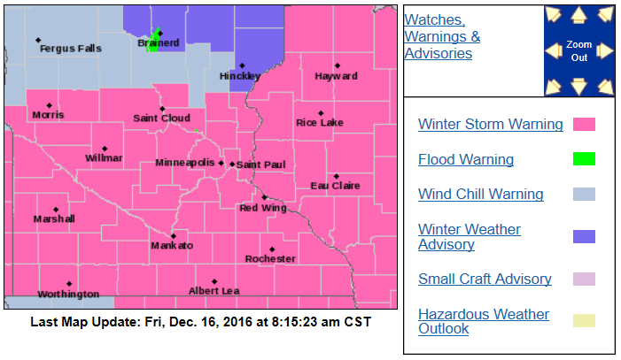
The warning is for significant snow amounts from this afternoon through the overnight hours, followed by blowing and drifting snow on Saturday.
Turn Up Your Support
MPR News helps you turn down the noise and build shared understanding. Turn up your support for this public resource and keep trusted journalism accessible to all.
A wind chill advisory goes into effect at 6 p.m. Saturday and runs to noon Sunday for the same area that has the winter storm warning. Wind chills in the minus 25 to minus 40 degree range are expected Saturday into early Sunday.
There is a wind chill warning for northwestern and west-central Minnesota from Saturday through noon on Sunday for wind chill temps from minus 30 to minus 45 degrees.
Here are some winter storm warning details, from the Twin Cities NWS office:
URGENT - WINTER WEATHER MESSAGE
NATIONAL WEATHER SERVICE TWIN CITIES/CHANHASSEN MN
404 AM CST FRI DEC 16 2016
...HEAVY SNOWFALL EXPECTED FRIDAY AFTERNOON THROUGH SATURDAY
MORNING...
...BITTERLY COLD WIND CHILLS SATURDAY NIGHT INTO SUNDAY...
.OCCASIONAL LIGHT SNOW AND FLURRIES EARLY THIS MORNING WILL GIVE
WAY TO STEADIER AND HEAVIER SNOW DURING THE LATE MORNING AND
AFTERNOON HOURS. THE SNOW WILL BE LOCALLY HEAVY DURING THE LATE
AFTERNOON AND EVENING... AND WILL BEGIN TO TAPER OFF SATURDAY
MORNING. SNOWFALL AMOUNTS OF 6 TO 11 INCHES ARE LIKELY WITH THIS
STORM ACROSS SOUTHERN MINNESOTA AND WEST CENTRAL WISCONSIN. AREAS
ALONG AND SOUTH OF A LINE FROM APPLETON...TO LITCHFIELD...TO THE
TWIN CITIES...TO EAU CLAIRE WILL LIKELY SEE THE HEAVIEST SNOW.
SOME BLOWING AND DRIFTING SNOW ALONG WITH FRIGID TEMPERATURES
WILL FOLLOW THE SNOW LATER SATURDAY AFTERNOON INTO SUNDAY. WIND
CHILLS WILL PLUNGE INTO A RANGE FROM 35 TO 45 BELOW ZERO ACROSS
MUCH OF THE AREA BY SATURDAY EVENING... AND REMAIN IN THAT RANGE
INTO SUNDAY MORNING.
MNZ059>063-066>070-074>078-082>085-091>093-WIZ023-024-161900-
/O.NEW.KMPX.WC.W.0002.161218T0000Z-161218T1800Z/
/O.CON.KMPX.WS.W.0006.161216T1800Z-161218T0000Z/
WRIGHT-HENNEPIN-ANOKA-RAMSEY-WASHINGTON-MCLEOD-SIBLEY-CARVER-
SCOTT-DAKOTA-BROWN-NICOLLET-LE SUEUR-RICE-GOODHUE-WATONWAN-
BLUE EARTH-WASECA-STEELE-MARTIN-FARIBAULT-FREEBORN-ST. CROIX-
PIERCE-
INCLUDING THE CITIES OF...MONTICELLO...MINNEAPOLIS...BLAINE...
ST PAUL...STILLWATER...HUTCHINSON...GAYLORD...CHASKA...SHAKOPEE...
HASTINGS...NEW ULM...ST PETER...LE SUEUR...FARIBAULT...RED WING...
ST JAMES...MANKATO...WASECA...OWATONNA...FAIRMONT...BLUE EARTH...
ALBERT LEA...HUDSON...RIVER FALLS...PRESCOTT
404 AM CST FRI DEC 16 2016
...WINTER STORM WARNING REMAINS IN EFFECT FROM NOON TODAY TO 6 PM
CST SATURDAY...
...WIND CHILL WARNING IN EFFECT FROM 6 PM SATURDAY TO NOON CST
SUNDAY...
THE NATIONAL WEATHER SERVICE IN TWIN CITIES/CHANHASSEN HAS ISSUED
A WIND CHILL WARNING...WHICH IS IN EFFECT FROM 6 PM SATURDAY TO
NOON CST SUNDAY.
* EXPECT STEADIER SNOW TO DEVELOP AROUND NOON AND THEN DIMINISH
ON SATURDAY.
* THE HEAVIEST SNOWFALL RATES WILL OCCUR BETWEEN 6 PM THIS EVENING
AND MIDNIGHT.
* TOTAL SNOW ACCUMULATIONS OF 6 TO 10 INCHES ARE EXPECTED.
* WINDS GUSTING AS HIGH AS 30 MPH WILL CAUSE AREAS OF BLOWING AND
DRIFTING SNOW ON SATURDAY. IN ADDITION...AREAS OF POOR
VISIBILITY ARE EXPECTED.
* EXPECT WIND CHILLS TO RANGE FROM 25 BELOW ZERO TO 45 BELOW
ZERO BETWEEN 6 PM SATURDAY AND NOON SUNDAY...WITH THE COLDEST
WIND CHILLS OCCURRING AROUND 6 AM SUNDAY.
* THE DANGEROUSLY COLD WIND CHILLS WILL CAUSE FROSTBITE IN AS
LITTLE AS 10 MINUTES TO EXPOSED SKIN.
PRECAUTIONARY/PREPAREDNESS ACTIONS...
A WIND CHILL WARNING MEANS THE COMBINATION OF VERY COLD AIR AND
THE WIND WILL CREATE DANGEROUSLY LOW WIND CHILL VALUES. FROST
BITE CAN OCCUR QUICKLY AND EVEN HYPOTHERMIA OR DEATH IF
PRECAUTIONS ARE NOT TAKEN.
A WINTER STORM WARNING FOR SNOW MEANS SEVERE WINTER WEATHER
CONDITIONS ARE EXPECTED. IF YOU MUST TRAVEL...KEEP AN EXTRA
FLASHLIGHT...FOOD AND WATER IN YOUR VEHICLE IN CASE OF AN
EMERGENCY. THE LATEST ROAD CONDITIONS FOR THE STATE YOU ARE
CALLING FROM CAN BE OBTAINED BY CALLING 5 1 1.
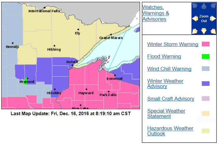
A winter weather advisory for lesser snow amounts and difficult travel conditions includes parts of central and northeastern Minnesota:
Snow amounts
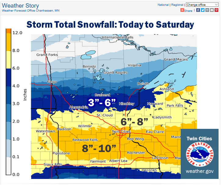
The Twin Cities metro area and much of southern Minnesota could see 2 to 3 inches of snow by 6 p.m., and an additional 4 to 6 inches overnight into early Saturday morning.
Here are possible storm totals, courtesy of the Twin Cities office of the National Weather Service:
The winds pick up on Saturday, causing some blowing and drifting of the snow, especially in open areas.
Here is the simulated radar from noon today to noon Saturday, from the National Oceanic and Atmospheric Administration’s 4 km resolution North American Mesoscale forecast model:
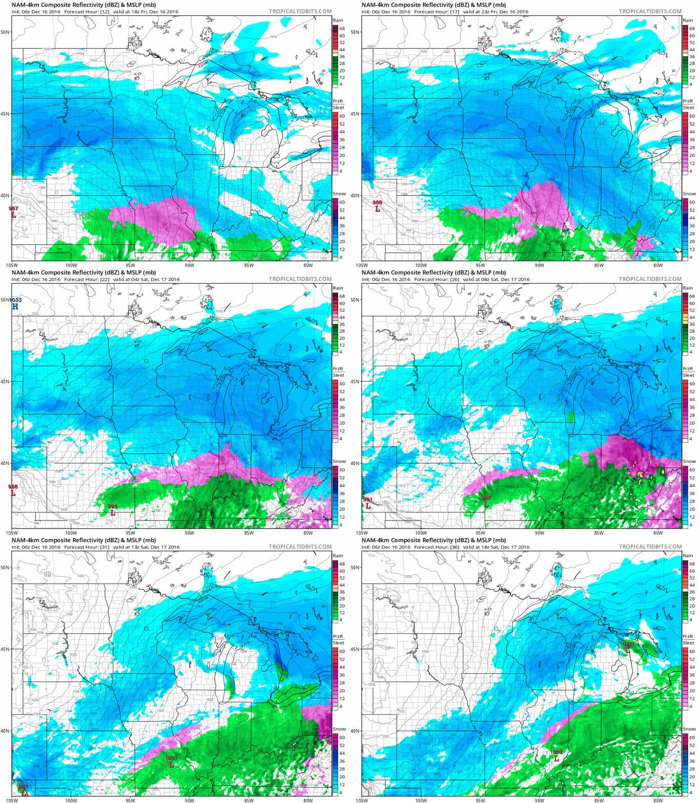
By the way, ignore the color chart for snow on the lower right. It shows the colors used for different signal strengths that return to the radar, not inches of snow!
You can see updated winter storm information on our severe weather live blog.
Please share your photos and storm reports with our Public Insight Network and we can include them in our coverage.
The Minnesota Department of Transportation has current road conditions.
Cold and colder
Highs will reach the teens over southern Minnesota today, then some much colder air moves in on Saturday and Saturday night. Falling temps are expected on Saturday.
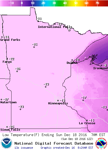
Low temps will be colder than 20 below zero over much of Minnesota late Saturday night/early Sunday morning:
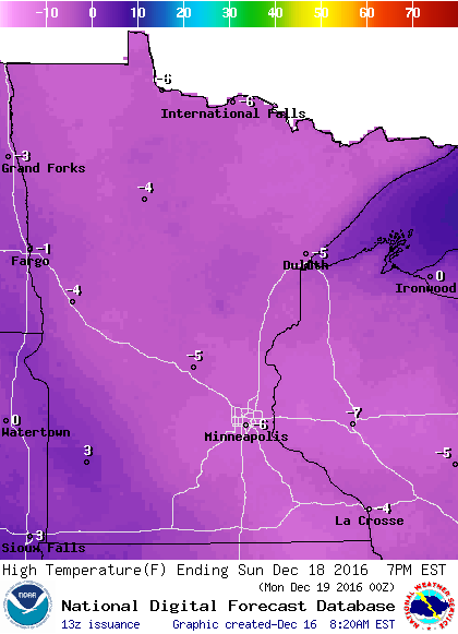
Highs Sunday will be below zero over most of Minnesota:
Highs will rebound into the teens over southern Minnesota on Monday, then we see upper 20s Tuesday afternoon:
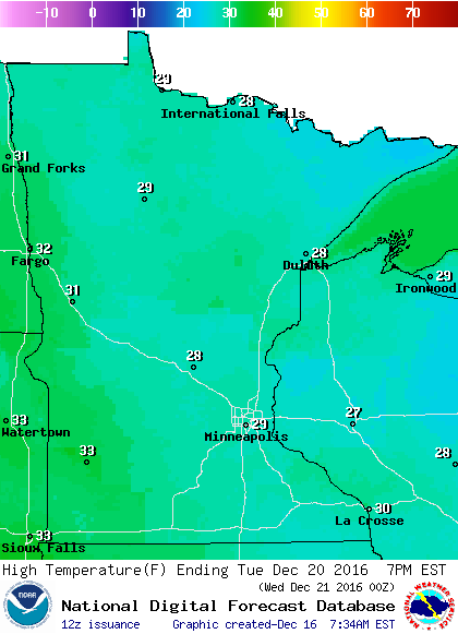
Those Tuesday high temps will be a bit above normal for this time of year, but not T-shirt weather.
Programming note
You can hear my live weather updates on Minnesota Public Radio at 7:35 a.m. and 4:35 p.m. each Saturday and Sunday.

