
Cold overnight and Sunday; wind chill warning
Go Deeper.
Create an account or log in to save stories.
Like this?
Thanks for liking this story! We have added it to a list of your favorite stories.


Brrrrrrr!
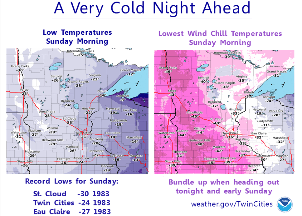
Minnesota will see low temperatures in the 20s below zero early Sunday morning.
Wind will combine with our very cold temperatures to give us dangerous wind chills Saturday night and Sunday morning.
Many spots will see wind chill readings in the -35 to -45 degree range. Some spots in western Minnesota could see wind chill temps close to -50.
Turn Up Your Support
MPR News helps you turn down the noise and build shared understanding. Turn up your support for this public resource and keep trusted journalism accessible to all.
Here's a summary from the Twin Cities office of the National Weather Service:
Wind chill warnings are in effect for most of Minnesota overnight and through Sunday morning:
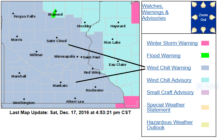
Here are some wind chill warning details, from the Twin Cities NWS office:
...WIND CHILL WARNING REMAINS IN EFFECT FROM 6 PM THIS EVENING TO
NOON CST SUNDAY...
* EXPECT WIND CHILLS TO RANGE FROM 25 BELOW ZERO TO 45 BELOW ZERO
BETWEEN 6 PM THIS EVENING AND NOON SUNDAY...WITH THE COLDEST
WIND CHILLS OCCURRING AROUND 6 AM SUNDAY.
* THE DANGEROUSLY COLD WIND CHILLS WILL CAUSE FROSTBITE IN AS
LITTLE AS 10 MINUTES TO EXPOSED SKIN.
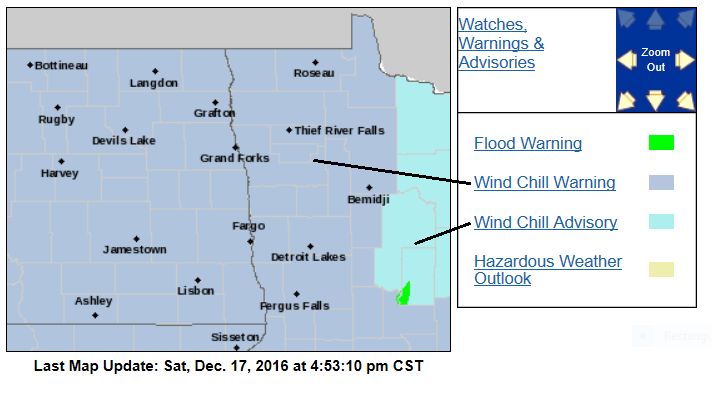
The wind chill warnings extend all the way to the Canadian border:
Sunday "high" temperatures will stay below zero all across Minnesota:
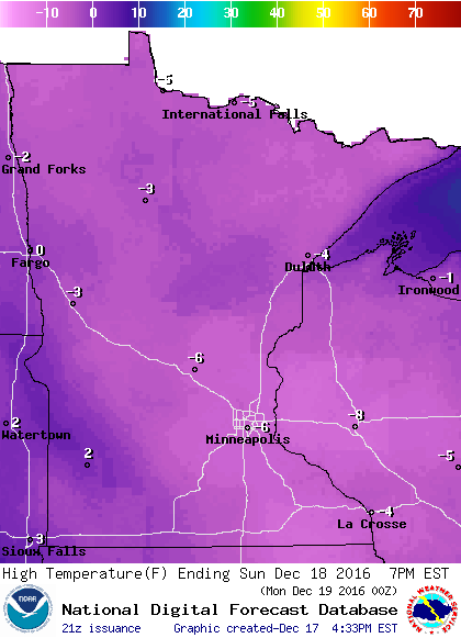
It's a good thing that the Vikings aren't playing outdoors on Sunday!
Frostbite tips
Our wind chill temperatures overnight and Sunday morning will be cold enough to cause frostbite on exposed skin in about 10 minutes.
According to the National Weather Service:
Frostbite can happen in minutes, especially on the extremities such as fingers, toes, nose and ears but can affect any area of exposed skin. If you suspect frostbite, immediately move inside to a heated location and begin warming the affected areas using warm water or body heat. Do not use hot water or radiant heat such as a fireplace since affected areas can be easily burned. Seek medical attention for severe frostbite.
Frostbite happens when the body's survival mechanisms kick in during extremely cold weather. To protect the vital inner organs, the body cuts circulation to your extremities: feet, hands, nose, etc., which eventually freeze. To avoid frostbite, stay inside during severe cold, especially when the windchill is -50°F or below. If you must go out, try to cover every part of your body: ears, nose, toes and fingers, etc. Mittens are better than gloves. Keep your skin dry. Stay out of the wind when possible. Drink plenty of fluids since hydration increases the blood's volume, which helps prevent frostbite. Avoid caffeine, alchohol and cigarette. Caffeine constricts blood vessels, preventing warming of your extremities. Alcohol reduces shivering, which helps keep you warm. Cigarettes shut off the blood flow to your hands.
Snowstorm recap
Our powdery blanket of new snow is beautiful to look at, but the snow was a real challenge for drivers who had to navigate slippery roads.
The official snowfall total from Friday afternoon through Saturday morning was 6.3 inches at Minneapolis-St. Paul International Airport.
Here's a map of new snowfall amounts, courtesy of the Twin Cities NWS office:
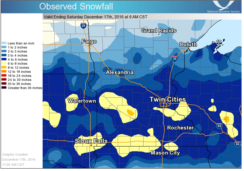
In the Twin Cities metro area, the highest totals were in the south, and included a report of 7 inches in Lakeville.
A list of other snow totals, courtesy of the Twin Cities office of the NWS:
The totals below are not necessarily the final amount for each location.
Thank you to all of our weather observers for making these reports possible.
Location Amount Time/Date Provider
Eau Claire 7.1 in 1020 AM 12/17 Official NWS
Lakeville 7.0 in 0900 AM 12/17
2 W Shakopee 7.0 in 0945 AM 12/17
Fairmont 6.8 in 0700 AM 12/17 COCORAHS
Menomonie 6.8 in 1100 AM 12/17
Richfield 1 WNW 6.8 in 0500 AM 12/17 COCORAHS
Bloomington 6.5 in 0800 AM 12/17
Bricelyn 6.5 in 0700 AM 12/17 COOP
2 WNW Richfield 6.5 in 0230 AM 12/17
North St Paul 1NNW 6.3 in 0848 AM 12/17 COCORAHS
Blue Earth 1S 6.1 in 0800 AM 12/17 COOP
Minneapolis St. Paul Airport 6.1 in 0600 AM 12/17 Official NWS
Victoria 1WSW 6.1 in 0700 AM 12/17 COCORAHS
2 ESE Apple Valley 6.0 in 0700 AM 12/17 COCORAHS
Baldwin 6.0 in 0700 AM 12/17 COOP
Dawson 6.0 in 0700 AM 12/17 COOP
Montevideo 1SW 6.0 in 0700 AM 12/17 COOP
1 SE Osceola 6.0 in 0900 AM 12/17
Rice Lake 6.0 in 1100 AM 12/17
River Falls 1S 6.0 in 0700 AM 12/17 COCORAHS
Rosemount 6.0 in 0800 AM 12/17
Spicer 3 WSW 6.0 in 0700 AM 12/17 COCORAHS
Victoria 2ENE 6.0 in 0800 AM 12/17 COCORAHS
Goodhue 5.9 in 0700 AM 12/17 COCORAHS
1 SE Burnsville 5.8 in 0800 AM 12/17
Edina 1SE 5.8 in 0725 AM 12/17 COCORAHS
Lakeville 2NNE 5.8 in 0700 AM 12/17 COCORAHS
Prior Lake 1WSW 5.8 in 0545 AM 12/17 COCORAHS
Redwood Falls 5.8 in 0630 AM 12/17 COOP
Credit River 5.7 in 0850 AM 12/17
Mendota Heights 2WNW 5.7 in 0700 AM 12/17 COCORAHS
Bloomington 1 ESE 5.6 in 0800 AM 12/17 COCORAHS
New Hope 1.9 S 5.6 in 0710 AM 12/17 COCORAHS
Apple Valley 3ESE 5.5 in 0700 AM 12/17 COCORAHS
Chaska 5.5 in 0615 AM 12/17 COCORAHS
Chaska 2NW 5.5 in 0300 AM 12/17 COOP
Farmington 2SE 5.5 in 0700 AM 12/17 COCORAHS
Golden Valley 5.5 in 0700 AM 12/17 COCORAHS
Lakeland 2WNW 5.5 in 0800 AM 12/17 COCORAHS
Mankato 4E 5.5 in 0700 AM 12/17 UCOOP
3 NE Stockholm 5.5 in 0830 AM 12/17
Stockholm 2NE 5.5 in 0800 AM 12/17 COCORAHS
NWS Chanhassen 5.4 in 0600 AM 12/17 Official NWS
1 SE Fridley 5.3 in 0815 AM 12/17
Roberts 5.2 in 0800 AM 12/17 COOP
Waconia 5.2 in 0700 AM 12/17 UCOOP
Watertown 5.2 in 0900 AM 12/17
1 SW Coon Rapids 5.1 in 1045 AM 12/17
Afton 1E 5.0 in 0845 AM 12/17 COCORAHS
Elk Mound 5.0 in 0730 AM 12/17 UCOOP
Hastings (L/D 2) 5.0 in 0600 AM 12/17 COOP
4 NNW Mendota Heights 5.0 in 0830 AM 12/17
Norwood/Young America 5.0 in 1240 AM 12/17
Red Wing 5.0 in 0800 AM 12/17
Red Wing 5.0 in 0800 AM 12/17 COOP
Red Wing (L/D 3) 5.0 in 0600 AM 12/17 COOP
River Falls 1SW 5.0 in 0700 AM 12/17 COCORAHS
4 N Rogers 5.0 in 0740 AM 12/17
4 WSW St. Paul 5.0 in 0830 AM 12/17
Watertown 5.0 in 0445 AM 12/17 COCORAHS
Willmar 5N 5.0 in 0600 AM 12/17 COOP
Winnebago 5.0 in 0741 AM 12/17 COOP
Woodbury 5.0 in 0700 AM 12/17 COCORAHS
Jim Falls 3 NW 4.9 in 0630 AM 12/17 COOP
Stillwater 2 SW 4.9 in 0700 AM 12/17 COCORAHS
White Bear Lake 4.9 in 0830 AM 12/17
2 NE Montrose 4.8 in 0945 AM 12/17
Plymouth 2ENE 4.8 in 0700 AM 12/17 COCORAHS
Rockford 4.7 in 0900 AM 12/17
Balsam Lake 4 SE 4.6 in 0700 AM 12/17 COCORAHS
Silver Lake 1NNW 4.6 in 0700 AM 12/17 COCORAHS
Annandale 4.5 in 0800 AM 12/17
Boyceville 3NNE 4.5 in 0700 AM 12/17 COCORAHS
Carver 4.5 in 0108 AM 12/17
Long Lake 4.5 in 0700 AM 12/17 COCORAHS
2 SW Maple Grove 4.5 in 0111 AM 12/17
Maple Plain 4.5 in 0900 AM 12/17
Newport 4.5 in 0745 AM 12/17
Saint Louis Park 2ESE 4.5 in 0700 AM 12/17 COCORAHS
St. Michael 1E 4.5 in 0800 AM 12/17 COCORAHS
Winthrop 4.5 in 0730 AM 12/17
Anoka 1SE 4.3 in 0700 AM 12/17 COCORAHS
Apple Valley 3SSE 4.3 in 0730 AM 12/17 COCORAHS
Minneapolis Dwtn (Miss R) 4.3 in 0600 AM 12/17 COOP
North St. Paul 1WNW 4.3 in 0700 AM 12/17 COCORAHS
Brooklyn Center 1E 4.1 in 0700 AM 12/17 COCORAHS
Bloomer 4.0 in 0800 AM 12/17 COOP
Chetek 2SE 4.0 in 0700 AM 12/17 COCORAHS
Cumberland 4.0 in 0920 AM 12/17
Golden Valley 4.0 in 0651 AM 12/17 COCORAHS
Isanti 4.0 in 0230 AM 12/17
Kimball 3N 4.0 in 0600 AM 12/17 COOP
Ladysmith 2WNW 4.0 in 0700 AM 12/17 COCORAHS
Mankato 4.0 in 0730 AM 12/17
Montgomery 3ENE 4.0 in 0600 AM 12/17 COCORAHS
North Branch 1WSW 4.0 in 0800 AM 12/17 COCORAHS
Orrock 2SE 4.0 in 0700 AM 12/17 COCORAHS
Stillwater 1NE 4.0 in 0751 AM 12/17 COCORAHS
Nerstrand 4E 3.8 in 0700 AM 12/17 COCORAHS
North Branch 1 NNW 3.8 in 0600 AM 12/17 COCORAHS
Roseville 3.8 in 0700 AM 12/17 COCORAHS
Sveadahl 5NNW 3.6 in 0715 AM 12/17 COCORAHS
Ellendale 3.5 in 0700 AM 12/17 COCORAHS
Le Center 5NNW 3.5 in 0800 AM 12/17 COCORAHS
Milaca 3.5 in 0730 AM 12/17 COOP
8 NE Myrtle 3.5 in 0721 AM 12/17
New Ulm 3SE 3.5 in 0555 AM 12/17 COOP
Rush City 3 NE 3.5 in 0700 AM 12/17 COCORAHS
St. Cloud (SCSU) 3.5 in 0500 AM 12/17 UCOOP
Veseli 1W 3.5 in 0500 AM 12/17 COCORAHS
Waseca 1NNE 3.5 in 0700 AM 12/17 COCORAHS
Le Center 3.4 in 1000 AM 12/17
Owatonna 3.3 in 0700 AM 12/17 COCORAHS
St. Cloud Airport 3.3 in 0600 AM 12/17 Official NWS
Carlos 3WSW 3.0 in 0630 AM 12/17 COOP
Foley 3.0 in 0745 AM 12/17
3 NW Foreston 3.0 in 1100 AM 12/17
1 SW Little Falls 3.0 in 0645 AM 12/17
Madelia 3.0 in 0630 AM 12/17
Melrose 3.0 in 0700 AM 12/17 COOP
Millerville 3.0 in 0700 AM 12/17
Nye 2E 3.0 in 0800 AM 12/17 COCORAHS
Roseville 2 WNW 3.0 in 0600 AM 12/17 COCORAHS
New Prague 2.5 in 0700 AM 12/17 COCORAHS
Rice 2.4 in 0700 AM 12/17 COOP
Glencoe 3WSW 1.8 in 0730 AM 12/17 COCORAHS
Long Prairie 1.7 in 0600 AM 12/17 COOP
Little Falls 1.5 in 0700 AM 12/17 COCORAHS
Princeton 2WSW 0.8 in 0700 AM 12/17 COCORAHS
Observations are collected from a variety of sources with varying
equipment and exposures. Not all data listed are considered official.
The 6.1 inches listed for Minneapolis-St. Paul International Airport was through 6 a.m., the total through noon was 6.3 inches.
You can see updated winter weather information on our MPR News weather live blog.
The Minnesota Department of Transportation has current road conditions.
Warmer this week
We'll rebound nicely from our current cold snap on Monday and Tuesday.
Highs in the lower 20s are expected over most of Minnesota Monday afternoon:
On Tuesday, many spots will top 30 degrees:
Tuesday is shaping up to be our first warmer than normal day in the Twin Cities since December 6th!
Programming note
You can hear my live weather updates on Minnesota Public Radio at 7:35 a.m. and 4:35 p.m. each Saturday and Sunday.

