
Cold temps and dangerous wind chills
Go Deeper.
Create an account or log in to save stories.
Like this?
Thanks for liking this story! We have added it to a list of your favorite stories.


As of 6 a.m. today, the official snow total from our latest snowstorm was 6.1 inches at Minneapolis-St. Paul International Airport. Other reports included 6.5 inches in Richfield, 6 inches in Rosemount and 5.3 inches in Fridley.
Accumulating snow has ended for most of Minnesota, with just occasional flurries the remainder of today.
Far southeastern Minnesota could see addition accumulations of an inch or so by early afternoon.
There will be some areas of blowing and drifting snow today.
Turn Up Your Support
MPR News helps you turn down the noise and build shared understanding. Turn up your support for this public resource and keep trusted journalism accessible to all.
Wind chill warnings
The National Weather Service has issued wind chill warnings for much of Minnesota:
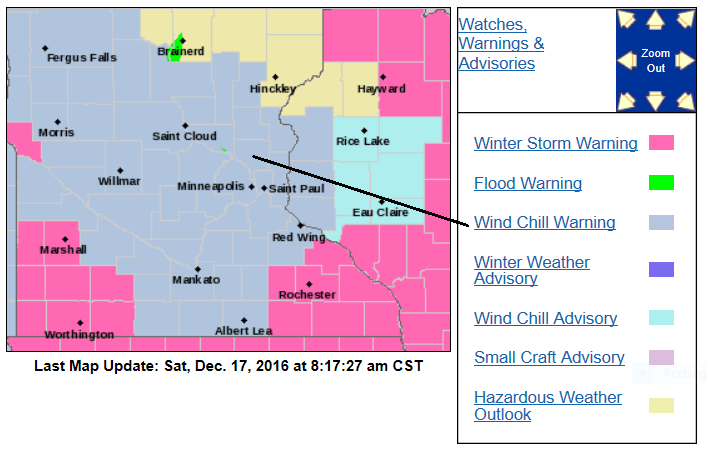
The wind chill warning for western and central Minnesota runs from today through noon on Sunday. For western Wisconsin and eastern Minnesota, including the Twin Cities metro area, the wind chill warning starts at 6 p.m. today and continues until noon on Sunday.
Western and central Minnesota will see wind chill temps in the -25 to -35 range today. Later tonight and Sunday morning, wind chills of -40 to -50 are possible.
Eastern Minnesota and the Twin Cities, plus western Wisconsin will see wind chill temps in the -25 to -40 range tonight and Sunday morning.
Here are some addition details:
URGENT - WINTER WEATHER MESSAGE
NATIONAL WEATHER SERVICE TWIN CITIES/CHANHASSEN MN
803 AM CST SAT DEC 17 2016
...BLOWING SNOW LINGERING...
...BITTERLY COLD WIND CHILLS TONIGHT INTO SUNDAY...
.ACCUMULATING SNOW HAS ENDED...BUT OCCASIONAL BLOWING AND DRIFTING
SNOW WILL CONTINUE THROUGH THE AFTERNOON. SURFACE VISIBILITIES
WILL OCCASIONALLY DROP TO ONE MILE OR LESS IN OPEN COUNTRY DUE TO
THE GUSTY WINDS. THE MAIN WEATHER HAZARD WILL BE STEADY OR FALLING
TEMPERATURES THE REST OF DAY...ALONG WITH WIND CHILL VALUES
DROPPING TO 20 TO 35 DEGREES BELOW ZERO. WIND CHILLS WILL PLUNGE
TO 35 TO 45 BELOW ZERO ACROSS MUCH OF THE AREA THIS EVENING...AND
REMAIN IN THAT RANGE INTO SUNDAY MORNING.
MNZ051-059>063-066>070-074>078-082>085-091>093-WIZ023-024-172215-
/O.CAN.KMPX.WS.W.0006.000000T0000Z-161218T0000Z/
/O.CON.KMPX.WC.W.0002.161218T0000Z-161218T1800Z/
SHERBURNE-WRIGHT-HENNEPIN-ANOKA-RAMSEY-WASHINGTON-MCLEOD-SIBLEY-
CARVER-SCOTT-DAKOTA-BROWN-NICOLLET-LE SUEUR-RICE-GOODHUE-WATONWAN-
BLUE EARTH-WASECA-STEELE-MARTIN-FARIBAULT-FREEBORN-ST. CROIX-
PIERCE-
INCLUDING THE CITIES OF...ELK RIVER...MONTICELLO...MINNEAPOLIS...
BLAINE...ST PAUL...STILLWATER...HUTCHINSON...GAYLORD...CHASKA...
SHAKOPEE...HASTINGS...NEW ULM...ST PETER...LE SUEUR...FARIBAULT...
RED WING...ST JAMES...MANKATO...WASECA...OWATONNA...FAIRMONT...
BLUE EARTH...ALBERT LEA...HUDSON...RIVER FALLS...PRESCOTT
803 AM CST SAT DEC 17 2016
...WIND CHILL WARNING REMAINS IN EFFECT FROM 6 PM THIS EVENING TO
NOON CST SUNDAY...
...WINTER STORM WARNING IS CANCELLED...
THE NATIONAL WEATHER SERVICE IN TWIN CITIES/CHANHASSEN HAS
CANCELLED THE WINTER STORM WARNING.
* EXPECT WIND CHILLS TO RANGE FROM 25 BELOW ZERO TO 45 BELOW ZERO
BETWEEN 6 PM THIS EVENING AND NOON SUNDAY...WITH THE COLDEST
WIND CHILLS OCCURRING AROUND 6 AM SUNDAY.
* THE DANGEROUSLY COLD WIND CHILLS WILL CAUSE FROSTBITE IN AS
LITTLE AS 10 MINUTES TO EXPOSED SKIN.
PRECAUTIONARY/PREPAREDNESS ACTIONS...
A WIND CHILL WARNING MEANS THE COMBINATION OF VERY COLD AIR AND
THE WIND WILL CREATE DANGEROUSLY LOW WIND CHILL VALUES. FROST
BITE CAN OCCUR QUICKLY AND EVEN HYPOTHERMIA OR DEATH IF
PRECAUTIONS ARE NOT TAKEN.
You can see updated winter storm information on our MPR News weather live blog.
Please share your photos and storm reports with our Public Insight Network and we can include them in our coverage.
The Minnesota Department of Transportation has current road conditions.
Cold through Sunday, then milder
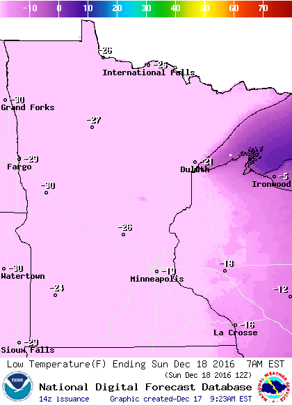
We'll see falling temps today, and lows in the 20s below zero on Sunday morning:
High temperatures will be below zero on Sunday:
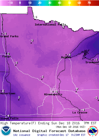
Highs in the teens to around 20 are on tap for Monday, and southern Minnesota and the Twin Cities could hit 30 on Tuesday and Wednesday.
That sounds like grilling weather for some of us!
Programming note
You can hear my live weather updates on Minnesota Public Radio at 7:35 a.m. and 4:35 p.m. each Saturday and Sunday.

