
Sun-splashed 60s
Go Deeper.
Create an account or log in to save stories.
Like this?
Thanks for liking this story! We have added it to a list of your favorite stories.


I heard someone say that it was too "hot" Friday afternoon, when we hit 78 degrees in the Twin Cities.
It was 12 degrees warmer than our average May 5 high temp, but I'll bet that most people enjoyed the warmth!
It was like a taste of June.
Back to the 60s
Turn Up Your Support
MPR News helps you turn down the noise and build shared understanding. Turn up your support for this public resource and keep trusted journalism accessible to all.
Most of Minnesota will be back to the 60s for Saturday high temps.
Some spots in southwestern Minnesota could top 70 degrees, and northeastern Minnesota will see some 50s. Some areas real close to the north shore of Lake Superior might stay in the 40s.
Sunday's highs will be similar to Saturday's:

There's still very little change in our Minnesota high temps on Monday:
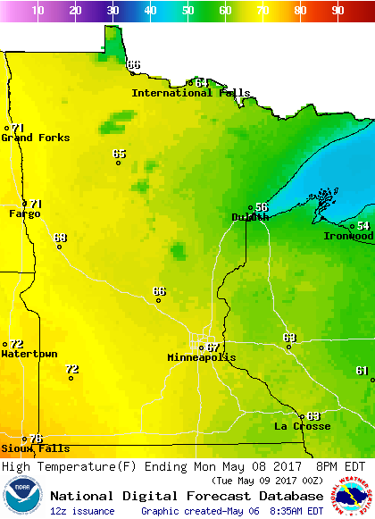
Highs in the upper 60s are expected in the Twin Cities metro area on Tuesday, then mid 60s Wednesday and lower 60s Thursday and Friday.
Rain chances
After a dry weekend, thoughts will turn to our next chance of rain.
The National Oceanic and Atmospheric Administration’s Global Forecast System model shows the potential for showers over southwestern Minnesota Monday afternoon, then the chance of showers spreads to the remainder of Minnesota Monday night and Tuesday:
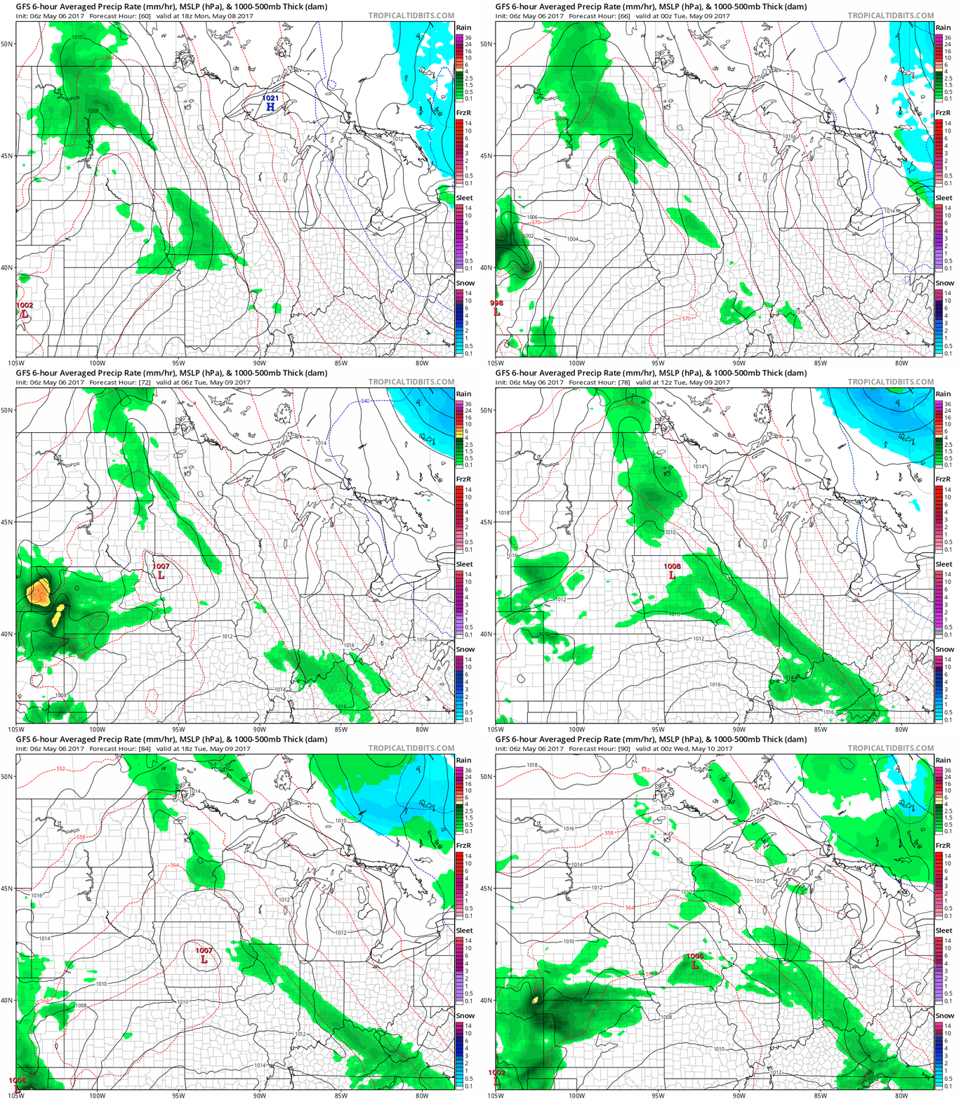
The color chart to the right of the loop refers to the precipitation rate, not the amount of rain.
Tornado anniversary
This Saturday marked the anniversary of the May 6, 1965 tornadoes that hit parts of the Twin Cities metro area:
Here's a summary of the tornadoes of May 6, 1965, from the NWS:
Tornado #1 touched down at 6:08 p.m. CST just east of Cologne ( Carver
County), was on the ground for 13 miles, and dissipated in the northwestern
portion of Minnetrista ( Hennepin County). It was rated an F4, killed three
people and injured 175.
Tornado #2 touched down at 6:27 p.m. CST near Lake Susan in
Chanhassen (Carver County) and traveled 7 miles straight north to
Deephaven (Hennepin County). It was rated an F4, was on the ground for
7 miles, but resulted in no injuries or fatalities.
Tornado #3 touched down at 6:34 p.m. CST about 3 miles east of
New Auburn (Sibley County) and moved to just west of Lester Prairie
(McLeod County). On the ground for 16 miles, it was rated an F3, but
there were no injuries or fatalities.
Tornado #4 touched down at 6:43 p.m. CST about two miles east of
Green Isle (Sibley County), was on the ground 11 miles, and dissipated
about two miles southwest of Waconia (Carver County). It was rated an
F2, killed one person, and injured 175.
Tornado #5 touched down at 7:06 p.m. CST in the southwesternmost
corner of Fridley (Anoka County), moved across the Northern Ordnance
plant, and dissipated just northeast of Laddie Lake in Blaine (Anoka County).
It was on the ground for 7 miles, reached F4 intensity, killed three people and
injured 175.
Tornado #6 touched down at 8:14 p.m. CST in Golden Valley, moved across
north Minneapolis (Hennepin County) and into Fridley (Anoka County), then
Mounds View (Ramsey County), and finally dissipated just west of Centerville
(Anoka County). This was rated an F4, killed six people and injured 158, and
was on the ground for 18 miles.
Minnesota will not see any severe weather this weekend.
April makes 20
The average temperature for April 2017 was 3 degrees warmer than normal at Minneapolis-St. Paul International Airport.
According to the Minnesota State Climatology Office:
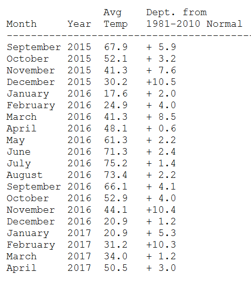
In the Twin Cities, the average monthly temperature has now been above the 1981-2010 normal for 20 months in a row, meaning that MSP airport has not recorded average below-normal monthly temperatures since August 2015. This is also true for St. Cloud. For both stations, this is the longest above-average monthly temperature streak of any kind on record, though it is worth noting that the "normals" refresh every 10 years, and procedures for calculating them have changed over time.
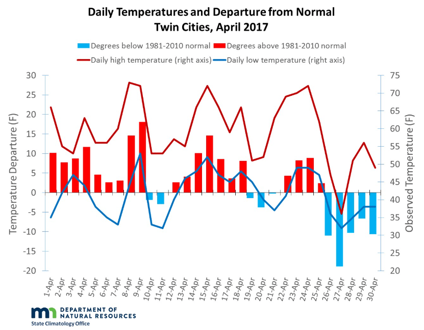
We ended the month with five consecutive cool days, but 20 of the first 25 days in April were warmer than normal:
Here are the average monthly temps and departures from normal for the past 20 months in the Twin Cities, courtesy of the Minnesota State Climatology Office:
Programming note
You can hear my live weather updates on Minnesota Public Radio at 7:49 a.m. Thursdays and Fridays, and at 7:35 and 9:35 a.m., plus 4:35 p.m., each Saturday and Sunday.

