
A warm Sunday; cooler on Monday
Go Deeper.
Create an account or log in to save stories.
Like this?
Thanks for liking this story! We have added it to a list of your favorite stories.


It's been very summery the past few days.
Our average high temp this time of year is 75 degrees in the Twin Cities metro area, but we touched 90 degrees on both Friday and Saturday at Minneapolis-St. Paul International Airport.
Our Sunday will be warm in central and southern Minnesota, with highs in the 80s and a few spots touching 90 degrees.
Northern Minnesota will see highs in the 70s.
Turn Up Your Support
MPR News helps you turn down the noise and build shared understanding. Turn up your support for this public resource and keep trusted journalism accessible to all.
It'll be noticeably less humid today, compared to Saturday.
Cooler on Monday
Monday highs will be mostly in the 70s:

A few spots in southern Minnesota could pop into the lower 80s.
Winds blowing in from Lake Superior will limit high temps to the 60s along the north shore.
Twin Cities high temps are expected to stay in the upper 70s to lower 80s all week.
Rain chance northeast
A low pressure system will move from southern Canada toward Lake Superior on Sunday.
That'll bring scattered showers and possibly a few thunderstorms to northeastern Minnesota and northwestern Wisconsin Sunday afternoon and Sunday evening.
The Storm Prediction Center of the National Weather Service shows the potential for general (non-severe) thunderstorms in northeastern Minnesota and parts of northwestern Wisconsin Sunday and Sunday night:

The remainder of northern Wisconsin could see an isolated severe thunderstorm.
The Storm Prediction Center updates the severe weather outlook several times each day.
Monday and Tuesday look mostly dry in Minnesota, with a chance of showers and isolated thunderstorms returning late Wednesday into Thursday.
Drought relief for Florida?
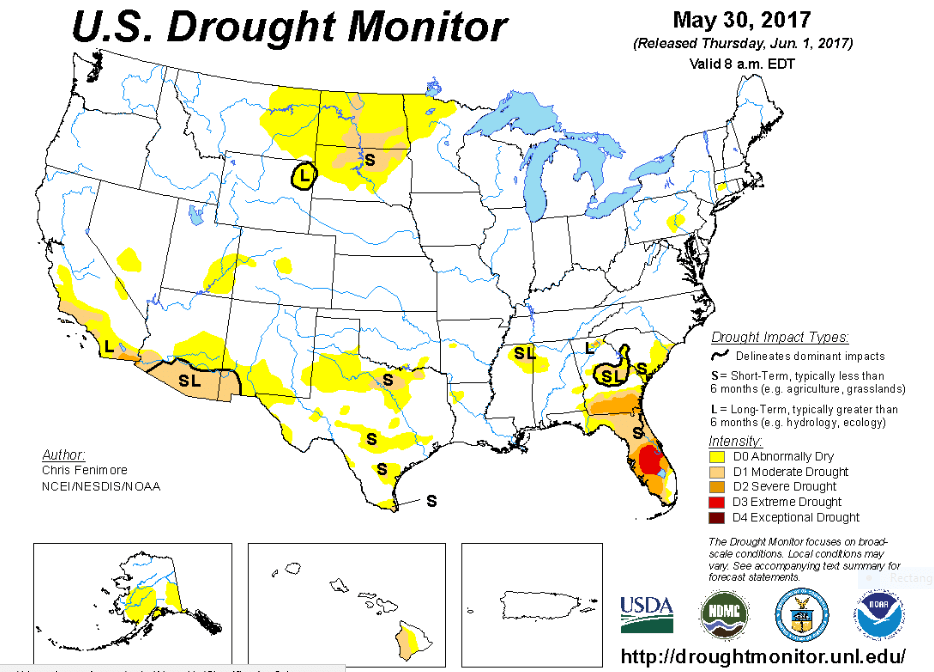
The most recent info from U.S. Drought Monitor shows that Minnesota remains free of drought, although parts of the northwest are abnormally dry:
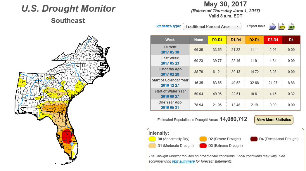
Drought conditions still cover most of Florida, with extreme drought in some areas:
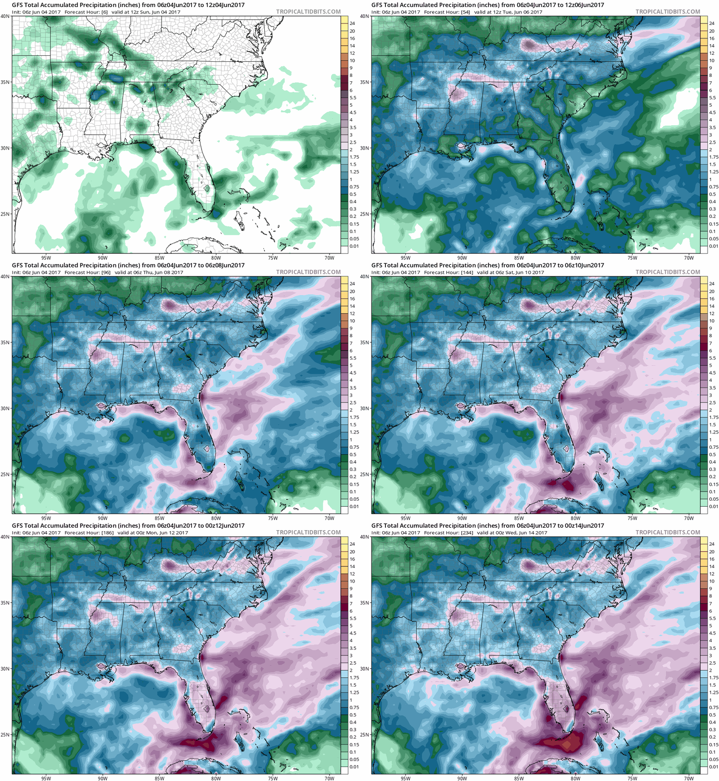
Some periods of helpful rain are expected in Florida over the next 10 days.
The National Oceanic and Atmospheric Administration's Global Forecast System model shows the potential for two to three inches of rain over much of central and south Florida before the middle of June:
Let's hope that they get the rain!
Programming note
You can hear my live weather updates on Minnesota Public radio at 7:49 a.m. Thursdays and Fridays, and at 7:35 a.m. and 9:35 a.m. each Saturday and Sunday.

