
Mix of rain and flakes; several inches of snow for parts of far southern Minnesota
Go Deeper.
Create an account or log in to save stories.
Like this?
Thanks for liking this story! We have added it to a list of your favorite stories.


Computer model trends put the heaviest snow across far southern Minnesota into southern Wisconsin today.
The National Oceanic and Atmospheric Administration’s North American Mesoscale forecast model shows the potential precipitation pattern from Saturday morning through Saturday evening:
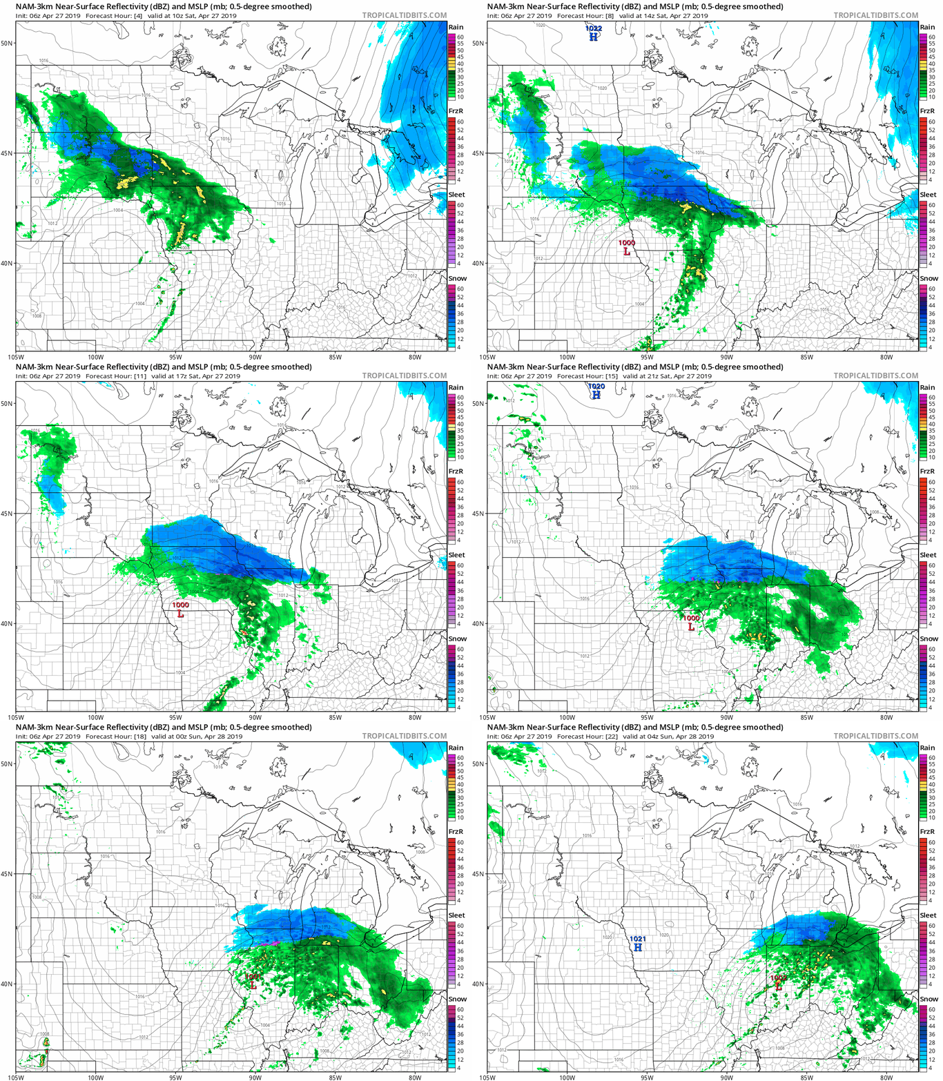
The color chart to the right of the loop refers to the strength of the signal that returns to the radar, not to the amount of snow and rain.
The National Weather Service has issued a winter storm warning for several counties in far south-central Minnesota from 7 a.m. to 3 p.m. today, and for several counties in far southeastern Minnesota from 7 a.m. to 7 p.m. today:
Turn Up Your Support
MPR News helps you turn down the noise and build shared understanding. Turn up your support for this public resource and keep trusted journalism accessible to all.

The remaining counties of southern Minnesota are in a winter weather advisory for lesser snow amounts. The Twin Cities metro area is not included in any warnings or advisories today.
Here are potential snowfall amounts, from the NWS:

Some areas will have thundersnow at times.
The Twin Cities metro area will see a mix of rain and snow today, and I anticipate minor snow accumulation on some grassy areas, mainly in the south metro.
Here are details of the winter storm warning in far southern Minnesota:
URGENT - WINTER WEATHER MESSAGE
National Weather Service Twin Cities/Chanhassen MN
321 AM CDT Sat Apr 27 2019
...HEAVY SNOW EXPECTED ACROSS SOUTHERN MINNESOTA THIS MORNING...
.After initially starting as rain, a period of heavy snow is
expected across southern Minnesota from this morning into early
afternoon. The latest trend has the snow shifting to the south
along I-90 and the Minnesota/Iowa border. Total snowfall in the
warning area will range from 4 to 7 inches, with 1 to 4 inches
expected in the advisory area. Local maximum amounts of 8 inches
are possible. East to northeast winds of 10 to 20 mph with gusts
to 30 mph will accompany the snowfall, which will lead to some
blowing and drifting.
Temperatures will rise above freezing quickly after the snow ends
and travel conditions are expected to improve significantly by
mid afternoon.
MNZ091>093-272000-
/O.EXT.KMPX.WS.W.0010.190427T1200Z-190427T2000Z/
Martin-Faribault-Freeborn-
Including the cities of Fairmont, Blue Earth, and Albert Lea
321 AM CDT Sat Apr 27 2019
...WINTER STORM WARNING NOW IN EFFECT FROM 7 AM THIS MORNING TO
3 PM CDT THIS AFTERNOON...
* WHAT...Heavy snow expected. Total snow accumulations of 4 to 7
inches expected. Winds gusting as high as 35 mph.
* WHERE...Brown, Nicollet and Watonwan Counties.
* WHEN...From 7 AM this morning to 3 PM CDT this afternoon.
* ADDITIONAL DETAILS...Plan on slippery road conditions. Patchy
blowing snow could significantly reduce visibility.
PRECAUTIONARY/PREPAREDNESS ACTIONS...
A Winter Storm Warning for snow means severe winter weather
conditions will make travel hazardous. Conditions will improve
Saturday afternoon.
The latest road conditions for Minnesota can be found at
511mn.org and for Wisconsin at 511wi.gov, or by calling 5 1 1 in
either state.
And for the southeast corner of Minnesota:
URGENT - WINTER WEATHER MESSAGE
National Weather Service La Crosse WI
315 AM CDT Sat Apr 27 2019
...Snowy and Windy with Travel Impacts Expected...
.Snow, heavy at times, will move into the area after daybreak
this morning and then exit the area by evening. 1 to 2 inch per
hour snowfall rates are possible, especially across northeast Iowa
and southwest Wisconsin. Highest totals of 4 of 8 inches are
expected south of Interstate 90.
The bulk of the accumulations will occur on grassy and elevated
surfaces. However, heavier bursts of snow will manage to
accumulate on roadways, leading to slushy accumulations with
impacts to travel.
In addition, wind gusts of 30 to 40 mph combined with the wet
snow will likely lead to some tree damage and perhaps isolated
power outages.
The location of the heaviest snow band may still change a bit.
Monitor the latest weather information closely.
IAZ008>011-018-019-029-030-MNZ094>096-WIZ053>055-061-271615-
/O.CON.KARX.WS.W.0011.190427T1200Z-190428T0000Z/
Mitchell-Howard-Winneshiek-Allamakee-Floyd-Chickasaw-Fayette-
Clayton-Mower-Fillmore-Houston-Vernon-Crawford-Richland-Grant-
Including the cities of Osage, Cresco, Decorah, Waukon,
Charles City, New Hampton, Oelwein, Elkader, Austin, Preston,
Caledonia, Viroqua, Prairie Du Chien, Richland Center,
and Platteville
315 AM CDT Sat Apr 27 2019
...WINTER STORM WARNING REMAINS IN EFFECT FROM 7 AM THIS MORNING
TO 7 PM CDT THIS EVENING...
* WHAT...Heavy snow...accumulations of 4 to 8 inches expected.
Winds gusting as high as 35 mph.
* WHERE...Portions of southwest Wisconsin, north central and
northeast Iowa and southeast Minnesota.
* WHEN...From 7 AM to 7 PM CDT Saturday.
* ADDITIONAL DETAILS...Travel could be very difficult.
PRECAUTIONARY/PREPAREDNESS ACTIONS...
A Winter Storm Warning for snow means severe winter weather
conditions will make travel very hazardous or impossible. If you
must travel, keep an extra flashlight, food and water in your
vehicle in case of an emergency.
The latest road conditions for Iowa can be found on-line at
511ia.org, in Minnesota at 511mn.org, and in Wisconsin at
511wi.gov or by calling 5 1 1.
You can check the latest forecasts from the weather service offices in the Twin Cities, Sioux Falls, S.D. and La Crosse, Wis.
As always, updated weather information can be heard on the Minnesota Public Radio Network, and you’ll also see updated weather info on the MPR News live weather blog.
This blog will be updated around 9:30 a.m.
Programming note
You can hear my live weather updates on Minnesota Public Radio at 7:49 a.m. Thursdays and Fridays, and at 7:35 a.m., 9:35 a.m. and 4:35 p.m. each Saturday and Sunday.

