
Rain southern and central Minn. Sunday night and early Monday, snow to the north
Go Deeper.
Create an account or log in to save stories.
Like this?
Thanks for liking this story! We have added it to a list of your favorite stories.


Our average high temperature is 64 in the Twin Cities metro area this time of year, but it can be quite a bit cooler or warmer than that on any given late-April day.
Our highs were drastically cooler this weekend than they were last weekend. The temp at Minneapolis-St. Paul International Airport topped out at 51 this Saturday and 54 on Sunday. Just one week ago, we had a high of 78 on Saturday (April 20) and 77 on Sunday (April 21).
I guess it's appropriate that the average metro area high of the past two weekends combined would be in the 60s.
Temperature trends
Turn Up Your Support
MPR News helps you turn down the noise and build shared understanding. Turn up your support for this public resource and keep trusted journalism accessible to all.
Monday highs will be mainly in the 40s over northern Minnesota, with some 50s in the south:

They could see some highs in the 30s near Lake Superior.
Twin Cities metro highs are projected to be around 50 on Tuesday, followed by lower 50s Wednesday, upper 50s Thursday and around 60 on Friday.
Rain and snow
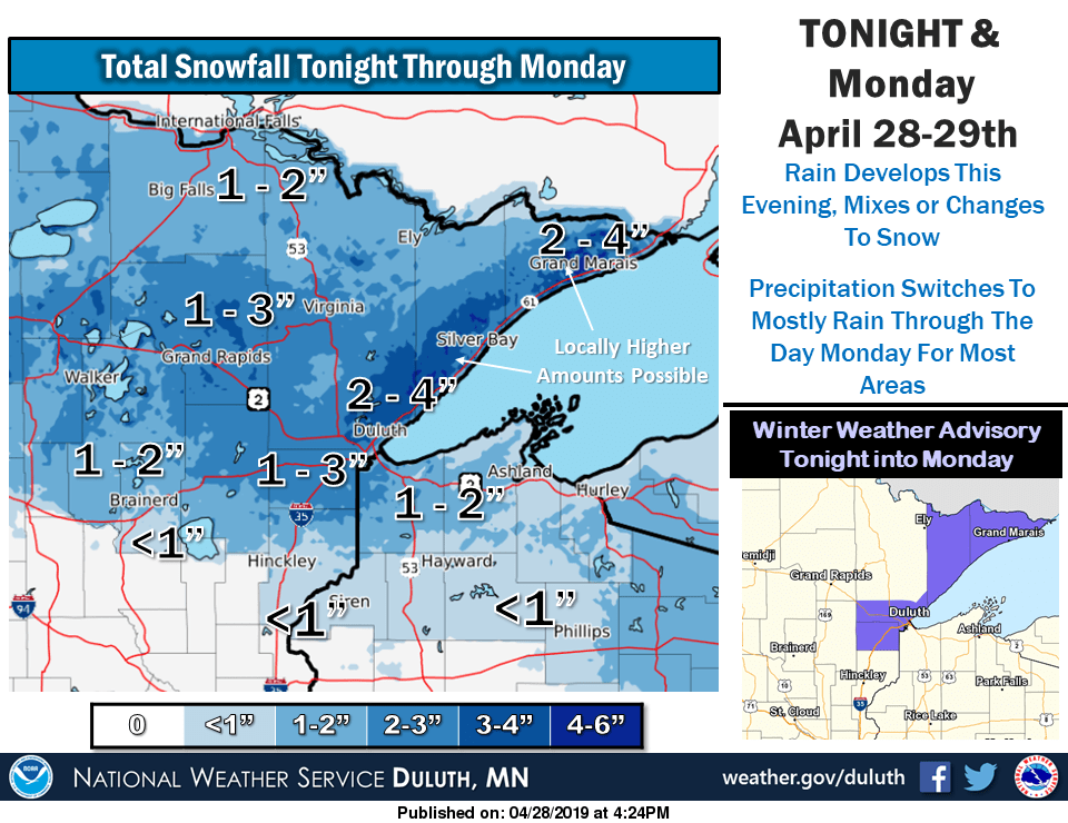
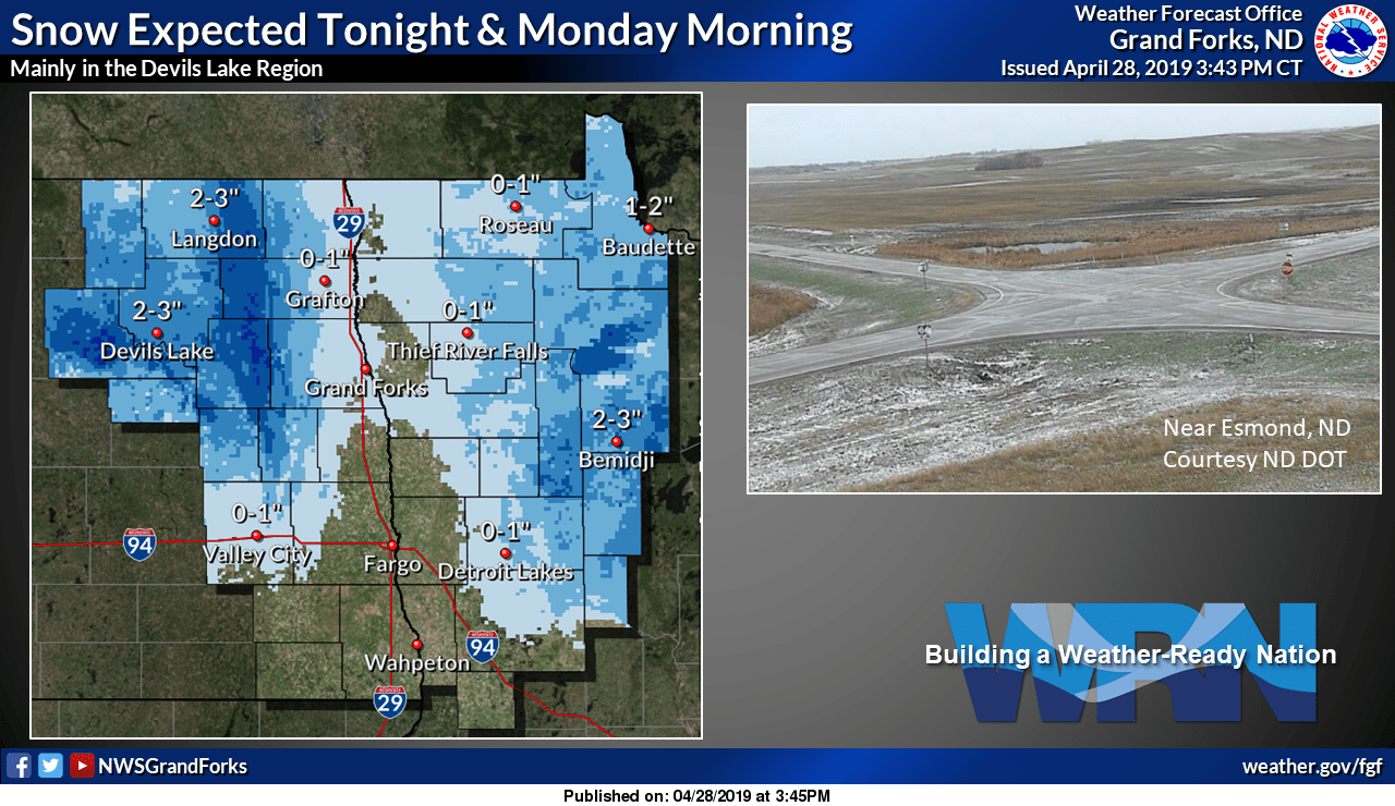
Roughly the northern third of Minnesota, plus northwestern Wisconsin, will see a rain/snow mix change to mostly snow overnight Sunday night and continue into Monday morning. Precipitation could linger in parts of northeastern Minnesota into Monday afternoon as a rain/snow mix.
Central and southern Minnesota, plus west-central Wisconsin, will see periods of rain overnight Sunday night, which tapers off from west to east Monday morning. I wouldn't be surprised to see a few wet snowflakes over central Minnesota as well.
The National Oceanic and Atmospheric Administration’s North American Mesoscale forecast model shows the potential precipitation pattern from Sunday evening through Monday evening:
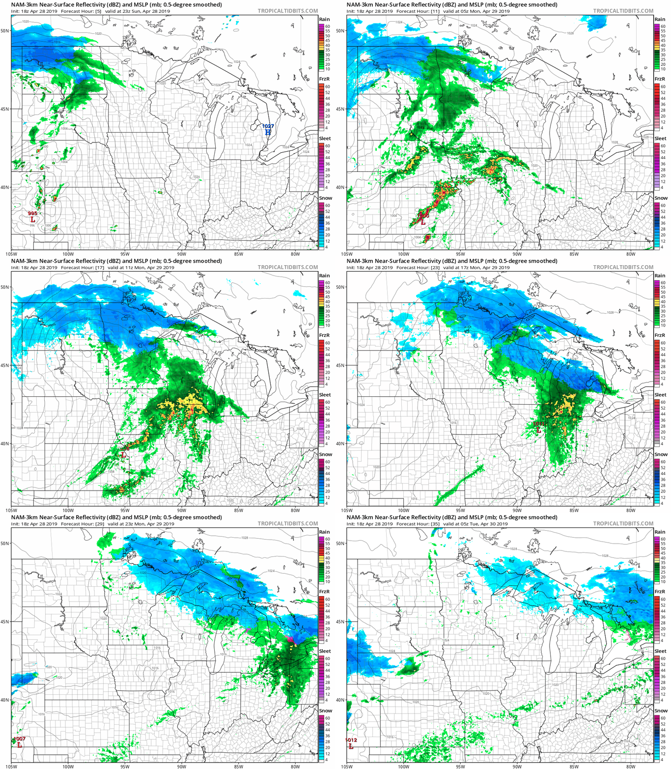
The color chart to the right of the loop refers to the strength of the signal that returns to the radar, not to the amount of rain or snow.
Here are NWS snow forecasts for northeastern and north-central Minnesota, with "tonight" referring to the overnight hours of Sunday night:
And the NWS forecast snow amounts for northwestern Minnesota:
You can check for forecast updates from the National Weather Service offices in the Twin Cities, Grand Forks, N.D. and Duluth.
As always, updated weather information can be heard on the Minnesota Public Radio Network, and you’ll also see updated weather info on the MPR News live weather blog.
River levels
There are numerous flood warnings still in effect along rivers in Minnesota. You can get flood warning updates by clicking on any green-shaded location on the National Weather Service Twin Cities website. The latest flood warnings for northwestern Minnesota can be found on the NWS Grand Forks, N.D. site.
You can click on any location on the NWS Advanced Hydrologic Prediction Service (AHPS) site to get hydrographs of recent and forecast river levels. Some locations list levels in feet above sea level, others list levels in feet above a local reference point.
Here’s the Sunday evening hydrograph for the Mississippi River at St. Paul:

The river level at St. Paul continues to trend downward, but portions of Harriet Island Regional Park in St. Paul were still flooded as of Sunday evening:

Projected river levels are updated on a regular basis, so check back to the AHPS site and the NWS point forecasts for the latest info on the rivers near you.
If you’d like to scroll through hydrographs along a certain river in central or southern Minnesota, check here. Hydrographs for the Red River can be found here.
I hope that you have a good week!

