A summery stretch, then cooler on Sunday; Minnesota crop update
Our average high temperature is 76 degrees this time of year in the Twin Cities metro area. We'll be well into the 80s the next few days. Our Twin Cities average high temperature peaks at 84 degrees, from July 6 through July 21.
So, you might say that this current stretch of warm weather is our July preview.
Temperature trends
Thursday afternoon highs will be in the 80s across most of Minnesota plus western Wisconsin. There'll be some 70s in north-central and northeastern Minnesota and even a few 60s around Grand Marais.
Create a More Connected Minnesota
MPR News is your trusted resource for the news you need. With your support, MPR News brings accessible, courageous journalism and authentic conversation to everyone - free of paywalls and barriers. Your gift makes a difference.
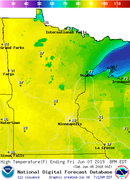
Similar highs are on tap for Friday:

Saturday will also feature a lot of highs in the 80s, with highs retreating into the lower 80s in the northwest:

Western and northern Minnesota only reach the 60s on Sunday, with 70s elsewhere:

Twin Cities metro area highs are projected to reach the mid 70s next Monday and Tuesday, followed by lower 70s next Wednesday.
Rain chances
Central and northeastern Minnesota could see some scattered showers and an isolated thunderstorm Thursday afternoon and evening. The Twin Cities metro area is expected to stay dry.
As always, updated weather information can be heard on the Minnesota Public Radio Network, and you’ll also see updated weather info on the MPR News live weather blog.
Friday looks dry. Some showers and embedded t-storms are possible in western Minnesota Saturday, then eastern Minnesota and western Wisconsin could see a few scattered showers/t-storms Saturday night into Sunday morning.
The National Oceanic and Atmospheric Administration’s Global Forecast System model shows the potential rain pattern Saturday through Sunday:

The color chart to the right of the loop refers to the precipitation rate (mm per hour), not to the total amount of rain.
Crop update
Our cool and wet spring has delayed crop planting in many parts of Minnesota. Monday’s Minnesota Crop Progress & Condition report from the USDA and the Minnesota Department of Agriculture states:
Minnesota farmers had 3.4 days suitable for fieldwork during the week ending June 2, 2019, according to USDA’s National Agricultural Statistics Service. Planting progress was made for all crops in Minnesota given slightly drier conditions. Warmer temperatures also aided crop emergence and development in the state this week.
Topsoil moisture supplies were rated 0 percent very short, 3 percent short, 55 percent adequate and 42 percent surplus. Subsoil moisture supplies were rated 0 percent very short, 3 percent short, 53 percent adequate and 44 percent surplus.
Seventy-six percent of Minnesota’s corn was planted, 13 days behind last year and 17 days behind the five-year average. Forty-eight percent of the corn crop had emerged, nearly 2 weeks behind normal. Soybeans were 51 percent planted, 12 days behind last year and 16 days behind the average, while 16 percent of the soybean crop had emerged.
Over the past five years in Minnesota, an average of 98% of our corn and 90% of our soybeans have been planted by June 2:

Programming note
You can hear my live weather updates on Minnesota Public Radio at 7:49 a.m. Thursdays and Fridays, and at 7:35 a.m., 9:35 a.m. and 4:35 p.m. each Saturday and Sunday.