
Update on our steamy weekend; A Sunday rain chance
Go Deeper.
Create an account or log in to save stories.
Like this?
Thanks for liking this story! We have added it to a list of your favorite stories.


This will be our first steamy weekend of 2019.
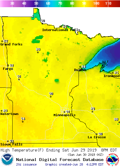
Saturday highs will hit 90 degrees or warmer across much of Minnesota and parts of western Wisconsin:
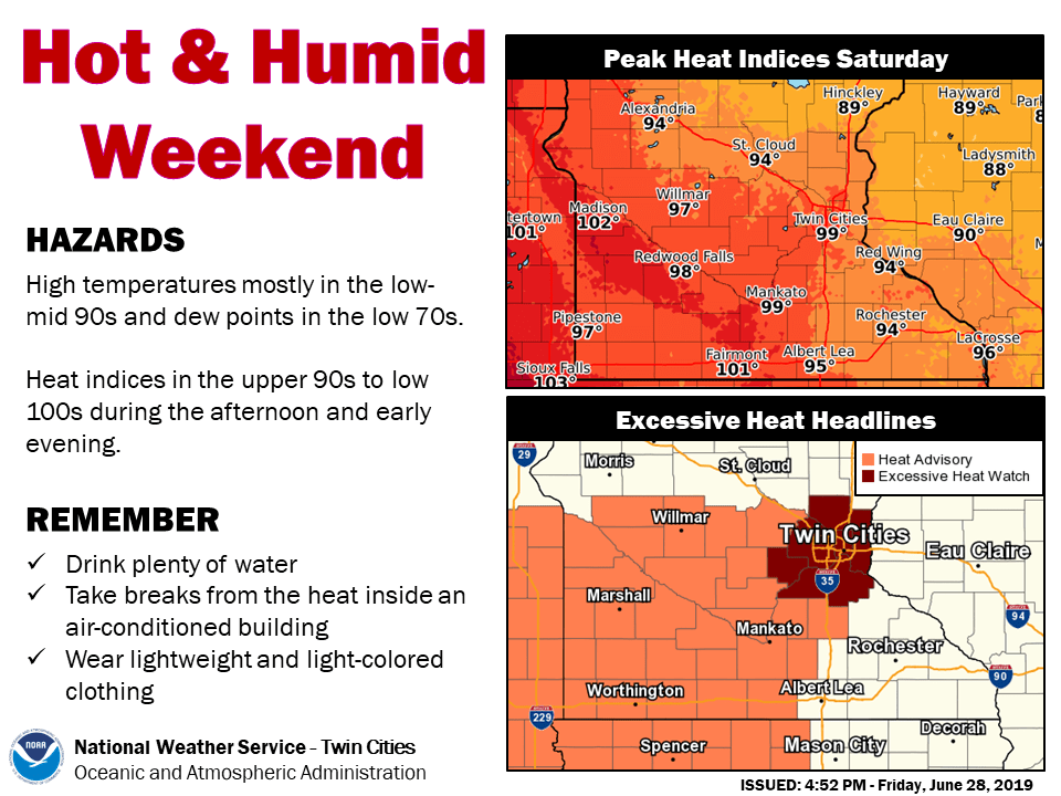
Dew point temperatures will reach the steamy 70s in the many areas, which will raise our afternoon heat index values toward 100 degrees.
Sunday highs are expected to be in 90s in about the southern half of Minnesota, plus western Wisconsin:
Turn Up Your Support
MPR News helps you turn down the noise and build shared understanding. Turn up your support for this public resource and keep trusted journalism accessible to all.

The weekend heat and humidity has prompted the National Weather Service to issue an excessive heat watch for the Twin Cities metro area from Saturday morning through Sunday evening, plus a Saturday heat advisory that covers areas to the west and southwest:
Details of the excessive heat watch:
URGENT - WEATHER MESSAGE
National Weather Service Twin Cities/Chanhassen MN
244 PM CDT Fri Jun 28 2019
MNZ060>063-068>070-290430-
/O.CON.KMPX.EH.A.0001.190629T1400Z-190701T0300Z/
Hennepin-Anoka-Ramsey-Washington-Carver-Scott-Dakota-
Including the cities of Minneapolis, Blaine, St Paul, Stillwater,
Chaska, Shakopee, and Hastings
244 PM CDT Fri Jun 28 2019
...EXCESSIVE HEAT WATCH REMAINS IN EFFECT FROM SATURDAY MORNING
THROUGH SUNDAY EVENING...
* TEMPERATURE...Afternoon heat indices Saturday and Sunday
afternoon are expected to top out around 100 degrees, with
overnight lows Sunday morning only falling to around 75
degrees.
* IMPACTS...These warm temperatures during the day, with limited
cooling overnight Saturday night will lead to increased risk
for heat related illnesses for those active outdoors or with
limited access to air conditioned spaces.
PRECAUTIONARY/PREPAREDNESS ACTIONS...
An Excessive Heat Watch means that a prolonged period of hot
temperatures is expected. The combination of hot temperatures and
high humidity will combine to create a dangerous situation in
which heat illnesses are possible. Drink plenty of fluids...stay
in an air-conditioned room...stay out of the sun...and check up
on relatives and neighbors.
You can check here for updates on heat-related advisories.
Heat safety
The weekend combination of heat and humidity could cause health and safety issues for some people.
Here are some heat safety tips from NOAA:
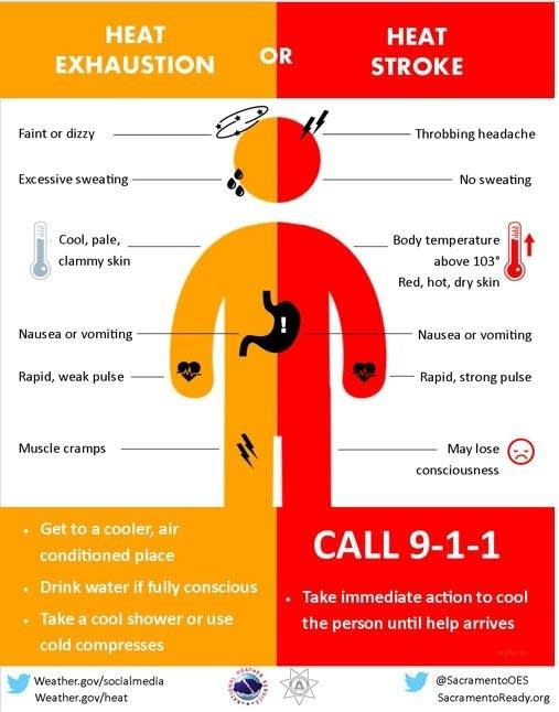
Here are the symptoms of heat exhaustion and heat stroke:
Rain chances
Northwestern Minnesota could see some showers and t-storms Saturday afternoon and early Saturday evening. That shower/t-storm chance would tend to spread to the south and east overnight Saturday night. Minnesota and western Wisconsin will have a chance of scattered showers/t-storms Sunday and Sunday evening.
NOAA’s North American Mesoscale forecast model shows the potential rain pattern Saturday afternoon through Sunday evening:
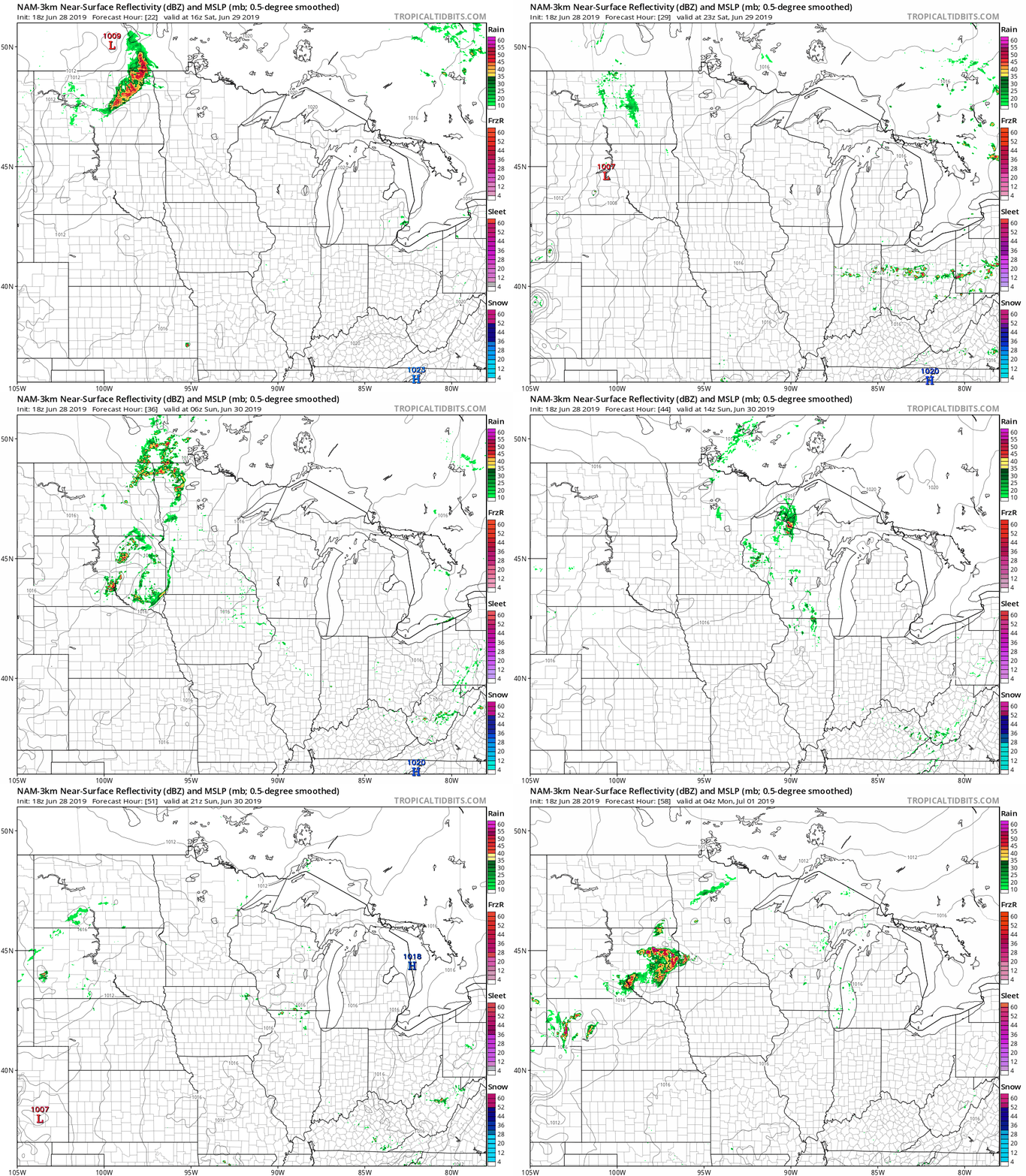
The color chart to the right of the loop refers to the strength of the signal that returns to the radar, not to the amount of rain. It’ll rain in some areas that look dry in the NAM loop, but the loop shows the general rain pattern within the model.
As always, updated weather information can be heard on the Minnesota Public Radio Network, and you’ll also see updated weather info on the MPR News live weather blog.
Southeastern Minnesota flooding
Some roads in Dodge county and western Olmsted county were still closed Friday evening due to the torrential rains that fell Thursday night in parts of southeastern Minnesota:
Portions of southeastern Minnesota had rain totals of 4 to 7 inches Thursday night into early Friday. The Minnesota State Climatology Office has compiled a summary of the epic rains. The NWS summary and rainfall totals can be found here.
Rochester set a new June single-day rainfall record on Friday:
Standard time is used for climate records, so June 28 began at 1 a.m. CDT. Rochester reported .73 of an inch of rain Thursday, giving them a two day total of 5.63 inches. This is now the fourth-wettest June in Rochester weather records:
And this is the second-wettest January through June, which includes the water content of snowfalls.
Unfortunately, it looks like southern Minnesota could see several episodes of thunderstorms this coming week, with the potential for heavy rain at times.

