
Showers and storms at times this week; Friday high of 114.6 degrees was new French record
Go Deeper.
Create an account or log in to save stories.
Like this?
Thanks for liking this story! We have added it to a list of your favorite stories.


We're in a weather pattern that won't allow us to forecast a single rain-free day this week. We will have off and on showers and thunderstorms this week in much of central and southern Minnesota, parts of northern Minnesota and western Wisconsin.
We had two rounds of thunderstorms in the Twin Cities on Sunday, which kept our temperatures in check. This satellite loop shows the clouds as thunderstorms erupted over southeastern Minnesota and parts of South Dakota during the afternoon hours:
You can almost feel the energy as the thunderstorms blossomed.
Thunderstorm chances
Turn Up Your Support
MPR News helps you turn down the noise and build shared understanding. Turn up your support for this public resource and keep trusted journalism accessible to all.
Thunderstorm chances increase across much of central and southern Minnesota overnight Sunday night, and spread into western Wisconsin. Northern Minnesota could see some scattered showers and an isolated thunderstorm.
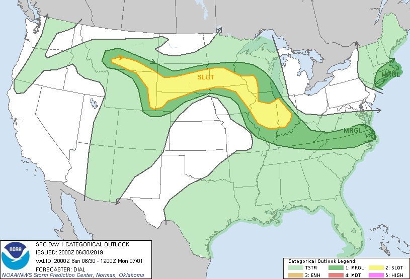
The Storm Prediction Center of the National Weather Service shows a slight risk of severe weather overnight Sunday night (the outlook below runs through 7 a.m. Monday) in portions of southern Minnesota and southwestern Wisconsin:
As always, updated weather information can be heard on the Minnesota Public Radio Network, and you’ll also see updated weather info on the MPR News live weather blog.
You can see the recent local NWS radar loop here. The recent radar loop for southwestern Minnesota can be found here, and the southeastern Minnesota loop here. The northeastern Minnesota radar loop and the northwestern Minnesota radar loop are also available.
Periods of showers and thunderstorms are likely Monday and Monday night in central and southern Minnesota, with a smaller chance to the north. Some localized heavy rain will be possible. As mentioned at the top, off and on showers and thunderstorms are in the forecast each day this week.
Temperature trends
Highs should reach the 80s in much of Minnesota and western Monday afternoon, with a few upper 70s:
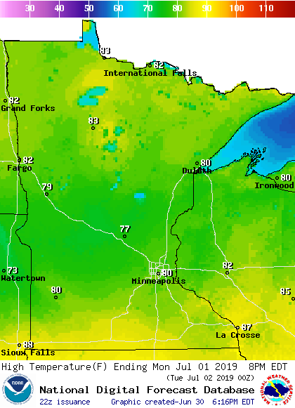
Our average high temp is 83 degrees this time of year in the Twin Cities metro area. Twin Cities highs are projected to reach the mid 80s Tuesday and Wednesday, followed by lower 80s Thursday and Friday.
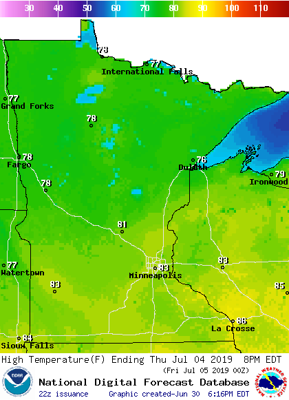
Thursday is the Fourth of July, so it makes sense to look at projected highs across Minnesota and western Wisconsin:
New French heat record
According to the Washington Post, a new French high temperature record was set on Friday:
For a third straight day, a ferocious heat wave is baking large parts of Europe, and the exceptionally high temperatures are making history. On Friday, the town of Gallargues-le-Montueux in southern France hit 114.6 degrees (45.9 Celsius), the hottest temperature ever recorded in the country.
The scorching temperature easily surpassed, by more than 3 degrees, the previous record of 111.4 degrees (44.1 Celsius) set in the southern town of Conqueyrac in France’s historic 2003 heat wave, which was blamed for 15,000 deaths.
The Friday article also noted:
Historic heat has scorched western and central Europe since Wednesday, when national June temperature records fell in Germany, Luxembourg, Andorra, Poland and the Czech Republic.

