
Fourth of July warmth and thunder chances; 20th anniversary of BWCA blowdown
Go Deeper.
Create an account or log in to save stories.
Like this?
Thanks for liking this story! We have added it to a list of your favorite stories.


Happy Fourth of July!
It'll feel very summery today across most of Minnesota and western Wisconsin, with areas of showers and thunderstorms at times.
Temperature trends
Our Thursday high temps will reach the 80s across most of Minnesota and western Wisconsin, with some 70s in parts of north-central and northeastern Minnesota. Metro area highs are expected to reach the mid-to-upper 80s. Our average high temp is 83 degrees this time of year in the Twin Cities metro area, but we've seen a wide range of July 4 high temps over the years. The hottest Twin Cities high on July 4 was 101, in 2012. Our coldest July 4 high temp in the Twin Cities was 58 degrees, in 1967.
Turn Up Your Support
MPR News helps you turn down the noise and build shared understanding. Turn up your support for this public resource and keep trusted journalism accessible to all.
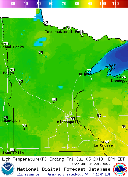
Friday highs are expected to be in the 70s northwest, with 80s southeast:
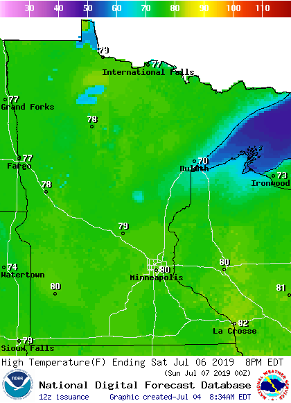
Saturday highs will be mainly in the 70s to around 80, but cooler near Lake Superior:
Highs won't change much on Sunday:
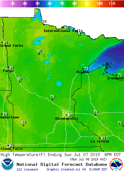
Twin Cities metro area highs are projected to be in the lower 80s Monday through Wednesday of next week.
Rain and thunder chances
The atmosphere over Minnesota and western Wisconsin will remain unsettled today through Friday, with scattered showers and thunderstorms at times. Outflow from one batch of t-storms can ignite another batch of t-storms as it moves through the humid air.
The Storm Prediction Center of the National Weather Service shows a marginal risk of severe weather this Thursday and Thursday night for portions of Minnesota and Wisconsin:
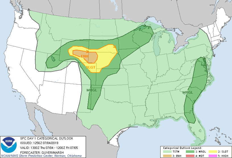
Marginal risk means that an isolated severe thunderstorm is possible.
_______________________________________________________________________
2 p.m. Update
The NWS has issued a flash flood watch valid until 7 p.m. this Thursday from Pine county up through southern St. Louis county and also for portions of northwestern Wisconsin:

There is also a flash flood warning until 5 p.m. for portions of Bayfield and Ashland counties of Wisconsin.
Details of the flash flood watch:
National Weather Service Duluth MN
131 PM CDT Thu Jul 4 2019
MNZ037-038-WIZ001>003-006>008-050000-
/O.NEW.KDLH.FF.A.0002.190704T1831Z-190705T0000Z/
/00000.0.ER.000000T0000Z.000000T0000Z.000000T0000Z.OO/
Carlton and South St. Louis-Pine-Douglas-Bayfield-Ashland-Burnett-
Washburn-Sawyer-
Including the cities of Duluth, Pine City, Hinckley, Superior,
Washburn, Bayfield, Ashland, Grantsburg, Spooner, and Hayward
131 PM CDT Thu Jul 4 2019
...FLASH FLOOD WATCH IN EFFECT UNTIL 7 PM CDT THIS EVENING...
The National Weather Service in Duluth has issued a
* Flash Flood Watch for portions of Minnesota and northwest
Wisconsin, including the following areas, in Minnesota,
Carlton and South St. Louis and Pine. In northwest Wisconsin,
Ashland, Bayfield, Burnett, Douglas, Sawyer, and Washburn.
* Until 7 PM CDT this evening
* Storms are producing heavy rainfall rates across the watched
area and will continue to do so through this evening. If storms
repeatedly cross the same area, flash flooding is possible.
PRECAUTIONARY/PREPAREDNESS ACTIONS...
A Flash Flood Watch means that conditions may develop that lead
to flash flooding. Flash flooding is a very dangerous situation.
You should monitor later forecasts and be prepared to take action
should Flash Flood Warnings be issued.
For the latest flash flood watch and warning info, check the NWS Duluth site.
_________________________________________________________________
Will it rain on our fireworks this Thursday evening? Perhaps, but most locations should be dry during the fireworks. The areas of showers and thunderstorms that develop today should become much more scattered by sunset. Here's what NOAA's High Resolution Rapid Refresh (HRRR) model shows for our Thursday evening rain pattern:
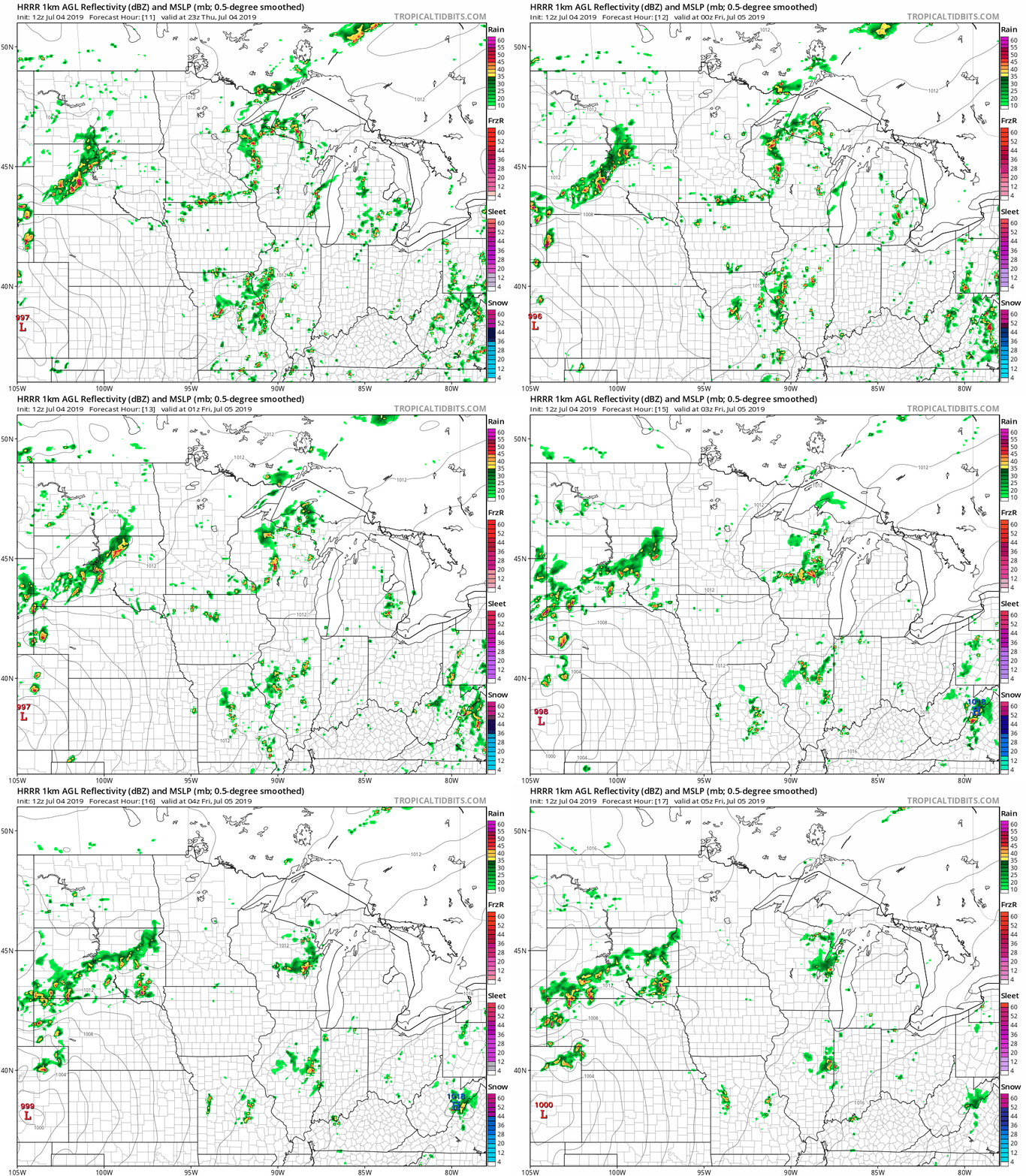
The color chart to the right of the loop refers to the strength of the signal that returns to the radar, not to the amount of rain. It will rain in some areas that look dry in the HRRR loop, but the loop shows the decreasing evening rain coverage within the model. Check forecast updates.
As always, updated weather information can be heard on the Minnesota Public Radio Network, and you’ll also see updated weather info on the MPR News live weather blog.
You can see the recent local NWS radar loop here. The recent radar loop for southwestern Minnesota can be found here, and the southeastern Minnesota loop here. The northeastern Minnesota radar loop and the northwestern Minnesota radar loop are also available.
20th anniversary of BWCA blowdown
An epic derecho raced across northern Minnesota 20 years ago today:
According to the NWS summary:
In the blowdown event, nearly 500,000 acres of the Superior National Forest were almost completely flattened by intense thunderstorm winds estimated to have been between 80 and 100 mph, and hundreds of campers and paddlers that were in the Boundary Waters for the Independence Day Holiday Weekend were stranded in a maze of fallen trees and debris - many of them injured and in desperate need of assistance, only to be faced with the fact that all the ways in and out of the Boundary Waters were blocked by miles of fallen large trees.
Here is an MPR News post from the 10th anniversary of the storms, in 2009. A meteorological study of the Boundary Waters Blowdown can be found here.

