
Friday shower/t-storm chance; less humid this weekend
Go Deeper.
Create an account or log in to save stories.
Like this?
Thanks for liking this story! We have added it to a list of your favorite stories.


Many of us had just a few minutes of rain on the Fourth of July, and some people saw no rain at all. Several locations in Minnesota and northwestern Wisconsin had more persistent rains, and some spots had flooding.
This was the scene in Sartell, Minn., near St. Cloud, after they received several inches of rain on Thursday:
Sections of northwestern Wisconsin also saw heavy rain on Independence Day, and there were flash flood watches and warnings for several counties in northwestern Wisconsin Thursday afternoon and early Thursday evening. You can check the NWS Duluth site for the latest radar images and any flooding updates.
Anchorage heat
Turn Up Your Support
MPR News helps you turn down the noise and build shared understanding. Turn up your support for this public resource and keep trusted journalism accessible to all.
Thursday was a record-tying hot day in Anchorage, Alaska:
Their temp could go slightly higher before the day is done. Our high temperature at Minneapolis-St. Paul International Airport was 85 degrees this Fourth of July.
Friday thunderstorm chances
A batch of showers and thunderstorms is expected to reach parts of southwestern and west-central Minnesota Friday morning, then break up into scattered showers and thunderstorms as it moves eastward during the day.
The National Oceanic and Atmospheric Administration's North American Mesoscale forecast model shows the potential rain pattern Friday morning through Friday evening:
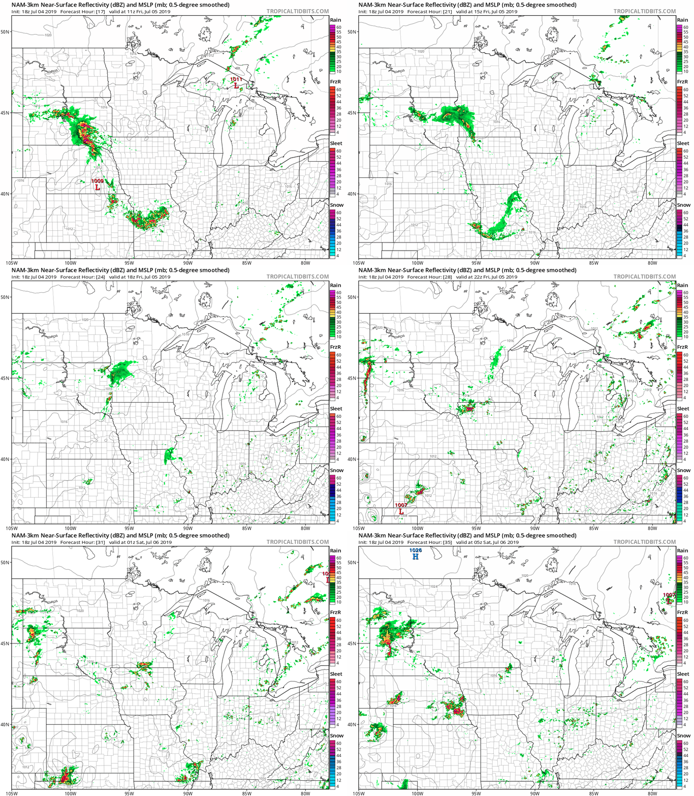
The color chart to the right of the loop refers to the strength of the signal that returns to the radar, not to the amount of rain. It will rain in some areas that look dry in the NAM, but the loop shows the decreasing coverage as the rain moves eastward on Friday. Check forecast updates.
As always, updated weather information can be heard on the Minnesota Public Radio Network, and you’ll also see updated weather info on the MPR News live weather blog.
You can see the recent local NWS radar loop here. The recent radar loop for southwestern Minnesota can be found here, and the southeastern Minnesota loop here. The northeastern Minnesota radar loop and the northwestern Minnesota radar loop are also available.
The Storm Prediction Center of the National Weather Service shows a marginal risk of severe weather for portions of southern Minnesota and southwestern Wisconsin Friday and Friday night:
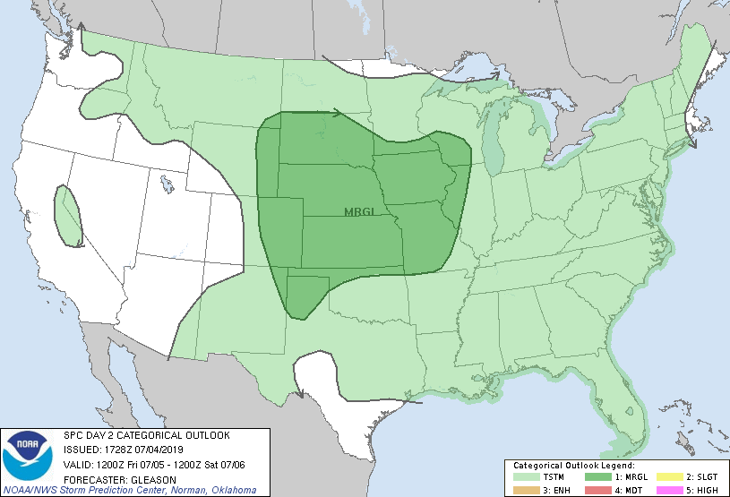
Marginal risk means that an isolated severe thunderstorm is possible.
Temperature trends
Friday highs will be mainly in the upper 70s to lower 80s:
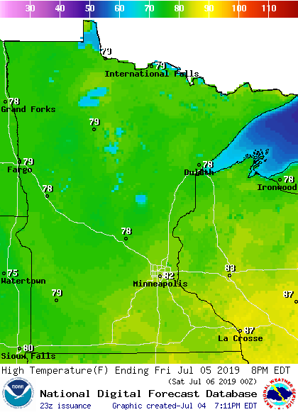
hig
Saturday highs will be slightly cooler in some areas:
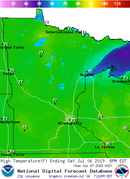
Similar highs are on tap for Sunday:
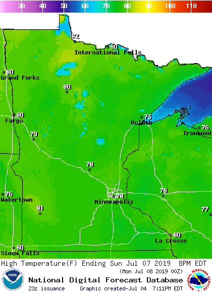
Some spots in the Twin Cities metro area are expected to hit 80 on Saturday and Sunday. Metro area highs are projected to be in the lower 80s Monday through Wednesday of next week.
I hope that you're enjoying this Fourth of July holiday weekend!

