
Friday evening showers and thunderstorms; a quiet weekend
Go Deeper.
Create an account or log in to save stories.
Like this?
Thanks for liking this story! We have added it to a list of your favorite stories.


Areas of rain with embedded thunderstorms will move across central and southern Minnesota and western Wisconsin as we go through Friday evening. A severe thunderstorm will be possible, and some areas could see heavy rain.
_________________________________________________________________________
Evening update
There were reports of tornado touchdowns near Arlington and Henderson in Sibley county between 5:25 and 5:45 p.m. on Friday. Here are the reports via the Twin Cities office of the National Weather Service:
Turn Up Your Support
MPR News helps you turn down the noise and build shared understanding. Turn up your support for this public resource and keep trusted journalism accessible to all.


_____________________________________________________________________
Severe weather outlook
The Storm Prediction Center of the National Weather Service shows a marginal risk of severe weather for portions of southern Minnesota and southwestern Wisconsin this Friday and Friday night:
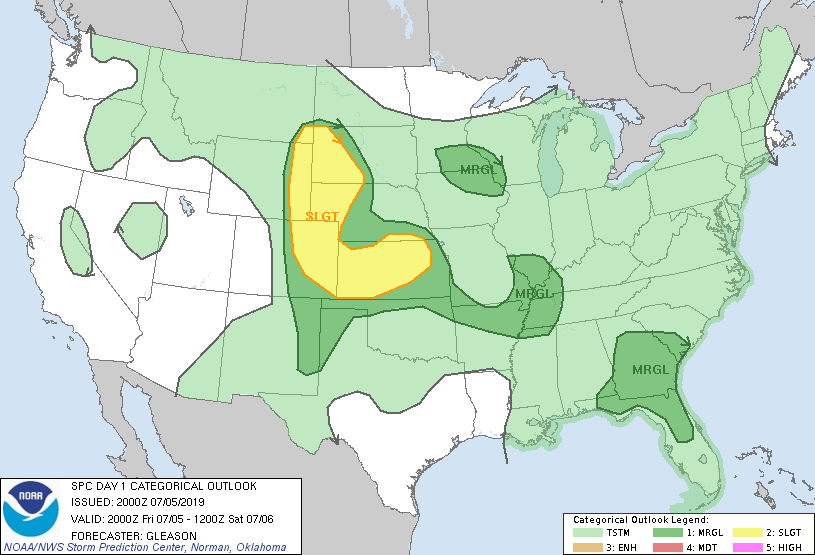
Marginal risk means that an isolated severe thunderstorm is possible. Roughly the southern half of the Twin Cities metro area, plus Pierce county of west-central Wisconsin, are included in the SPC marginal risk area.
As always, updated weather information can be heard on the Minnesota Public Radio Network, and you’ll also see updated weather info on the MPR News live weather blog.
You can see the recent local NWS radar loop here. The recent radar loop for southwestern Minnesota can be found here, and the southeastern Minnesota loop here. The northeastern Minnesota radar loop and the northwestern Minnesota radar loop are also available.
Be sky-aware this Friday evening.
Saturday and Sunday should be rain-free across most of Minnesota and western Wisconsin. Southern Minnesota and the Twin Cities metro area could see an isolated afternoon shower or thunderstorm.
Temperature trends
Most of Minnesota and western Wisconsin will have highs in the upper 70s to the lower 80s this weekend, but it’ll be cooler near Lake Superior.
Here are the Saturday highs:
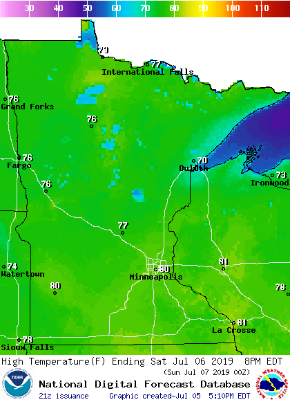
Sunday's projected highs are similar:

I think that some spots in the Twin Cities metro area will touch 80 degrees on Sunday.
Twin Cities metro area highs are projected to be in the lower 80s Monday through Thursday of next week. I'm not seeing any really hot temperatures in the forecast models, but the European forecast model does give us a shot at 90 degrees in the Twin Cities on July 13.
EF-0 tornado in Rusk county, Wisconsin on Thursday
The NWS confirmed that a weak tornado touched down on the Fourth of July in northwestern Wisconsin:

