
A cool and windy Tuesday; shower, thunderstorm chance for parts of Minn.
Thursday and Sunday are expected to be a bit warmer
Go Deeper.
Create an account or log in to save stories.
Like this?
Thanks for liking this story! We have added it to a list of your favorite stories.


Tuesday will be a bad hair day for many of us. Winds of 15 to 25 mph, with higher gusts, are expected across much of Minnesota and western Wisconsin. Some of us could see a shower and thunderstorm, too.
Rain chances
The steadiest rains early Monday evening were in southeastern Minnesota and northeastern Minnesota — with scattered showers and a few embedded thunderstorms elsewhere.
The best chance of showers and a few embedded thunderstorms Tuesday will be in the northern half of Minnesota. We could see a shower and isolated thunderstorm elsewhere, including the Twin Cities metro area, Tuesday afternoon or evening.
The National Oceanic and Atmospheric Administration's North American Mesoscale forecast model shows the potential rain pattern Tuesday:
Turn Up Your Support
MPR News helps you turn down the noise and build shared understanding. Turn up your support for this public resource and keep trusted journalism accessible to all.

As always, updated weather information can be heard on the Minnesota Public Radio Network, and you’ll also see updated weather info on the MPR News live weather blog.
You can see the recent local National Weather Service radar loop here. The northwestern Minnesota radar loop is also available. The recent radar loop for southwestern Minnesota can be found here, and the southeastern Minnesota loop here.
The Duluth NWS radar is currently out of service, as upgrades to that radar continue:
More details and videos related to the radar project can be found here.
Temperature trends
Tuesday high temps are expected to reach the 60s across about the northern half of Minnesota, with some lower 70s elsewhere, including the Twin Cities metro area:
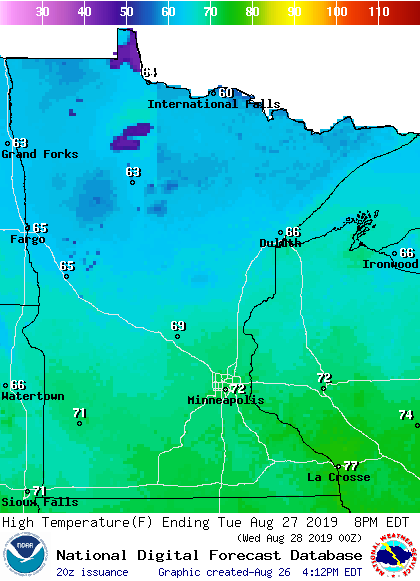
Metro area highs are projected be be around 70 degrees on Wednesday, followed by upper 70s Thursday and lower 70s on Friday and Saturday. It looks like we’ll have a shot at upper 70s Sunday and Labor Day, but check forecast updates.
Tropical Storm Dorian
The National Hurricane Center indicates that Tropical Storm Dorian will become a hurricane early Wednesday and the center of Dorian will approach Puerto Rico Wednesday afternoon:
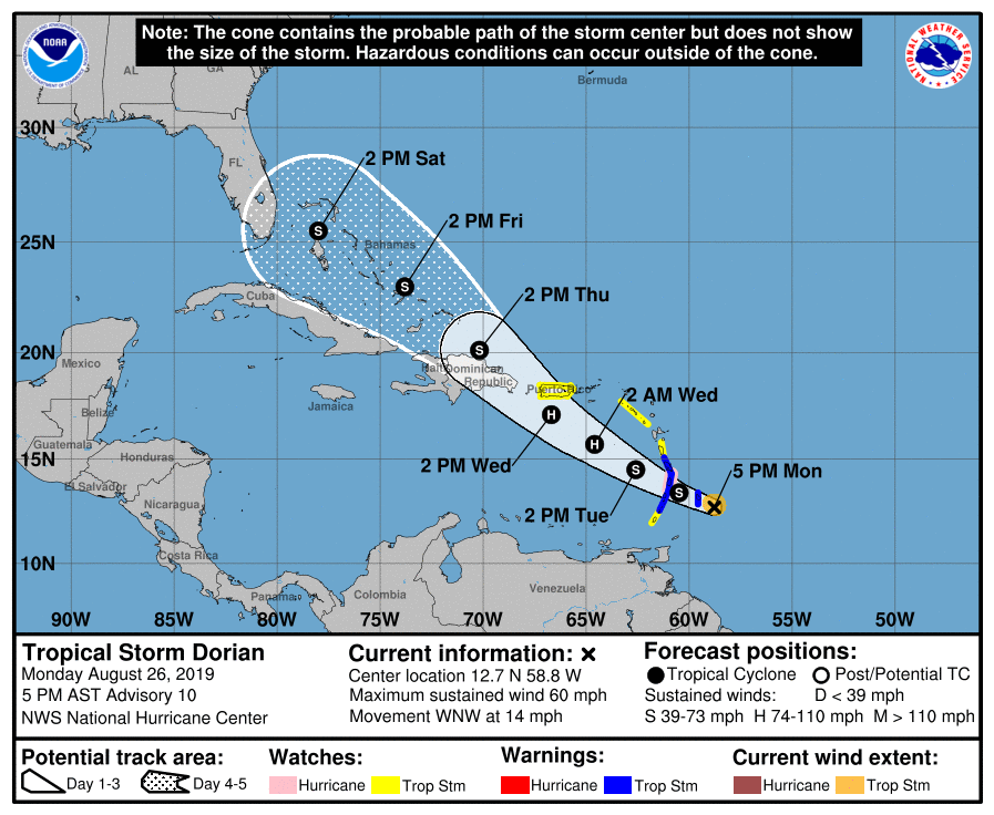
Here’s a portion of the Monday evening Tropical Storm Dorian update:

The National Hurricane Center will update its outlook for Dorian every few hours.

