
Storms at times Sunday and Monday; tropical southern and central Minnesota on Monday
Go Deeper.
Create an account or log in to save stories.
Like this?
Thanks for liking this story! We have added it to a list of your favorite stories.


Saturday certainly has been a great day to do some outdoor tasks or, better yet, have some fun outside. The comfortable sunshine for much of the day has compensated for temperatures just a tad on the cool side of normal.
Storm brewing to our west
A major storm to our west will continue to bring heavy snow and powerful winds to central and western Montana through the weekend. Snowfall totals will likely end up being measured in feet in and around Glacier National Park and east into the Plains around Cut Bank. Winter storm warnings have been issued for large parts of Montana as well as portions of Idaho and Washington.

The leading edge of the storm will trigger showers and thunderstorms in southern Minnesota Saturday night. The precipitation area will spread northeastward and should reach the Twin Cities area later Saturday night. These storms will not be severe.
Turn Up Your Support
MPR News helps you turn down the noise and build shared understanding. Turn up your support for this public resource and keep trusted journalism accessible to all.
Breezy Sunday
That storm center will shift to Wyoming and Colorado where it will reorganize on Sunday.
A tightening pressure gradient will generate gusty winds across Minnesota on Sunday, Clouds, wind and scattered showers and thunderstorms will make it feel cooler than the air temperatures. Expect highs from the low 50s in the north to the mid 60s in the south. The Twin Cities should have a high around 64 with gusty southeast winds.
Severe storms possible late Sunday
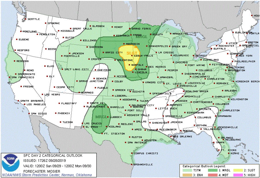
Considerable atmospheric instability and moisture will spread into the southwest corner of Minnesota Sunday afternoon. Strong and possibly severe thunderstorms are likely in that southwest corner by late Sunday afternoon or Sunday evening. A slight risk of severe weather has been posted for Sunday evening for southwestern Minnesota.
Showers and storms will track northeastward and should reach the general Twin Cities area Sunday night. Storms might lose a little support as they head into eastern portions of the state so a marginal risk of severe weather has been posted for the Twin Cities and central and northern Minnesota for Sunday night.
Steamy Monday for southern and central Minnesota
An impressive surge of heat and moisture for late September will bring very warm, very humid air to southern and central Minnesota for Monday. The Twin Cities and much of southern and central Minnesota will likely have high temperatures in the low 80s with tropical dew points in the low 70s. The record high temperature for the Twin Cities for September 30 is 87 (1897).
Meanwhile, northern Minnesota will be much cooler. The northwest corner of the state has a forecast high temperature of just the mid 50s on Monday.
Periods of showers and thunderstorms will continue for Monday and Monday night. Most of the state and western Wisconsin are included in a marginal risk of severe weather for that period.

Then a cooldown
Much cooler air from Canada will invade the state on Tuesday and bring us an Octoberlike week as we indeed begin October.

