
Chilly today, but milder temps the next two days; Tuesday snow potential?
Vibrant fall colors linger in parts of Minnesota
Go Deeper.
Create an account or log in to save stories.
Like this?
Thanks for liking this story! We have added it to a list of your favorite stories.


This hasn’t been declared as official yet, but it looks like the temperature at Minneapolis-St. Paul International Airport reached 32 degrees at 7:44 a.m. Thursday:

The last time that we hit 32 or colder at the airport was April 15.
According to the Twin Cities office of the National Weather Service, Oct.11 is the average date of our first 32-degree reading of autumn in the Twin Cities.
Temperature trends
Minnesota and western Wisconsin highs will be mainly in the 40s Thursday afternoon, with some 30s in parts of north-central and northeastern Minnesota.
Turn Up Your Support
MPR News helps you turn down the noise and build shared understanding. Turn up your support for this public resource and keep trusted journalism accessible to all.
Friday highs reach the 50s in many locations, with some 40s in the far north:
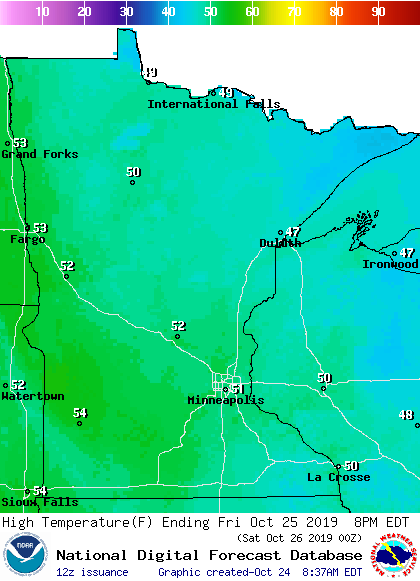
Saturday will be the mildest day in the next seven days, with highs in the 50s for most locations:
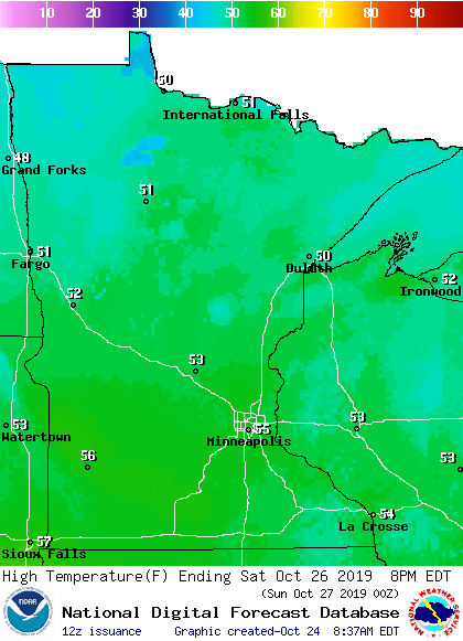
Highs retreat to the 40s on Sunday, with 30s in northern and west-central Minnesota:
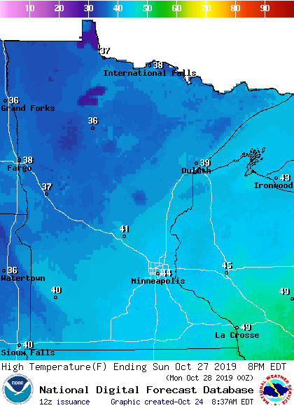
Twin Cities metro area highs only reach about 40 degrees on Monday, followed by 30s next Tuesday and Wednesday.
Rain and snow chances
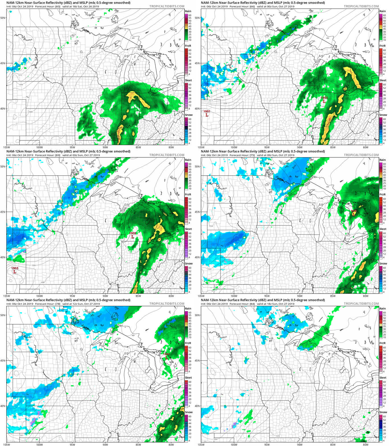
Northern Minnesota could see some rain showers late Saturday, with rain/snow showers possible Saturday night. Sunday morning will bring a chance of rain/snow showers in the north, with a passing rain shower possible in southern Minnesota and the Twin Cities.
The National Oceanic and Atmospheric Administration's Global Forecast System (GFS) model shows the potential precipitation pattern from Saturday afternoon through Sunday morning:
Listen for updated weather information on the MPR network, and you’ll also see updated weather info on the MPR News live weather blog.
Tuesday snow?
The European Centre for Medium-Range Weather Forecasts model shows snow for the Twin Cities next Tuesday, and it would be enough to shovel.
NOAA’s GFS model shows very little snow for the Twin Cities next Tuesday, but it does show some accumulating snow in northern Minnesota. It’ll be interesting to see if the models reach a consensus on next Tuesday’s weather over the next few days.
Crop report
The Minnesota Crop Progress & Condition report for the week ending Oct. 20 states:
Drier conditions prevailed this week slightly increasing the number of days suitable for fieldwork to 3.7 during the week ending October 20, 2019, according to USDA’s National Agricultural Statistics Service. Drier weather and cooler than normal temperatures allowed fields to dry somewhat, but the moisture content of crops is still measuring above optimal percent’s. Field activities for the week mostly revolved around harvesting crops.
Later in the report, which is issued by the United States Department of Agriculture and the National Agricultural Statistics Service in cooperation with the Minnesota Department of Agriculture, the following summary is given:
Eighty-nine percent of the corn crop was mature, 18 days behind last year and 10 days behind normal. Corn harvested for grain reached 11 percent, 17 days behind last year and 13 days behind the average. Corn harvested for silage reached 90 percent this week, 12 days behind average. Corn condition was rated 53 percent good to excellent, a slight improvement from the previous week. Nearly all soybeans have dropped their leaves, 6 days behind normal. Forty-two percent of the soybean crop has been harvested, 2 weeks behind average. Soybean condition was rated 53 percent good to excellent, remaining steady when compared to the previous week.
This chart shows how far behind the 5-year average the 2019 harvest is running:

Fall color update
According to the latest fall color report from the Minnesota Department of Natural Resources, fall colors are past peak in most areas, but remain vibrant in portions of the Twin Cities metro area and southeastern Minnesota:
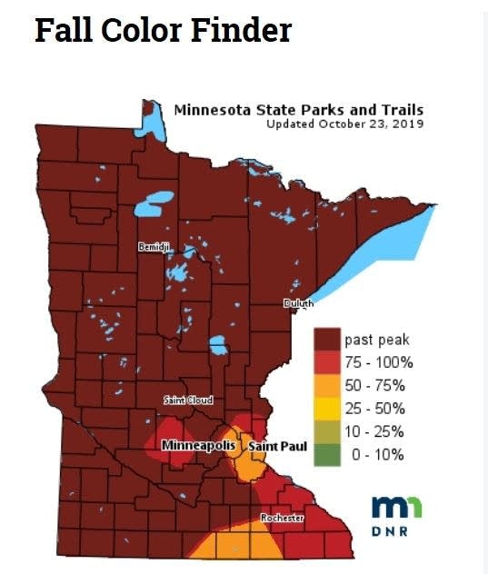
Keep in mind that the fall color report includes all deciduous trees, not just maples. A Wisconsin fall color report is also available.
Programming note
You can hear my live weather updates on Minnesota Public Radio at 7:49 a.m. Thursdays and Fridays and at 7:35 a.m., 9:35 a.m. and 4:35 p.m. each Saturday and Sunday.

