
Milder temps through Saturday; Tuesday snow update
Fall colors linger in some areas

Go Deeper.
Create an account or log in to save stories.
Like this?
Thanks for liking this story! We have added it to a list of your favorite stories.


I saw some vibrant fall colors during my travels through portions of Minneapolis and St. Paul over the past few days. Some trees have dropped most of their leaves, while the leaves on many trees are still transitioning from green to yellow, orange and red.
It’s nice to turn onto a street and see something like this:
According to the latest fall color report from the Minnesota Department of Natural Resources, fall colors are past peak in most of Minnesota, but beautiful fall colors can be found in portions of the Twin Cities metro area and south-central and southeastern Minnesota:
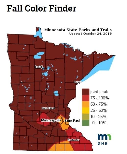
Keep in mind that the fall color report includes all deciduous trees, not just maples. A Wisconsin fall color report is also available.
Turn Up Your Support
MPR News helps you turn down the noise and build shared understanding. Turn up your support for this public resource and keep trusted journalism accessible to all.
Temperature trends
Minnesota and western Wisconsin highs will be mainly in the 50s this Friday afternoon, with some 40s in far northern Minnesota.
Saturday afternoon highs will reach well into the 50s in most areas, and a few spots in southwestern Minnesota could pop into the lower 60s:
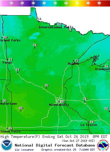
Sunday highs retreat to the 40s across southern and central Minnesota, with some 30s in the north:

Twin Cities metro area highs are projected to reach around 40 degrees on Monday, followed by mid- to upper 30s Tuesday and mid-30s Wednesday. It looks like we’ll top out in the lower 40s on Halloween, with temps dipping into the 30s for the evening ghosts and goblins.
Tuesday snow update
The European Centre for Medium-Range Weather Forecasts model is no longer showing a bunch of snow for the Twin Cities next Tuesday. That’s great news for those of us who haven’t finished our autumn outdoor projects!
Forecast models show a chance of rain/snow showers in the Twin Cities metro area next Monday night and Tuesday, with some light snow to our southeast and accumulating snow in parts of Iowa and southern Wisconsin.
The National Oceanic and Atmospheric Administration's Global Forecast System (GFS) model shows the potential precipitation pattern from Monday afternoon through Tuesday:
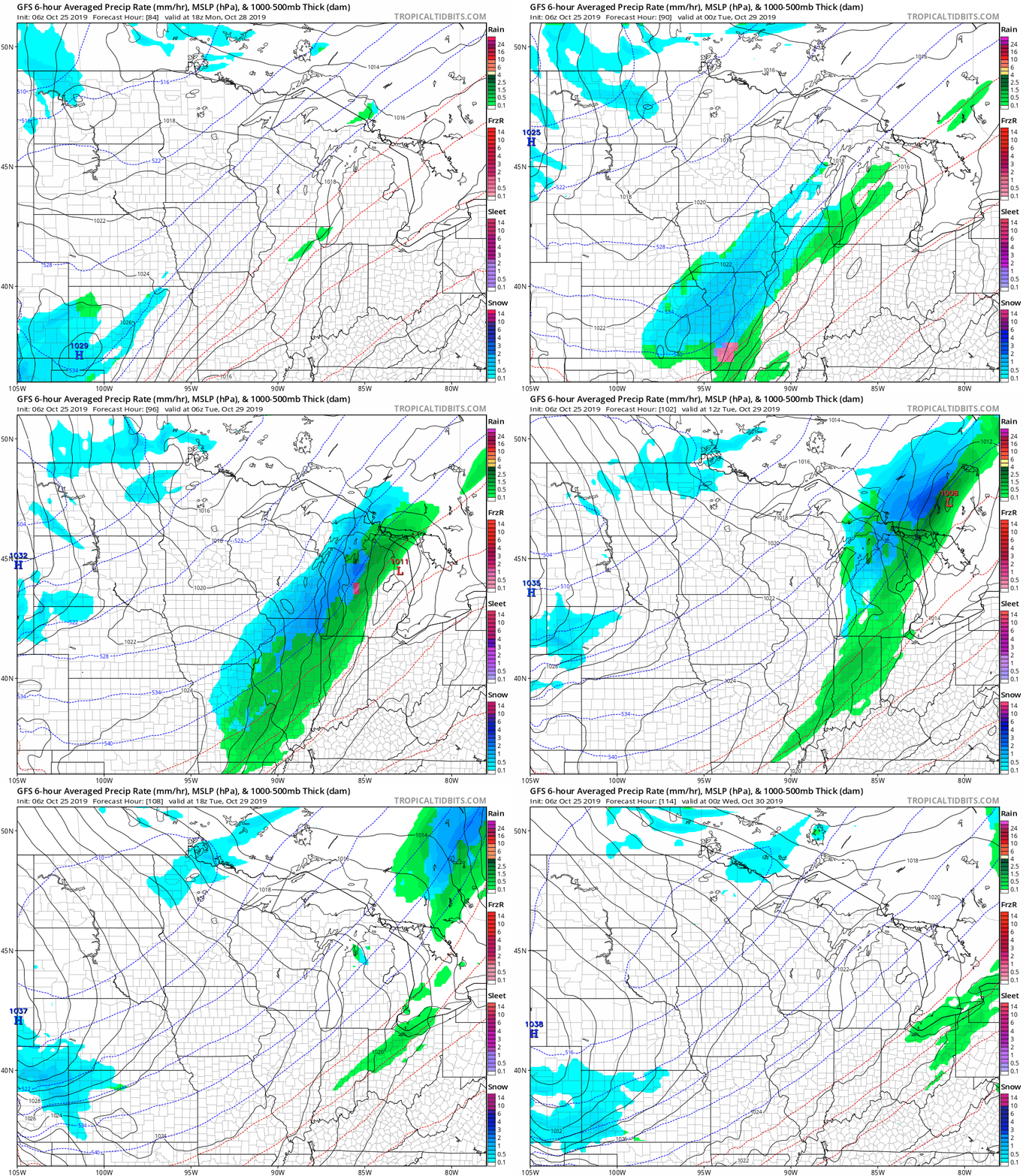
Parts of far northern Minnesota could also see a bit of snow accumulation Monday night and Tuesday.
Listen for updated weather information on the MPR network, and you’ll also see updated weather info on the MPR News live weather blog.
Duluth radar picks up huge flock of ducks
John Enger of MPR News posted an interesting story last week about ring-necked ducks being picked up by the Duluth National Weather Service office radar. The ducks were taking off from Rice Lake, south of McGregor, Minn.
Another radar sighting of ducks occurred yesterday:
NWS radar sometimes shows migrating bats in the San Antonio, Texas, area.
Programming note
You can hear my live weather updates on Minnesota Public Radio at 7:49 a.m. Thursdays and Fridays and at 7:35 a.m., 9:35 a.m. and 4:35 p.m. each Saturday and Sunday.

