
A very nice Saturday, sprinkle chance Sunday PM; snow in some areas on Tuesday
Update on Thursday and Friday weather
Go Deeper.
Create an account or log in to save stories.
Like this?
Thanks for liking this story! We have added it to a list of your favorite stories.


If you want to string the holiday lights or just play outdoors, Saturday’s weather will cooperate. High temperatures will be even be a few degrees warmer than average!
Temperature trends
Our average high temp is 37 degrees this time of year in the Twin Cities. We’re shooting for lower 40s this Saturday. Highs in the 40s are expected Saturday afternoon across roughly the southern half of Minnesota as well as west-central and southwestern Wisconsin. Highs will be in the 30s across much of northern Minnesota and northwestern Wisconsin.
Sunday highs reach the 40s in many areas, and could top 50 degrees in parts of the southwest:
Turn Up Your Support
MPR News helps you turn down the noise and build shared understanding. Turn up your support for this public resource and keep trusted journalism accessible to all.
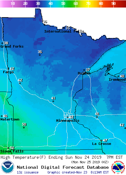
Most of northern Minnesota will reach the 30s Sunday afternoon.
Monday highs will feature 40s south and 30s north:
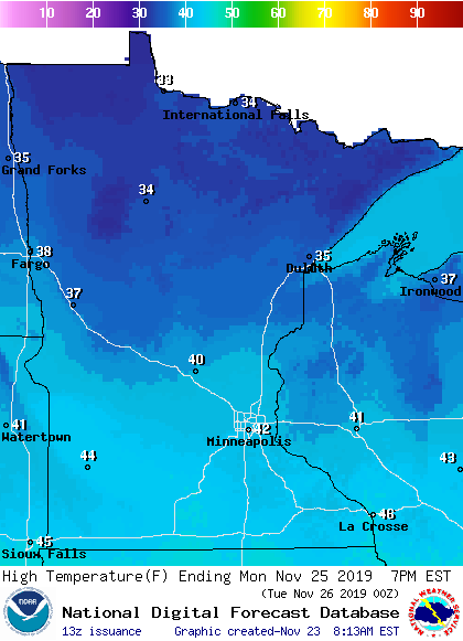
Twin Cities metro area highs are projected to be in the mid to upper 30s on Tuesday, followed by mid 30s Wednesday and Thursday and upper 30s Friday.
Rain and snow chances
One forecast model shows a chance of rain and snow showers in far northern Minnesota Sunday afternoon into Sunday night. Western Minnesota could see a few Sunday afternoon sprinkles, with a chance of a sprinkle late Sunday afternoon/Sunday evening in the Twin Cities metro area.
The next strong low-pressure system is expected to spin to our southeast on Tuesday and Tuesday night. Southeastern Minnesota could see some snow if it takes that track, with heavier snow amounts possible on parts of Iowa and southern/eastern Wisconsin.
National Oceanic and Atmospheric Administration's Global Forecast System (GFS) model shows this potential precipitation pattern next Tuesday through Wednesday morning:
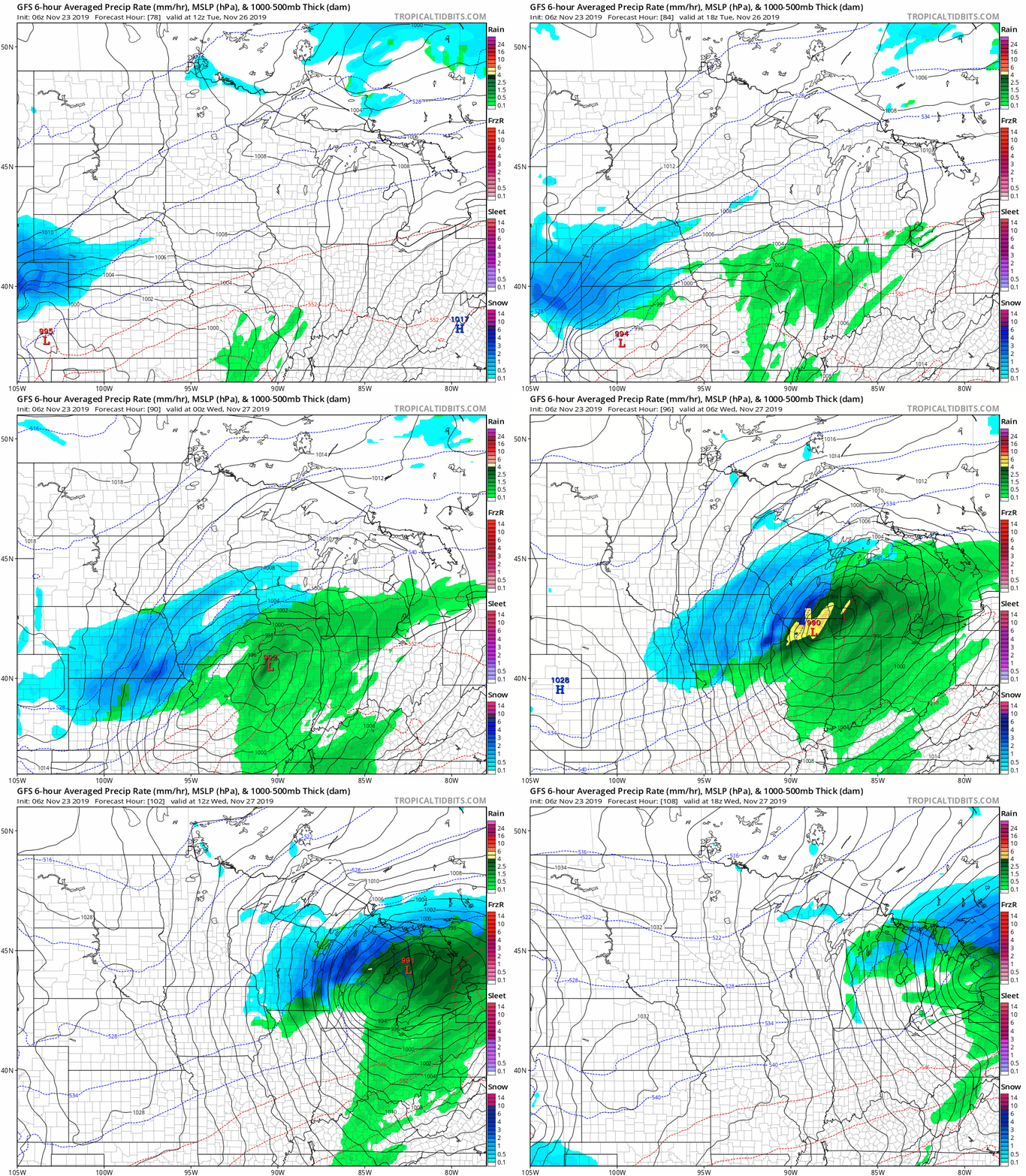
The Twin Cities could see a sprinkle or flurry Tuesday afternoon and evening, but check forecast updates; a northward shift in the track would give us some accumulating snow late Tuesday.
Listen for updated weather information on the MPR network, and you’ll also see updated weather info on the MPR News live weather blog.
As for Thanksgiving, there still isn’t a lot of agreement among the forecast models. Some forecast models give Minnesota and western Wisconsin a chance of rain showers and snow showers Thursday PM, with a better chance of rain and snow on Friday. Check forecast updates as we get closer to Thanksgiving.
Precipitation record is in sight
Our 2019 precipitation total (rain plus the water content of snow) at Minneapolis-St. Paul International Airport is 40.03 inches. We’re only three-tenths of an inch from surpassing the wettest year on record in the Twin Cities, which was 40.32 inches in 2016:

We still have the rest of November and all of December to break that record!
Programming note
You can hear my live weather updates on Minnesota Public Radio at 7:35 a.m., 9:35 a.m. and 4:35 p.m. each Saturday and Sunday.

