
Heavy snow and strong winds Tuesday P.M. into early Wednesday; difficult travel
Another significant snow possible late Friday into Saturday
Go Deeper.
Create an account or log in to save stories.
Like this?
Thanks for liking this story! We have added it to a list of your favorite stories.


In the Twin Cities metro area, we see an average of 9.3 inches of snow during the month of November. So far this November, we’ve only tallied 1.6 inches of snow at Minneapolis-St. Paul International Airport.
I guess we’re overdue for some significant snow!
Forecast models are coming into agreement on a significant winter storm for much of southern and central Minnesota and western Wisconsin this Tuesday into early Wednesday. The National Oceanic and Atmospheric Administration's Global Forecast System (GFS) model shows this precipitation pattern Tuesday through Wednesday:

The storm track could change a bit as we get closer to Tuesday, but it’s safe to say that there will be a fairly wide swath of significant snow.
Turn Up Your Support
MPR News helps you turn down the noise and build shared understanding. Turn up your support for this public resource and keep trusted journalism accessible to all.
The National Weather Service has posted a winter storm watch for much of central and southern Minnesota and western Wisconsin:

The winter storm watch starts at 6 p.m. Tuesday in the Twin Cities and west-central Wisconsin, and it continues until noon on Wednesday. The watch is for a combination of heavy snow, strong winds and difficult travel conditions.
The Twin Cities could see 5 to 7 inches of snow from this storm. The winter storm watch starts at 9 a.m. Tuesday and runs until 6 a.m. Wednesday in southwestern Minnesota. The winter storm watch starts at 3 p.m. Tuesday in Mankato and runs to noon on Wednesday.
Listen for updated weather information on the MPR network, and you’ll also see updated weather info on the MPR News live weather blog.
You can click on your location at the Twin Cities NWS site for detailed forecast updates. If you have travel plans, you can check Minnesota road conditions and Wisconsin road conditions.
What about the Euro?
The European Centre for Medium-Range Weather Forecasts model (ECMWF) is also showing substantial snow for the Twin Cities Tuesday evening into early Wednesday:

Don’t be alarmed by those temperatures, they’re using the Celsius temperature scale, not our familiar Fahrenheit scale.
The Euro model gives Minneapolis a total of 14.6 millimeters (equal to .575 inches) of water in the snow that falls from Tuesday afternoon through Wednesday morning. At a 10-to-1 snow-to-water ratio, it would yield 5.75 inches of snow.
The European model, like the GFS model, shows the heaviest snow Tuesday evening through the overnight hours of Tuesday night.
Snow-to-water ratios will vary, depending on the temperature profile in the atmosphere.
Wintry mix Sunday night and Monday up north
I should mention that far northern Minnesota will be dealing with a wintry mix of rain, snow and possibly some light freezing rain overnight Sunday night and on Monday. Take care if you are traveling in that area:
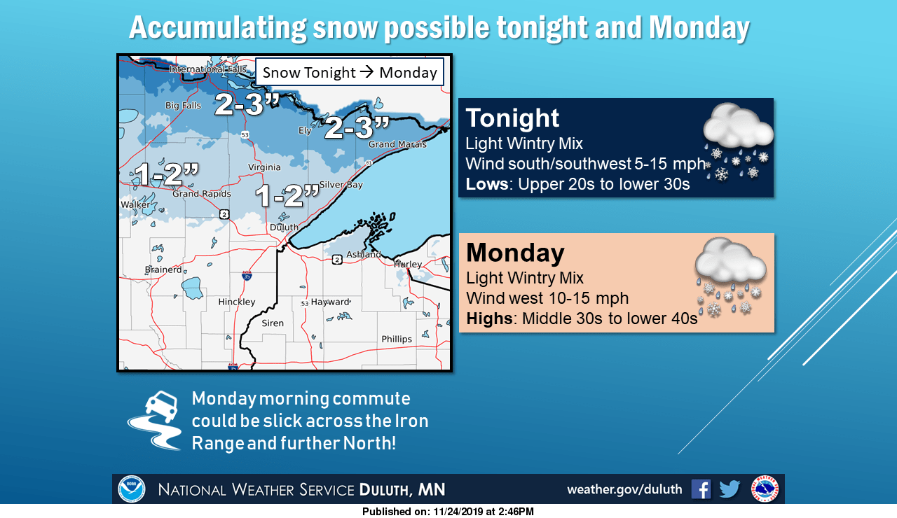
Note: “tonight” in the NWS graphic refers to Sunday evening and the overnight hours of Sunday night.
Friday/Saturday storm?
The GFS model shows another strong winter storm moving into Minnesota late Friday and lingering into Saturday. The heaviest snow from that one may fall over central and northern Minnesota, with a rain/snow mix and lighter snow accumulations in the south.
A small shift in that storm track could move the heavy snow band. Stay tuned.

