
Another cold start Wednesday; warmer temperatures and snow Thursday
More cold air returns for the weekend.
Go Deeper.
Create an account or log in to save stories.
Like this?
Thanks for liking this story! We have added it to a list of your favorite stories.


After a dangerously cold start, temperatures warm slightly on Wednesday ahead of a snowstorm that could slow the commute Thursday morning.
Wednesday
Wednesday started with subzero temperatures across the state, and wind chills often minus 20 to minus 30 degrees and even slightly colder at times. Northern and central Minnesota are under a wind chill advisory until noon.
Temperatures as of 8:30 a.m.:
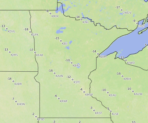
An approaching snowstorm will help draw in warmer air, so temperatures will rise though the day.
Turn Up Your Support
MPR News helps you turn down the noise and build shared understanding. Turn up your support for this public resource and keep trusted journalism accessible to all.
For most of Minnesota, temperatures keep rising in the evening and overnight into Thursday. That means not only will Thursday be warmer, but some places will set their Wednesday high temperatures at the end of the day.

By Wednesday evening, a quick-moving snowstorm starts moving into western Minnesota, then spreading across the state.
Thursday snow
The snow system that moves in Wednesday night will already be through most of the state by midday Thursday, and it brings predominantly light snow.
The heaviest snow is likely to be a corridor in eastern Minnesota, just north of Interstate 94, with 3 to 5 inches possible. Those areas are under a winter storm advisory from 10 p.m. Wednesday night through noon Thursday.
This graphic shows areas under the winter storm advisory highlighted in purple:

For the Twin Cities, it should stay light at 1 to 2 inches, but the timing will slow the Thursday morning commute.

Temperatures will be less cold on Thursday, although still below average, ranging mostly from 10 to 25 degrees across the state.
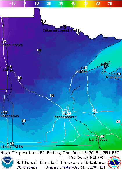
More snow possible Friday
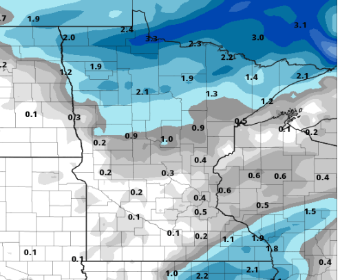
Another system moves across Minnesota Friday into early Saturday. It will move through more slowly than Thursday’s snow, but the snow remains very light for most.
Many places will receive less than 1 inch of snow, except for northern Minnesota, where 2 to 4 inches are possible near the border by Saturday morning.
That system does bring back in the cold air. Temperatures will fall through the day for much of the state on Saturday, and by Sunday we return to highs only in the single digits.
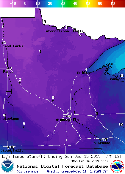
Sunday and Monday morning could see some lows that are subzero.
After Sunday, next week is currently looking quieter, both in terms of snowfall and with temperatures remaining more seasonable.
Programming note
You can hear my live weather updates on Minnesota Public Radio at 7:48 a.m. Monday through Friday morning.

