Chilly Wednesday; then warming storm-free into next week
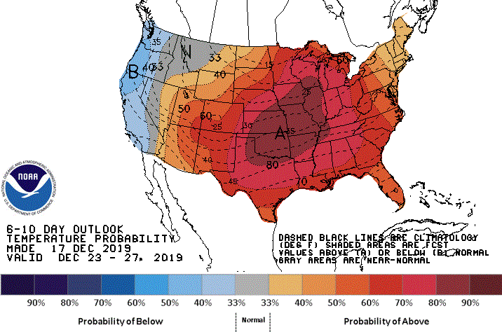
Tuesday’s cold front ushered in a dome of cold Canadian high pressure to present a one-day speedbump in our road to milder weather.
Temperatures dropped into the 20s below zero across most of north-central and northeastern Minnesota early Wednesday morning. Big Fork and Cook reported temperatures of 31 below at 4 a.m.
While winds have been generally quite light overnight, any wind will produce a nasty wind chill at those temperatures. So a wind chill warning has been posted until 10 a.m. Wednesday for Lake and Cook counties in the Arrowhead.
The urban heat island prevented the core of the Twin Cities from getting especially cold. The official low temperature up to 6 a.m. was 2 below while many suburbs were cooling to close to 10 below. The record low for the Twin Cities for Dec. 18 is 24 below, set in 1983.
Create a More Connected Minnesota
MPR News is your trusted resource for the news you need. With your support, MPR News brings accessible, courageous journalism and authentic conversation to everyone - free of paywalls and barriers. Your gift makes a difference.
Chilly Wednesday
Clouds advancing across the state Wednesday morning will gradually give way to some sun from west to east later in the day.
Expect afternoon high temperatures just around 5 to 10 degrees in the Arrowhead, teens for most of the state and up to the mid-20s in southwestern Minnesota. The Twin Cities should have a high around 16 with a northwest wind increasing to 5-15 mph.
Much milder beginning Thursday
Our moderating trend will resume on Thursday as the cold high pressure heads east. Afternoon high temperatures into the upper teens in the northeast, the 20s for most Minnesotans and even low 30s in the balmy southwest will be welcome. The Twin Cities should reach a seasonable 26 degrees.
Turning almost balmy
The flow pattern will continue to send mild air toward Minnesota into next week before colder air arrives from Canada again later in the week. The Twin Cities should see high temperatures into the 30s from Friday through at least Tuesday.
Overall, the Climate Prediction Center’s six- to 10-day temperature outlook calls for the strong likelihood of higher-than-normal temperatures across much of the central and eastern United States, including our part of the world.
No upcoming storms
Other than a little Light snow for the Arrowhead on Friday, the precipitation pattern for the Upper Midwest is likely to remain unusually benign through about Tuesday, Christmas Eve.
The uneventful pattern is likely to begin breaking down later next week but timing is uncertain.