
Unusually warm this Sunday; no more arctic plunges in 2019
Chance of fog/freezing fog early Sunday morning
Go Deeper.
Create an account or log in to save stories.
Like this?
Thanks for liking this story! We have added it to a list of your favorite stories.


Astronomical winter begins at 10:19 p.m. CST this Saturday, Dec. 21. We can watch the midday sun angle gradually become higher above the horizon over the next six months. Isn’t that a nice thought?
By the way, meteorological winter started on Dec. 1. Meteorologists take the three coldest months of the year and label them “winter”, and we label the three warmest months (June, July, August) “summer”. We fill in the gaps with “spring” and “autumn”. I know, winter is longer than three months in Minnesota and Wisconsin, but starting winter on Dec. 1 rather than Dec. 21 seems closer to our weather reality.
Just hours before the winter solstice, we saw a high of 44 degrees Saturday afternoon at Minneapolis-St. Paul International Airport. That was 19 degrees warmer than our average Dec. 21 Twin Cities high of 25 degrees.
Temperature trends
Turn Up Your Support
MPR News helps you turn down the noise and build shared understanding. Turn up your support for this public resource and keep trusted journalism accessible to all.
Highs in the 40s are expected Sunday across much of the southern half of Minnesota and parts of western Wisconsin. Most of northern Minnesota will see highs in the 30s. Twin Cities metro area highs are expected to reach the mid 40s Sunday afternoon.
Most of us will have highs in the 30s on Monday:
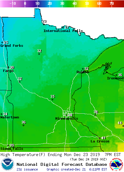
I wouldn’t be surprised to see a stray 40 Monday afternoon in the south metro or southeastern Minnesota.
Highs in the 30s are on tap for Tuesday:
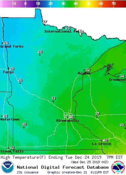
Twin Cities metro area highs are projected to reach the mid 30s Wednesday and Thursday.
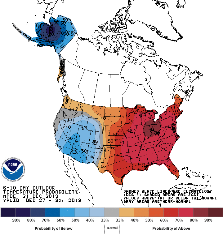
Warmer than normal temps could linger right through the end of December. The Climate Prediction Center of the National Weather Service shows a strong tendency toward warmer than normal temperatures across Minnesota and Wisconsin for Dec. 27 through Dec. 31:
Rain and snow chances
I’ll start with a mention of possible fog and patchy drizzle/freezing drizzle early Sunday in parts of Minnesota and western Wisconsin.
Quiet weather is expected on Monday and Tuesday. Some forecast models show a chance of rain showers and snow showers for Minnesota and western Wisconsin Christmas Day and also on Thursday. Check forecast updates to see if the weather pattern changes.
You can hear updated weather information on the MPR network, and you’ll see updated weather info on the MPR News live weather blog.
Programming note
You can hear my live weather updates on MPR News at 7:35 a.m., 9:35 a.m. and 4:35 p.m. each Saturday and Sunday.

