
March-like Sunday temps; update on rain and snow chances this coming week
A look back at the Incredible cold temps of December 1983
Go Deeper.
Create an account or log in to save stories.
Like this?
Thanks for liking this story! We have added it to a list of your favorite stories.


Our average high temperature is 25 degrees this time of year in the Twin Cities metro area. We were already warmer than that at sunrise this Sunday, and we could top out in the upper 40s in parts of the metro area this afternoon. Those are temperatures more typical of the third week of March than the third week of December. Temps back off a bit this coming week, but they’ll still be milder than normal for December.
Temperature trends
Highs in the 40s are expected Sunday across much of the southern half of Minnesota and parts of western Wisconsin. We could even see a stray 50 degree reading somewhere in southwestern Minnesota. Most of northern Minnesota will see highs in the 30s.
Most of us will have highs in the 30s on Monday, with some 20s in far northwestern Minnesota:
Turn Up Your Support
MPR News helps you turn down the noise and build shared understanding. Turn up your support for this public resource and keep trusted journalism accessible to all.
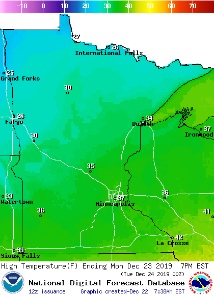
Tuesday highs will also be mainly in the 30s, with 20s in the northwest:
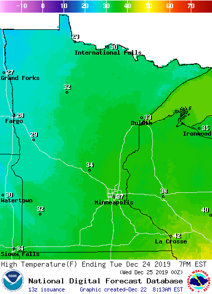
Twin Cities metro area highs are projected to reach the mid 30s Wednesday and Thursday, followed by lower 30s on Friday.
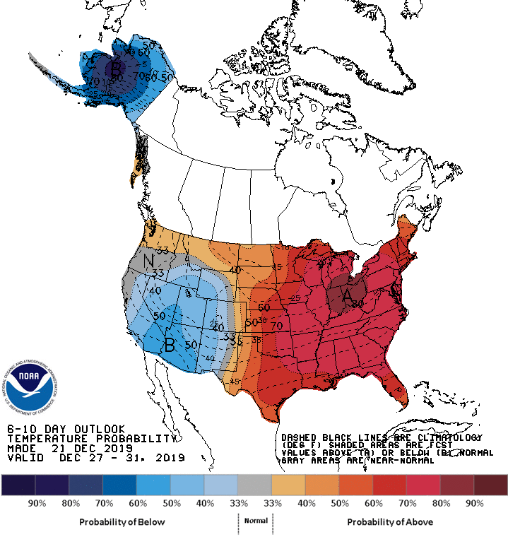
Warmer than normal temps could linger right through the end of December. The Climate Prediction Center of the National Weather Service shows a strong tendency toward warmer than normal temperatures across Minnesota and Wisconsin for the period from Dec. 27 through Dec. 31:
One forecast model shows a dip in temps on Dec. 30 followed by a rebound on Dec. 31, but the five-day period is expected to be warmer than normal.
Rain and snow chances?
Northeastern Minnesota and northwestern Wisconsin had some areas of fog and the chance of patchy freezing fog Sunday morning, and that could happen again late Sunday night and early Monday in parts of Minnesota and western Wisconsin.
Quiet weather is expected most of Monday and Tuesday. There’s a chance of light snow showers in northern Minnesota on Tuesday. Some forecast models show a chance of rain showers and snow showers in Minnesota and western Wisconsin on Christmas Day and also on Thursday…check forecast updates to see if the weather pattern changes.
You can hear updated weather information on the MPR network, and you’ll see updated weather info on the MPR News live weather blog.
Incredibly cold in December of 1983
On this date in 1983, the Twin Cities low temp was -20 and the high temp that day was only -12. The next day was even colder, with a low of -25 and a high of -17 in the Twin Cities:
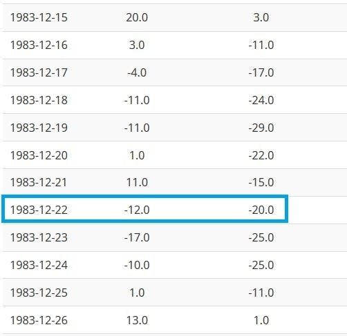
High temps are in the left column and low temps are in the right-hand column of the graphic. The Twin Cities had ten consecutive days with highs below zero in Dec. 1983, with the final one on Christmas Day.
There was plenty of snow on the ground that December. The Twin Cities tallied 30.4 inches of snow in November of 1983 and another 21 inches in December of 1983. The 1983-1984 snow season brought 98.6 inches of snow to the Twin Cities, which is still the most snow of any snow season in Twin Cities weather records!
Ice safety
If you plan to venture out onto a lake today or in the coming days, here’s a reminder about ice safety.
The ice thickness guidelines from the Minnesota Department of Natural Resources indicate that at least 4 inches of clear new ice are needed to support a human:

Here are additional ice-thickness guidelines from the Minnesota DNR:
UNDER 4" - STAY OFF
4" - Ice fishing or other activities on foot
5" - 7" - Snowmobile or ATV
8" - 12" - Car or small pickup
12" - 15" - Medium truckMany factors other than thickness can cause ice to be unsafe.
White ice or "snow ice" is only about half as strong as new clear ice. Double the above thickness guidelines when traveling on white ice.The DNR does not measure ice thickness on Minnesota lakes. Your safety is your responsibility. Check ice thickness at least every 150 feet.
Temperature, snow cover, currents, springs and rough fish all affect the relative safety of ice. Ice is seldom the same thickness over a single body of water; it can be 2 feet thick in one place and 1 inch thick a few yards away. Check the ice at least every 150 feet.
Additional info on ice safety can be found here.
Programming note
You can hear my live weather updates on MPR News at 7:35 a.m., 9:35 a.m. and 4:35 p.m. each Saturday and Sunday.

