
Snow clips Minnesota on Friday, with another round on Sunday
Saturday remains quiet between weather systems
Go Deeper.
Create an account or log in to save stories.
Like this?
Thanks for liking this story! We have added it to a list of your favorite stories.


Light snow moves across Minnesota Friday, with high winds and more possible snow on Sunday. Temperatures vary between seasonable and above average through Monday.
Friday’s weather
A weak area of low pressure skirts across the southwest corner of Minnesota Friday, bringing predominantly light snow to almost all of the state. Northwest Minnesota may miss the snow entirely. Light snow is already pushing into western Minnesota as of Friday morning.
Snow totals for most places, including the Twin Cities will be less than 1 inch. However, southwestern Minnesota could see widespread totals up to 2 inches. Then, a corridor along the Upper Minnesota River Valley, especially just south of Redwood Falls to Mankato, could see some isolated reports up to 4 inches.
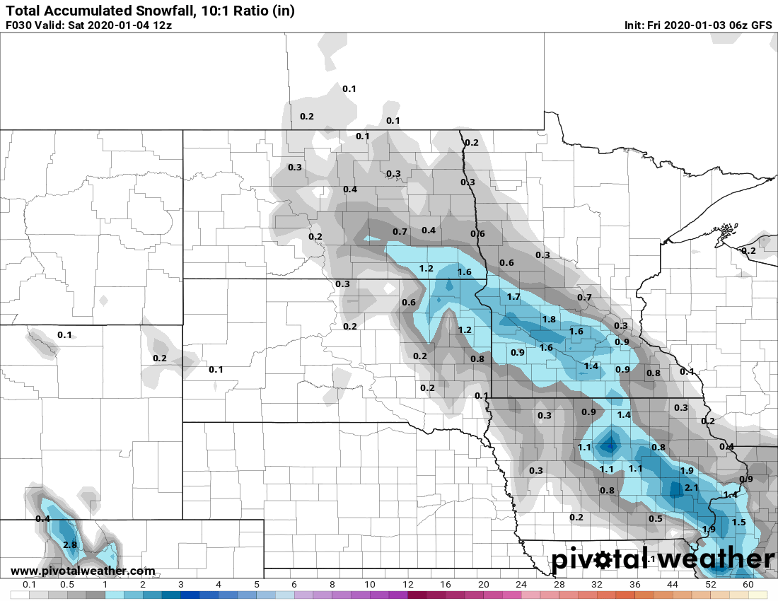
For the area seeing the higher snow totals, snow could come through quickly in the afternoon reducing visibility, so be prepared for slower travel.
Turn Up Your Support
MPR News helps you turn down the noise and build shared understanding. Turn up your support for this public resource and keep trusted journalism accessible to all.
Highs Friday will range in the 20s and 30s, but some locations will set those highs in the morning.
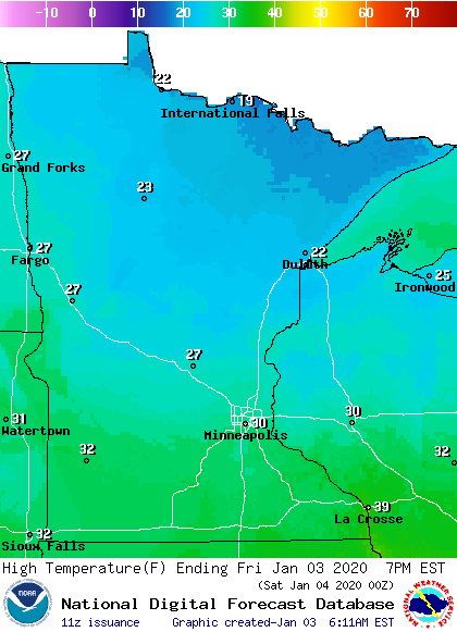
Temperatures Friday morning range from teens in northern Minnesota to mid-30s in southern Minnesota.
Most of southern Minnesota will see temperatures that remain steady through the morning or even fall slightly by afternoon. For example, the Twin Cities will likely go from the low 30s Friday morning to the upper 20s by afternoon.
Weekend forecast
Saturday will be the quieter day between weather disturbances. Temperatures will be seasonable to slightly above average, with highs mostly in the 20s. Skies will be partly sunny, except northern Minnesota which will remain mostly cloudy.
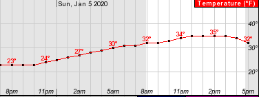
Already by the Saturday evening temperatures will start rising and they climb through the overnight as another system approaches Minnesota. Highs will be in the 30s on Sunday. Here is how temperatures are expected to warm for the Twin Cities Saturday night:
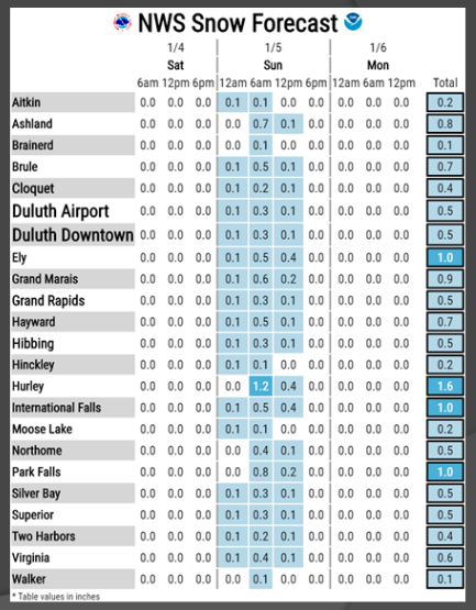
As temperatures climb overnight Saturday, a dusting of snow also starts to move across the state, with snow chances through Sunday morning. There is also a slight chance northern Minnesota could see some light freezing rain mix in with the snow.
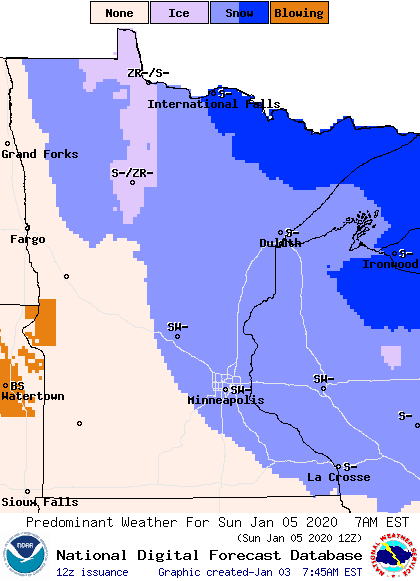
Snow could linger through Sunday afternoon for the Arrowhead. The best chance for accumulation is for northern Minnesota to get up to 1 inch with a couple of isolated areas getting 2 inches.
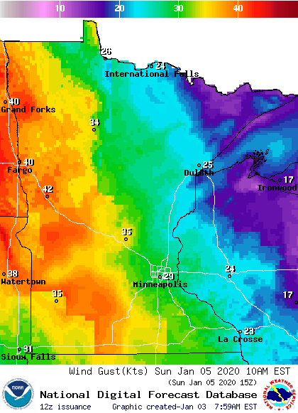
Winds will also increase Sunday as a cold front moves through, with many places that could have winds gust over 40+ mph, particularly Sunday morning and early afternoon.
Early next week
Behind the cold front that moves through on Sunday, temperatures will be cooler, but more seasonable for January.
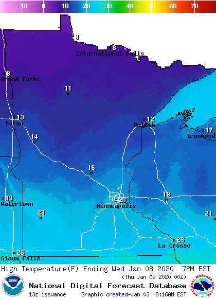
Highs will be in the teens and 20s on Monday, and by Tuesday and Wednesday, northern Minnesota may only see highs in the single digits.
Another round of snow will likely move across the state late Monday into early Tuesday. However, that too will stay very light. Currently, it looks like most of the state would get less than 1 inch.
Programming note
You can hear my live weather updates on Minnesota Public Radio at 7:48 a.m. Monday through Friday morning.

