
Comfortable weekend temps, but windy on Sunday
Ice safety reminder
Go Deeper.
Create an account or log in to save stories.
Like this?
Thanks for liking this story! We have added it to a list of your favorite stories.


We won’t have any arctic air to deal with this weekend, which is nice.
Temperature trends
Our average high temp is 24 degrees in the Twin Cities metro area this time of year. We’re expected to reach the upper 20s in the metro area this Saturday afternoon, and highs in the 20s will be common across much of Minnesota and western Wisconsin. A few spots in far southern Minnesota could reach the lower 30s.
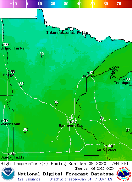
Sunday highs reach the 30s in most areas, with a few upper 20s in far northern Minnesota:
Turn Up Your Support
MPR News helps you turn down the noise and build shared understanding. Turn up your support for this public resource and keep trusted journalism accessible to all.
Winds will be strong on Sunday, gusting over 40 mph in many areas by afternoon.
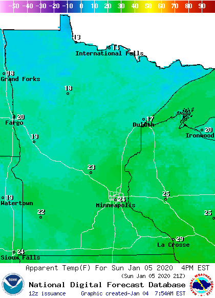
The strong winds will generate wind chills in the teens north and 20s south Sunday afternoon:
Twin Cities metro area highs are projected to reach the lower 30s on Monday, followed by lower 20s Tuesday and mid 20s Wednesday. Metro highs rebound to the lower 30s on Thursday, then dip back to the lower 20s on Friday.
Snow chances
Far northern Minnesota and parts of northern Wisconsin could see occasional Saturday flurries.
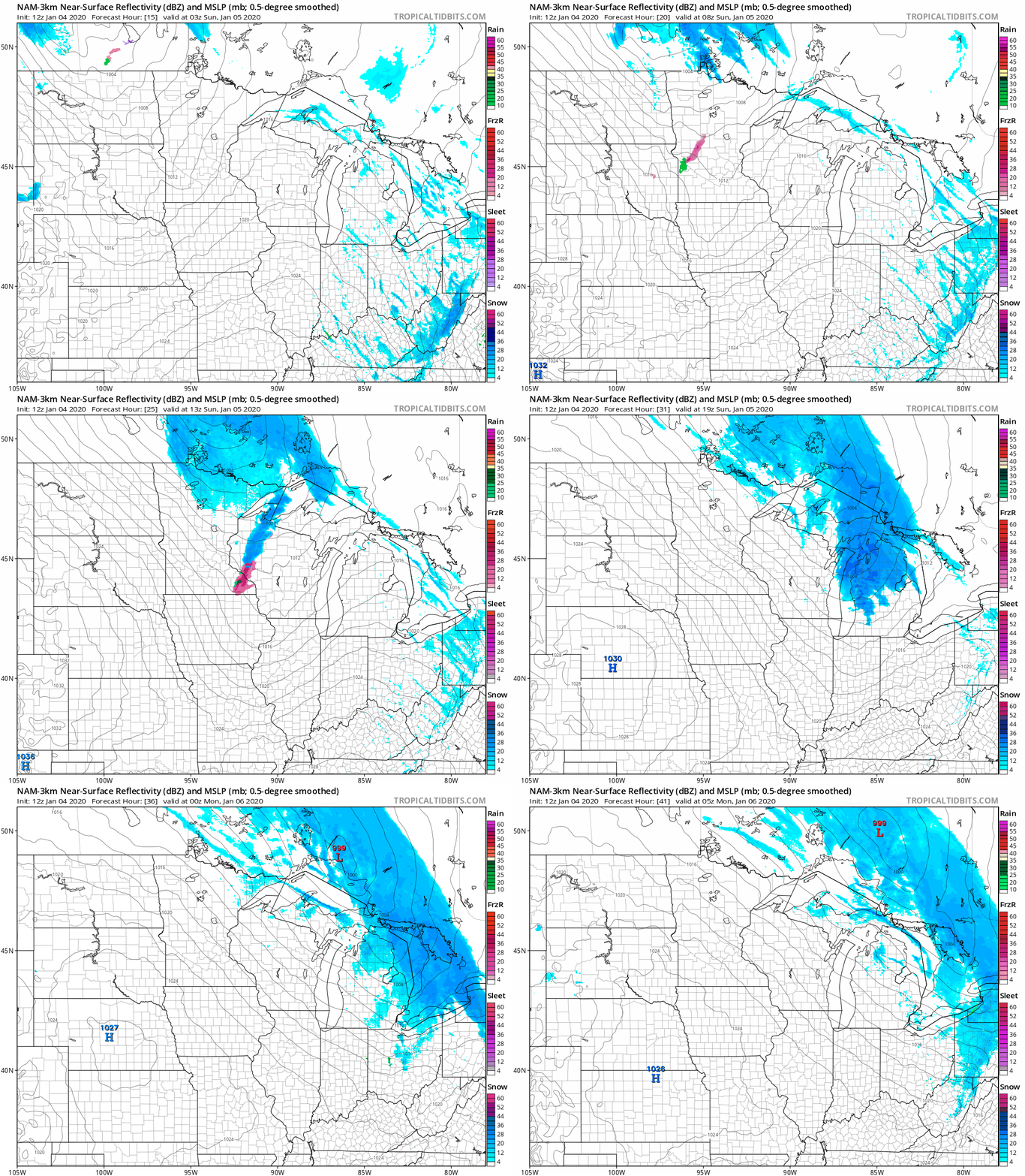
There’ll be a chance of snow showers in northern Minnesota and northwestern Wisconsin late Saturday night, with periods of light snow likely in those same areas on Sunday. Central Minnesota, the Twin Cities metro area and west-central Wisconsin could see a batch of light snow or a brief wintry mix move through early Sunday morning,
The National Oceanic and Atmospheric Administration’s North American Mesoscale forecast model shows the potential precipitation pattern Saturday night through Sunday evening:
You can hear updated weather information on the MPR network, and you’ll see updated weather info on the MPR News live weather blog.
Snow depths
It’s the weekend, and some people have plans to go out and play in the snow.
Here’s the Minnesota snow depth map, courtesy of the Minnesota State Climatology Office and the Minnesota Department of Natural Resources:

Snow depths range from two inches or less in far southern Minnesota to 18 to 24 inches across a wide swath of northern Minnesota. It looks there’s even a tiny spot of 24 to 30 inches in northeastern Minnesota.
Most of Minnesota has plenty of snow on the ground for cross-country skiers, sledders and snowboarders. There’s enough snow cover for snowmobiling in much of central and northern Minnesota.
Ice safety
If you plan to venture out onto a lake this weekend, here’s a reminder about ice safety.
The ice thickness guidelines from the Minnesota Department of Natural Resources indicate that at least 4 inches of clear new ice are needed to support a human:

Here are additional ice-thickness guidelines from the Minnesota DNR:
UNDER 4" - STAY OFF
4" - Ice fishing or other activities on foot
5" - 7" - Snowmobile or ATV
8" - 12" - Car or small pickup
12" - 15" - Medium truckMany factors other than thickness can cause ice to be unsafe.
White ice or "snow ice" is only about half as strong as new clear ice. Double the above thickness guidelines when traveling on white ice.The DNR does not measure ice thickness on Minnesota lakes. Your safety is your responsibility. Check ice thickness at least every 150 feet.
Temperature, snow cover, currents, springs and rough fish all affect the relative safety of ice. Ice is seldom the same thickness over a single body of water; it can be 2 feet thick in one place and 1 inch thick a few yards away. Check the ice at least every 150 feet.
Additional info on ice safety can be found here.
Programming note
You can hear my live weather updates on MPR News at 7:35 a.m., 9:35 a.m. and 4:35 p.m. each Saturday and Sunday.

