
A windy Sunday, with some icy spots
Minnesota has plenty of snow cover
Go Deeper.
Create an account or log in to save stories.
Like this?
Thanks for liking this story! We have added it to a list of your favorite stories.


A wintry mix of light snow, light freezing rain and sleet moved through parts of eastern Minnesota and western Wisconsin early Sunday morning. It left a thin icy glaze on some roads, sidewalks and driveways. Several crashes and spin-outs have been reported on Twin Cities metro area highways this Sunday morning. Conditions should improve as temperatures warm a few degrees Sunday afternoon.
You can hear updated weather information on the MPR network, and you’ll see updated weather info on the MPR News live weather blog.
The Minnesota Department of Transportation will have reports on road conditions. Wisconsin road conditions can be found here.
Snow chances
Turn Up Your Support
MPR News helps you turn down the noise and build shared understanding. Turn up your support for this public resource and keep trusted journalism accessible to all.
The best chance of some periods of light snow Sunday afternoon will be in north-central and northeastern Minnesota and parts of northwestern Wisconsin.
The National Oceanic and Atmospheric Administration’s North American Mesoscale forecast model shows the potential precipitation pattern Sunday afternoon and evening:

A stray flurry or sprinkle will be possible elsewhere in Minnesota and western Wisconsin.
Winds
It’ll be a windy Sunday, and wind advisories cover most of Minnesota and far western Wisconsin:
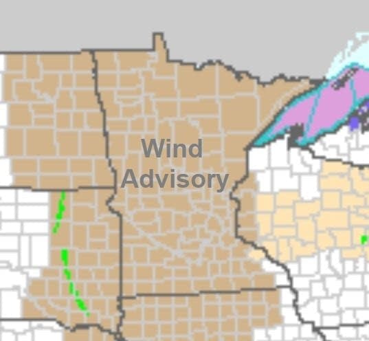
Here are details of the wind advisory, which runs until 4 p.m. this Sunday afternoon in the Twin Cities:
URGENT - WEATHER MESSAGE National Weather Service Twin Cities/Chanhassen MN 250 AM CST Sun Jan 5 2020 MNZ043>045-050>053-059>063-068>070-076-077-083-084-051700- /O.EXT.KMPX.WI.Y.0001.200105T1300Z-200105T2200Z/ Morrison-Mille Lacs-Kanabec-Benton-Sherburne-Isanti-Chisago- Wright-Hennepin-Anoka-Ramsey-Washington-Carver-Scott-Dakota- Le Sueur-Rice-Blue Earth-Waseca- Including the cities of Little Falls, Princeton, Mora, Foley, Elk River, Cambridge, Center City, Monticello, Minneapolis, Blaine, St Paul, Stillwater, Chaska, Shakopee, Hastings, Le Sueur, Faribault, Mankato, and Waseca 250 AM CST Sun Jan 5 2020 ...WIND ADVISORY NOW IN EFFECT FROM 7 AM THIS MORNING TO 4 PM CST THIS AFTERNOON... * WHAT...Northwest winds 30 to 35 mph with gusts up to 50 mph expected. * WHERE...Portions of central, east central and south central Minnesota. * WHEN...From 7 AM this morning to 4 PM CST this afternoon. The strongest winds will occur after 10 AM. * IMPACTS...Gusty winds could blow around unsecured objects. Tree limbs could be blown down and a few power outages may result. PRECAUTIONARY/PREPAREDNESS ACTIONS... Use extra caution when driving, especially if operating a high profile vehicle. Secure outdoor objects.
Temperature trends
Our average high temp is 24 degrees in the Twin Cities metro area this time of year. We’re looking at a Sunday afternoon high in the upper 30s in the Twin Cities.
Sunday highs reach the 30s across most of Minnesota and western Wisconsin, with some upper 20s near the Canadian border. Due to strong winds, wind chills in the teens are expected much of Sunday afternoon in northern and western Minnesota, with wind chill temps in the 20s in the Twin Cities metro area and much of southeastern Minnesota and western Wisconsin.
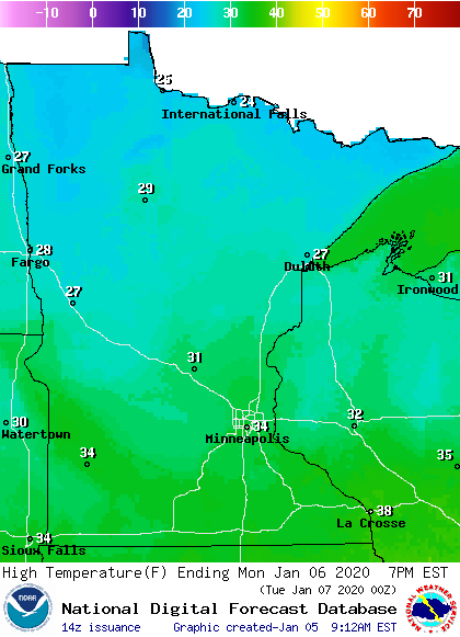
Monday highs will be in the 30s south with 20s to the north:
Tuesday highs only reach the teens in the north, with 20s south:
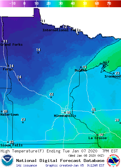
Twin Cities metro area highs are projected to be in the lower 20s on Wednesday, followed by mid 30s on Thursday, and lower 20s on Friday.
Snow depths
If you have plans to go out and play in the snow this Sunday, there’s plenty of snow cover across most of Minnesota. Here’s the Minnesota snow depth map, courtesy of the Minnesota State Climatology Office and the Minnesota Department of Natural Resources:

Snow depths range from two inches or less in far southern Minnesota to 18 to 24 inches across a wide swath of northern Minnesota. It looks there’s even a tiny spot of 24 to 30 inches in northeastern Minnesota.
Most of Minnesota has more than enough snow on the ground for cross-country skiers, sledders and snowboarders. There’s enough snow cover for snowmobiling in much of central and northern Minnesota.
Programming note
You can hear my live weather updates on MPR News at 7:35 a.m., 9:35 a.m. and 4:35 p.m. each Saturday and Sunday.

