
Windy Sunday, with a morning wintry mix in some areas
Highest winds to west
Go Deeper.
Create an account or log in to save stories.
Like this?
Thanks for liking this story! We have added it to a list of your favorite stories.


Our Sunday morning will feature some bands of precipitation at times in Minnesota and western Wisconsin. It’ll be light snow in some areas, but light freezing drizzle, light freezing rain and sleet are also possible.
This description is from the Twin Cities NWS:
Special Weather Statement National Weather Service Twin Cities/Chanhassen MN 550 AM CST Sun Jan 5 2020 MNZ044-045-050>053-059>063-068>070-WIZ014>016-023>028-051600- Mille Lacs-Kanabec-Benton-Sherburne-Isanti-Chisago-Wright- Hennepin-Anoka-Ramsey-Washington-Carver-Scott-Dakota-Polk-Barron- Rusk-St. Croix-Pierce-Dunn-Pepin-Chippewa-Eau Claire- Including the cities of Princeton, Mora, Foley, Elk River, Cambridge, Center City, Monticello, Minneapolis, Blaine, St Paul, Stillwater, Chaska, Shakopee, Hastings, Osceola, Rice Lake, Ladysmith, Hudson, River Falls, Prescott, Menomonie, Durand, Chippewa Falls, and Eau Claire 550 AM CST Sun Jan 5 2020 ...WINTRY MIX WITH LIGHT FREEZING RAIN POSSIBLE THIS MORNING... .A band of snow and light freezing rain will move across eastern Minnesota and northern Wisconsin this morning. Accumulations will be light, but could be enough to cause slick spots on roads. Use caution while driving, especially if the roads are icy.
There have been some reports of sleet in the Twin Cities metro area this morning.
You can hear updated weather information on the MPR network, and you’ll see updated weather info on the MPR News live weather blog.
Turn Up Your Support
MPR News helps you turn down the noise and build shared understanding. Turn up your support for this public resource and keep trusted journalism accessible to all.
The Minnesota Department of Transportation will have reports on road conditions. Wisconsin road conditions can be found here.
Winds
And it’ll be windy. Wind advisories cover most of Minnesota and far western Wisconsin this Sunday:

Details on the metro area portion of the wind advisory:
URGENT - WEATHER MESSAGE National Weather Service Twin Cities/Chanhassen MN 250 AM CST Sun Jan 5 2020 MNZ043>045-050>053-059>063-068>070-076-077-083-084-051700- /O.EXT.KMPX.WI.Y.0001.200105T1300Z-200105T2200Z/ Morrison-Mille Lacs-Kanabec-Benton-Sherburne-Isanti-Chisago- Wright-Hennepin-Anoka-Ramsey-Washington-Carver-Scott-Dakota- Le Sueur-Rice-Blue Earth-Waseca- Including the cities of Little Falls, Princeton, Mora, Foley, Elk River, Cambridge, Center City, Monticello, Minneapolis, Blaine, St Paul, Stillwater, Chaska, Shakopee, Hastings, Le Sueur, Faribault, Mankato, and Waseca 250 AM CST Sun Jan 5 2020 ...WIND ADVISORY NOW IN EFFECT FROM 7 AM THIS MORNING TO 4 PM CST THIS AFTERNOON... * WHAT...Northwest winds 30 to 35 mph with gusts up to 50 mph expected. * WHERE...Portions of central, east central and south central Minnesota. * WHEN...From 7 AM this morning to 4 PM CST this afternoon. The strongest winds will occur after 10 AM. * IMPACTS...Gusty winds could blow around unsecured objects. Tree limbs could be blown down and a few power outages may result. PRECAUTIONARY/PREPAREDNESS ACTIONS... Use extra caution when driving, especially if operating a high profile vehicle. Secure outdoor objects.
A high wind warning includes northwestern Minnesota counties along the Red River this morning, then it becomes a wind advisory. Morning wind gusts may reach 65 mph in that area..
Temperature trends
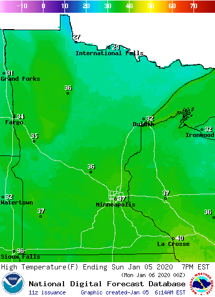
Our average high temp is 24 degrees in the Twin Cities metro area this time of year. We’re looking at a Sunday afternoon high in the upper 30s in the metro area.
Sunday highs reach the 30s across most of Minnesota and western Wisconsin:
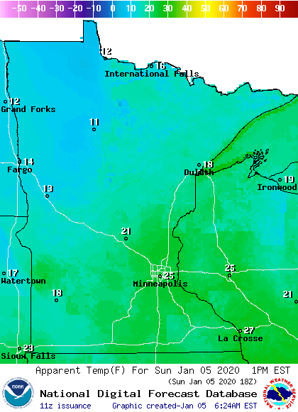
The strong winds will create afternoon wind chill temps in the teens north and west, with 20s southeast and in western Wisconsin:
An updated Updraft will be posted around mid-morning.
Programming note
You can hear my live weather updates on MPR News at 7:35 a.m., 9:35 a.m. and 4:35 p.m. each Saturday and Sunday.

