
Wild temperature swings grip Minnesota through the weekend
Snow chances remain light
Go Deeper.
Create an account or log in to save stories.
Like this?
Thanks for liking this story! We have added it to a list of your favorite stories.


Temperatures will swing dramatically over the next few days, ranging from subzero lows to highs in the 40s. Snow chances stay fairly limited, but a couple different rounds of snow are possible.
Tuesday’s cold front
The cold front has already sliced through northern Minnesota as of Tuesday morning and will be entirely through the state by early afternoon.
Because of this, high temperatures were already set early Tuesday morning. Most of northern Minnesota will see falling temperatures all day. Here is an example of that downward trend for Duluth on Tuesday (followed by rising temperatures into Thursday):

Southern Minnesota sees temperatures that may hold fairly steady in the morning, then fall by afternoon. Here are the expected temperatures across the state at 4 p.m.:
Turn Up Your Support
MPR News helps you turn down the noise and build shared understanding. Turn up your support for this public resource and keep trusted journalism accessible to all.

Temperatures dive through Wednesday morning, at which point temperatures will range from the negative teens in northern Minnesota to southern Minnesota clinging to the low single digits.

Wind chills overnight could exceed minus 20 for northern parts of the state.
Snow chances stay limited as the front passes through, with most places seeing only a chance for flurries. Southern Minnesota could see a light dusting of snow in the afternoon.

Winds are also picking up as the front moves through. Northern Minnesota already has winds gusting near 30 mph as of Tuesday morning, and most of the state will see windy conditions by afternoon.

Temperature roller coaster
After a frigid start Wednesday morning, temperatures immediately start rising again. Thanks to warm air ahead of the next weather system, temperatures keep increasing overnight Wednesday into Thursday. All of Minnesota makes it back to average temperatures by Thursday, with southern Minnesota well above average, including some highs in the 40s.
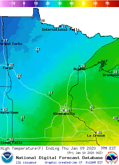
Cooler air pushes across the state again Friday, and it will likely be another day where most of the highs are set at the start of the day. Then we may see steady or falling temperatures through Friday and into Saturday morning, with many temperatures Saturday morning starting subzero again.
Precipitation chances through the weekend
While the next storm systems may cause dramatic temperatures changes, they do not bring significant moisture. The same system that warms the state into Thursday will also bring snow to northern Minnesota by Wednesday evening. Precipitation will be more widespread Thursday, and any part of the state could see flurries or light snow. Southern Minnesota may also see a little light rain.
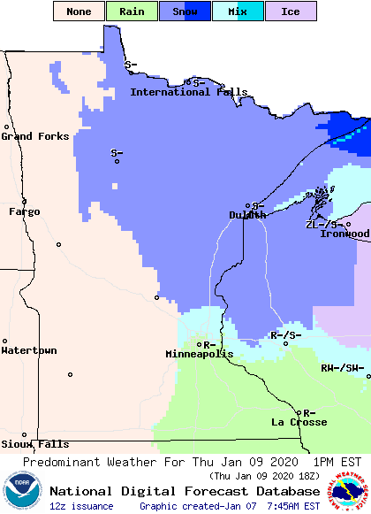
Snow accumulation will likely be confined to northern Minnesota, with a possible 1 to 3 inches.
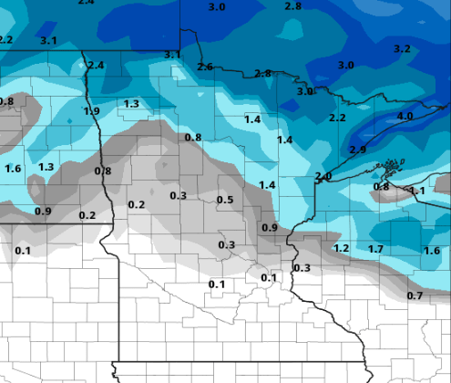
Everything moves out by Thursday evening.
There is another chance for light snow to move across the state on Sunday. Currently It looks like most places would see less than an inch of snow.
Programming note
You can hear my live weather updates on Minnesota Public Radio at 7:48 a.m. Monday through Friday morning.

