
Snow returns Sunday afternoon/evening; milder temps today
Lake-effect snow up north
Go Deeper.
Create an account or log in to save stories.
Like this?
Thanks for liking this story! We have added it to a list of your favorite stories.


Here’s a quick morning briefing.
Lake-effect snow continues today near Lake Superior:

A winter storm warning continues until 4 p.m. this Sunday along portions of the North Shore of Lake Superior:
URGENT - WINTER WEATHER MESSAGE National Weather Service Duluth MN 602 AM CST Sun Jan 12 2020 ...HEAVY LAKE EFFECT SNOW AFFECTING THE NORTH SHORE TODAY... .The heavy lake effect snow continues along the North Shore this morning, and will continue to gradually lift northward today as winds turn more east to southeasterly, impacting the North Shore as far north as Lutsen and Tofte this afternoon. Current radar imagery shows a fairly intense band of lake effect snow forming over Two Harbors this morning. Due to the possibility of locally heavier snowfall amounts, decided to extend the Winter Storm Warning for southern Lake county into the afternoon hours today. Additional snowfall accumulations of between 2 to 5 inches are expected, with some locally higher amounts possible if a more intense band of lake effect snow develops. MNZ020-122200- /O.EXT.KDLH.WS.W.0001.000000T0000Z-200112T2200Z/ Southern Lake- Including the cities of Two Harbors and Silver Bay 602 AM CST Sun Jan 12 2020 ...WINTER STORM WARNING NOW IN EFFECT UNTIL 4 PM CST THIS AFTERNOON... * WHAT...Heavy lake effect snow. Additional snow accumulations of between 2 to 5 inches will be possible for areas of southern Lake county, with some locally heavier amounts possible. * WHERE...In Wisconsin, Douglas County. In Minnesota, Southern Lake and Carlton and South St. Louis Counties. This includes the Tribal Lands of the Fond du Lac Band. * WHEN...Until 4 PM CST this afternoon. * IMPACTS...Plan on slippery road conditions, and reduced visibility at times. PRECAUTIONARY/PREPAREDNESS ACTIONS... If you must travel, keep an extra flashlight, food, and water in your vehicle in case of an emergency. The latest road conditions can be obtained by calling 5 1 1. Road conditions can also be found at 511mn.org for Minnesota or 511wi.gov for Wisconsin.
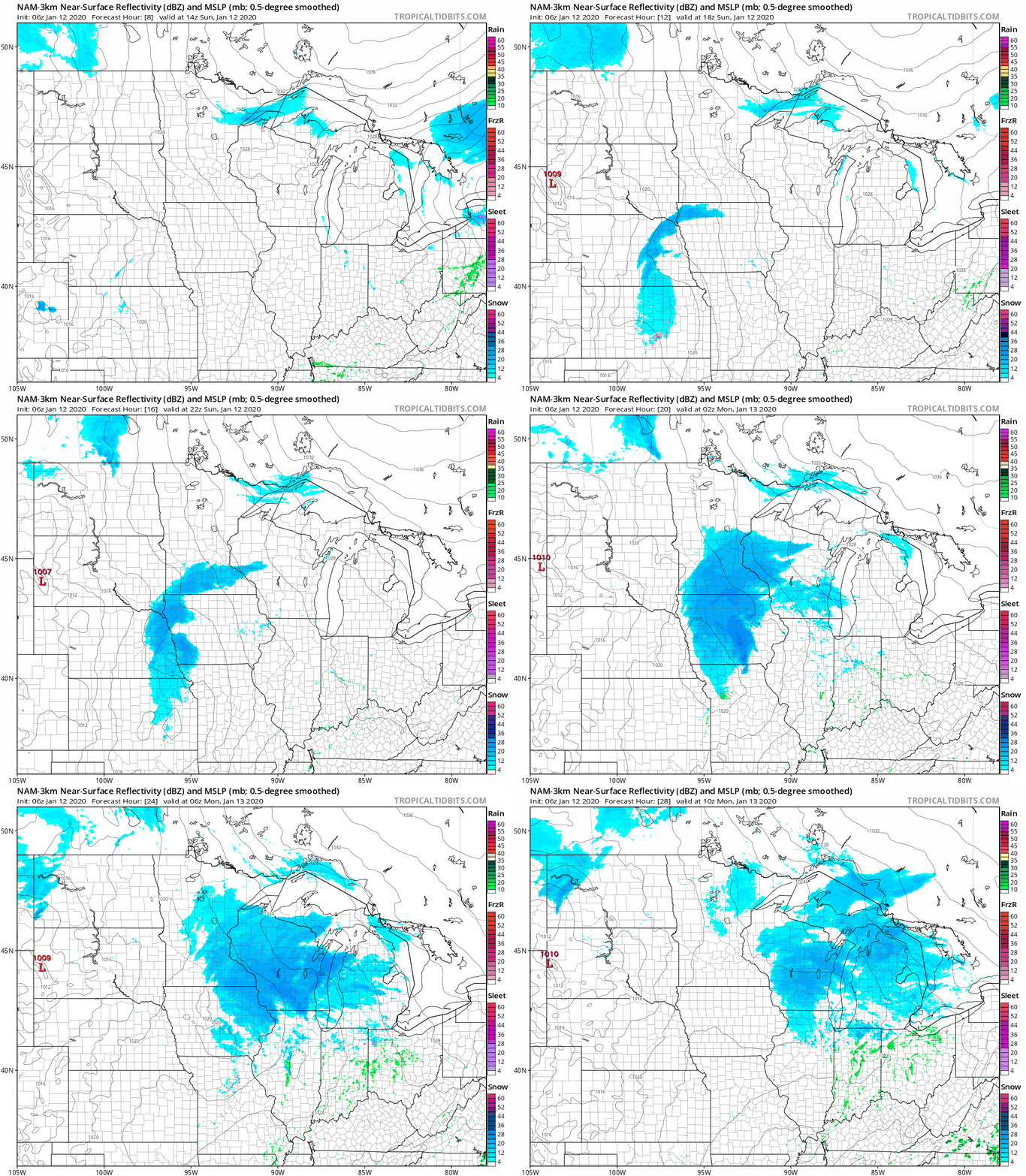
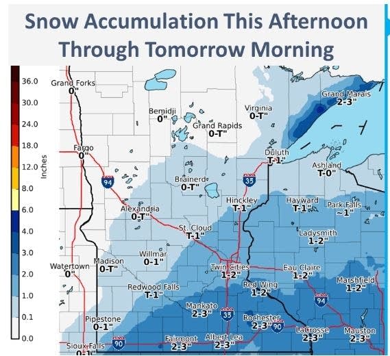
Snow will move into southern Minnesota Sunday afternoon and spread northeastward through the late afternoon and evening hours. It looks like the snow will arrive in the Twin Cities metro area in the mid to late afternoon hours and continue Sunday evening, with an inch or two of accumulation possible. Some spots in southeastern Minnesota could see around three inches of snow.
Turn Up Your Support
MPR News helps you turn down the noise and build shared understanding. Turn up your support for this public resource and keep trusted journalism accessible to all.
The National Oceanic and Atmospheric Administration’s North American Mesoscale forecast model shows the potential precipitation pattern Sunday through Sunday night:
Snow amounts from this one will be highest to the southeast:
You can hear updated weather information on the MPR network, and you’ll see updated weather info on the MPR News live weather blog.
Temps rebound
Sunday afternoon highs reach the teens in northern and central Minnesota, with 20s from southern Minnesota into Wisconsin:
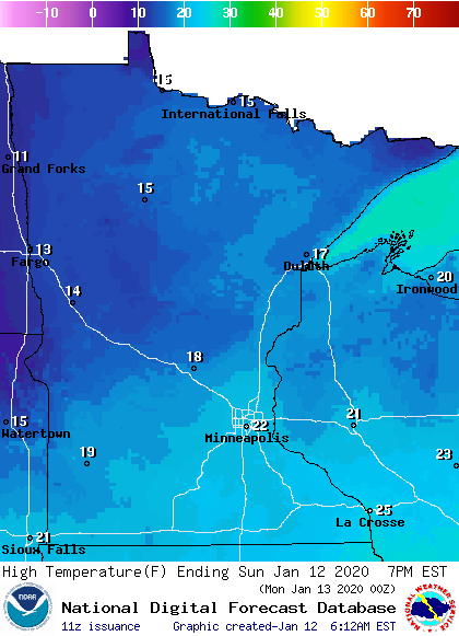
Metro area highs reach the low to mid 20s Sunday afternoon.
An updated Updraft blog will be posted before 10 a.m.
Programming note
You can hear my live weather updates on MPR News at 7:35 a.m., 9:35 a.m. and 4:35 p.m. each Saturday and Sunday.

