
Arctic chill on Sunday, with light snow to the north
January thaw arrives midweek
Go Deeper.
Create an account or log in to save stories.
Like this?
Thanks for liking this story! We have added it to a list of your favorite stories.


The temperature at Minneapolis-St. Paul International Airport was 26 degrees at 8 a.m. Saturday. The temp dropped sharply over the next few hours, reaching 15 degrees at 10 a.m. and 9 degrees at 1 p.m. as winds really ramped up. I felt a bit of brain-freeze as I walked into the wind Saturday afternoon.
There’ll be enough wind Saturday evening into Sunday morning for some very cold wind chill temps. Wind chill advisories begin at midnight Saturday night in parts of the Twin Cities metro area and western Wisconsin, and run to 9 a.m. Sunday:
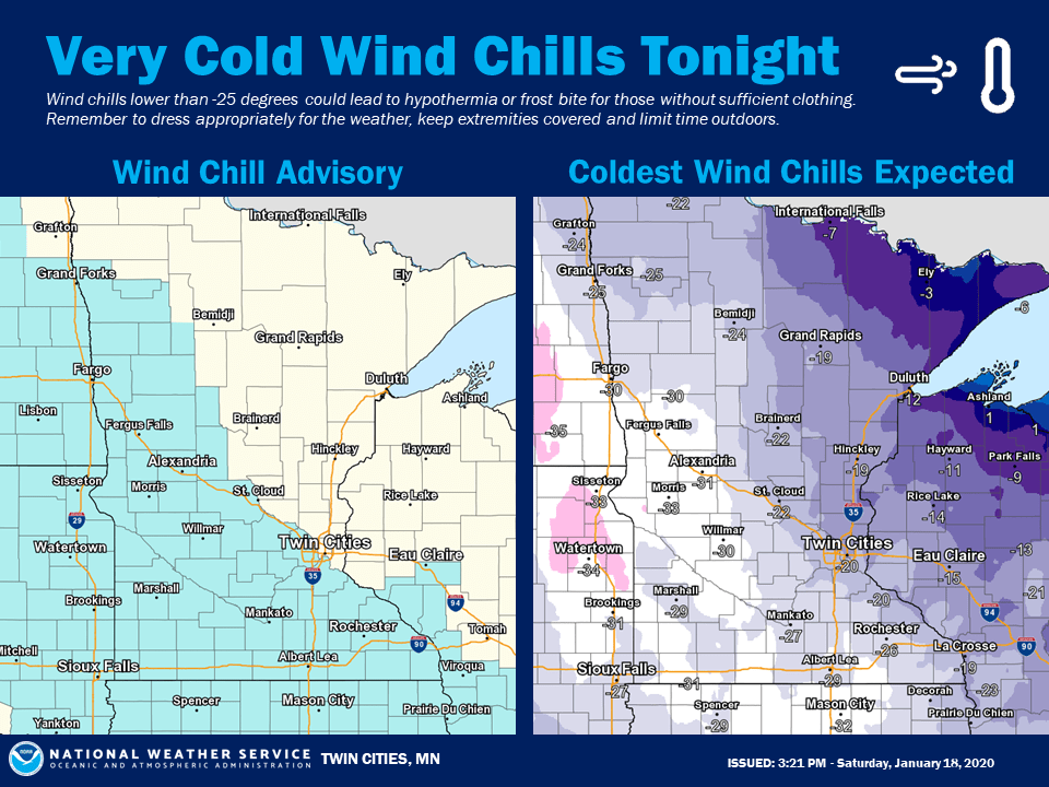
”Tonight” in the graphic refers to Saturday night. The metro area could see wind chills of -20 to -25 at times. Wind chill advisories begin Saturday evening in portions of western Minnesota and run through noon on Sunday. Some areas in western Minnesota could see wind chills of -30 or lower at times.
You can hear updated weather information on the MPR network, and you’ll see updated weather info on the MPR News live weather blog.
Turn Up Your Support
MPR News helps you turn down the noise and build shared understanding. Turn up your support for this public resource and keep trusted journalism accessible to all.
Some roads are still slick due to our recent snow plus the very cold temps. The Minnesota Department of Transportation will have reports on road conditions. Wisconsin road conditions can be found here.
Temperature trends
Sunday highs will be in the single digits in most locations:
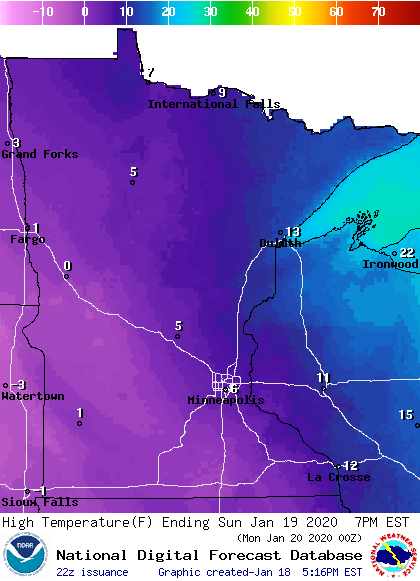
That’s cold! Our average Twin Cities metro area high temp is 23 degrees this time of year.
Wind chills ease a bit Sunday afternoon in eastern Minnesota and western Wisconsin, but they will still be well below zero:
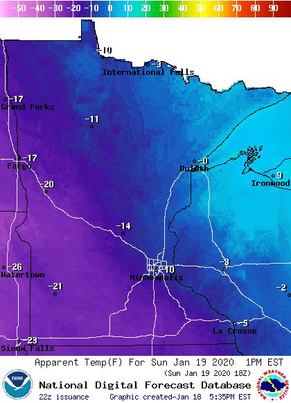
Twin Cities metro area highs are projected to be in the lower teens on Monday, followed by around 20 degrees on Tuesday. Our January thaw arrives on Wednesday, with a high in the mid 30s, which will be followed by highs in the upper 30s Thursday and lower 30s on Friday.
Snow chances
An additional inch or two of snow is possible in portions of Lake and Cook counties of northeastern Minnesota Saturday evening.
Parts of northwestern Wisconsin and the upper peninsula of Michigan will see accumulating snow overnight Saturday night into Sunday:
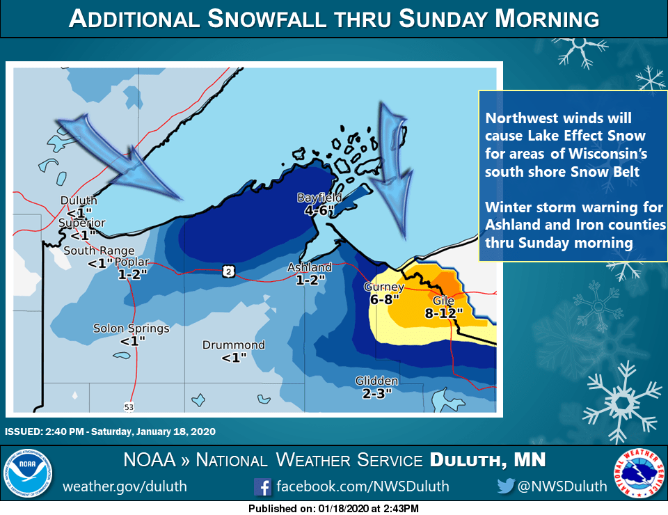
Some snow is expected to move into portions of northern Minnesota Sunday p.m., and the Twin Cities metro area could see some light snow or flurries Sunday evening.
The National Oceanic and Atmospheric Administration’s North American Mesoscale forecast model shows the potential precipitation pattern this Saturday evening through Sunday evening:
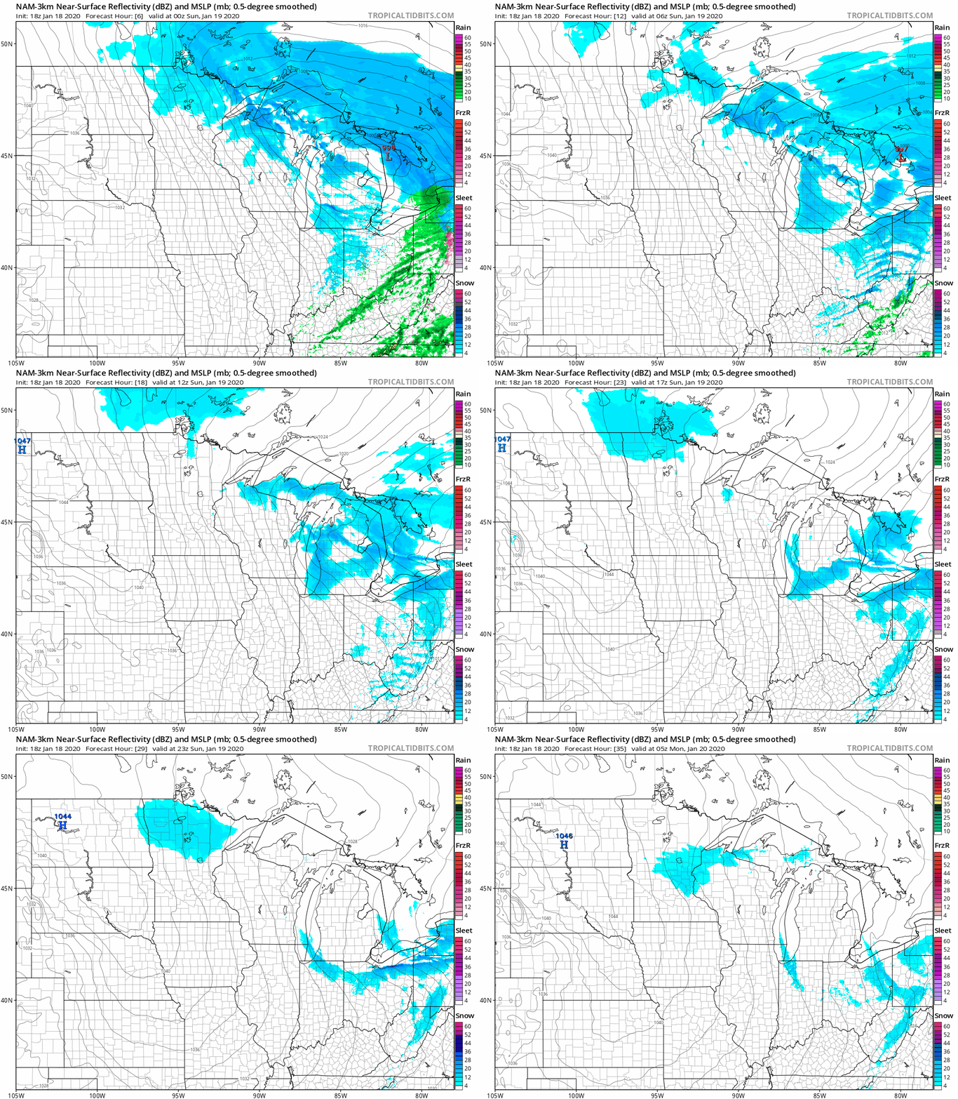
Light snow showers or flurries could linger over parts of eastern Minnesota and western Wisconsin Monday morning. The Twin Cities metro area might have a bit of snow or a wintry mix late Wednesday and on Thursday, but no big snowstorms are in sight.
Storm totals
The Friday/Friday night snow total at MSP airport was 4.9 inches. I saw a report of 5.8 inches in Richfield. You can generate an updated snow report map here. Just hover over any location on the map at that link to get the location, snow total and time of the snow measurement. Move the slider in the upper left corner of the linked map to “48 hours” to include reports from earlier on Friday.
Here’s how the Friday/Saturday snow report map looked on Saturday:

You can see some higher snow totals in southwestern Minnesota.
A wedge of dry air Friday night lowered our snow totals in the Twin Cities metro area and parts of central Minnesota, but I won’t complain about shoveling less snow!
There were some double-digit snow totals in parts of northeastern Minnesota, especially along and near the North Shore of Lake Superior from Two Harbors to Grand Marais:

Northern Minnesota and northwestern Wisconsin snow reports can be found here.
Programming note
You can hear my live weather updates on MPR News at 7:35 a.m., 9:35 a.m. and 4:35 p.m. each Saturday and Sunday.

