
Fierce winds cause whiteout conditions in parts of western Minn. and far southern Minn.
Temperatures plummet Saturday afternoon
Go Deeper.
Create an account or log in to save stories.
Like this?
Thanks for liking this story! We have added it to a list of your favorite stories.


Fierce winds will cause blowing and drifting snow and severely reduced visibilities this Saturday across portions of western Minnesota and far southern Minnesota.
Conditions can change rapidly in open areas:
Additional snow amounts this weekend will be light in most areas, but higher amounts are expected in northeastern Minnesota and northwestern Wisconsin:

Northeastern Minnesota has already seen some very impressive snow amounts since Friday afternoon:
Turn Up Your Support
MPR News helps you turn down the noise and build shared understanding. Turn up your support for this public resource and keep trusted journalism accessible to all.
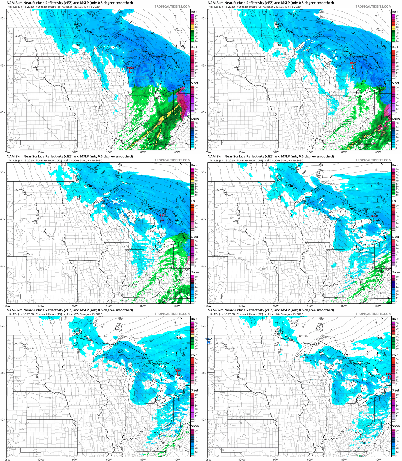
The National Oceanic and Atmospheric Administration’s North American Mesoscale forecast model shows the potential precipitation pattern this Saturday afternoon through Saturday night:
Warnings
A blizzard warning continues this Saturday in much of western Minnesota and portions of southern Minnesota, with a winter storm warning continuing in the remainder of Minnesota (except Houston county in the southeast), plus much of western Wisconsin:
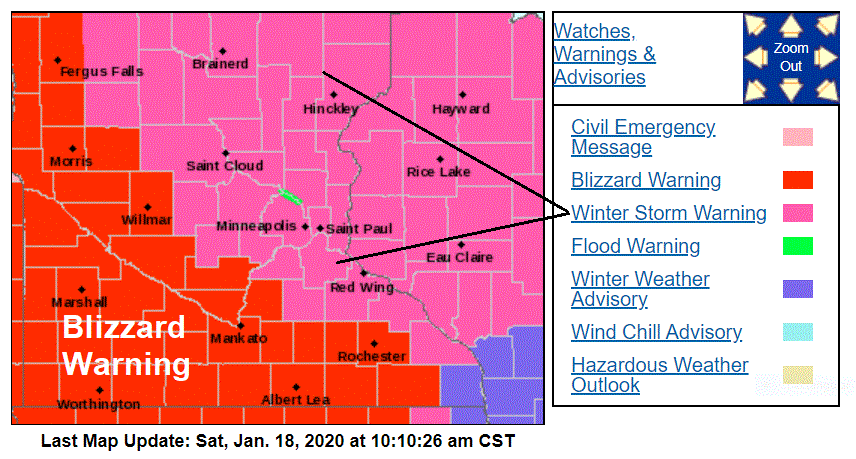
The Twin Cities metro area will see less than one-half-inch of additional snow this afternoon, but strong winds and periods of blowing and drifting snow are expected. Winds could gust over 40 mph at times this afternoon, resulting in severely reduced visibilities at times in open areas. Wind chill temps may also drop to 20 below zero or lower by mid to late afternoon. Many roads will remain slippery as the temperature plummets.
Portions of southeastern Minnesota were added to the blizzard warning around mid-morning:
URGENT - WINTER WEATHER MESSAGE National Weather Service La Crosse WI 905 AM CST Sat Jan 18 2020 ...Blizzard Conditions Developing for Portions of Southeast Minnesota and Northeast Iowa... Periods of light snow will continue into the afternoon, with little additional accumulation. Strong and gusty northwest winds will develop over the entire area by early afternoon, leading to blowing and drifting snow. Blizzard conditions are likely for the open and unsheltered areas of northeast Iowa and southeast Minnesota. If traveling, especially across southern Minnesota and northern Iowa, be prepared for dangerous whiteout conditions at times. In addition, rapidly falling temperatures will allow for any wet roads to freeze quickly this afternoon.
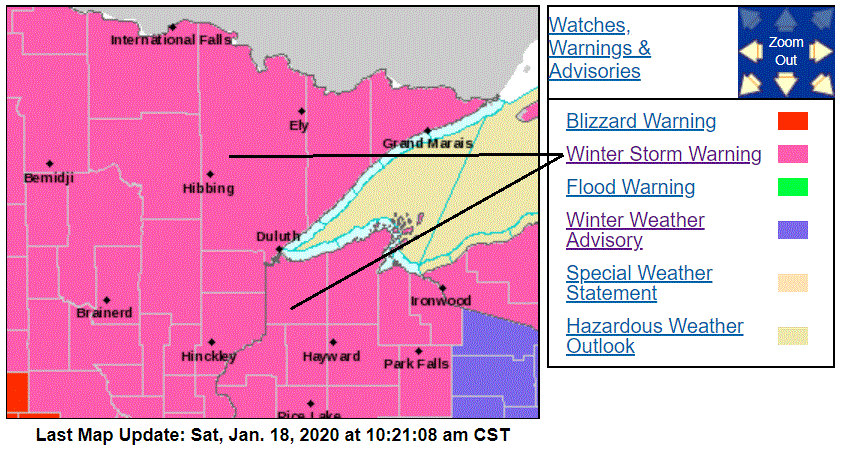
Northeastern Minnesota and northwestern Wisconsin remain in a winter storm warning:
Blizzard warnings continue through Saturday afternoon for Minnesota counties along the Red River:
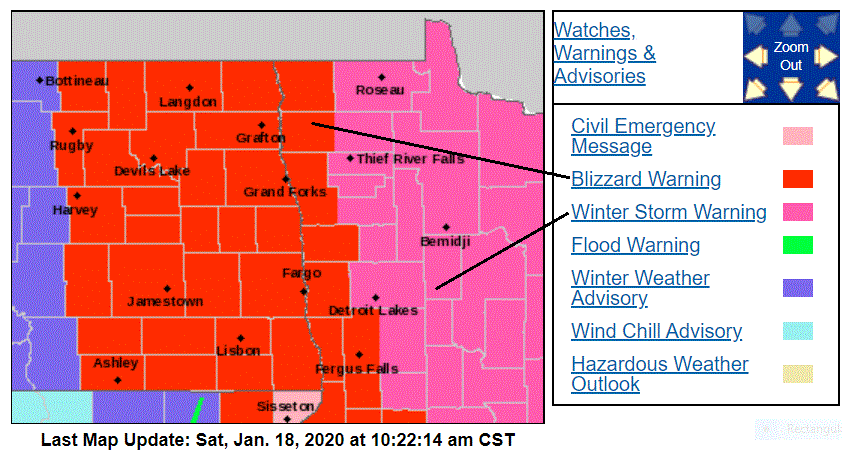
Winds could gust to 55 mph at times in western Minnesota.
You can hear updated weather information on the MPR network, and you’ll see updated weather info on the MPR News live weather blog.
The Minnesota Department of Transportation will have reports on road conditions. Wisconsin road conditions can be found here.
Updates on the winter storm will be posted by the NWS offices in the Twin Cities, Duluth, Grand Forks, La Crosse and Sioux Falls.
Snow totals
The Friday/Friday night snow total at Minneapolis-St. Paul International Airport was 4.9 inches. You can generate an updated snow report map here. Northern Minnesota and northwestern Wisconsin amounts can be found here. Just hover over any location on the map at those links to get the location and time of the snow measurement. Move the slider in the upper left corner of the linked map to “48 hours” to include reports from earlier on Friday.
Temperature trends
Our Saturday highs happened in the morning, with falling temps expected this afternoon. Wind chills will become much colder as the temps drop and our winds pick up. Wind chills in the 20s below zero are expected across much of western Minnesota and portions of central and southern Minnesota Saturday afternoon.
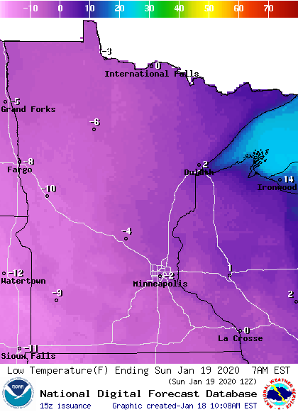
Sunday morning low temps are below zero:
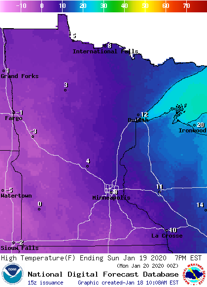
Sunday highs only reach the single-digits above zero:
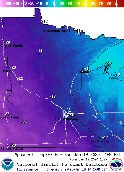
Sunday afternoon wind chill temperatures are well below zero:
Our average Twin Cities high temp is 23 degrees this time of year. Twin Cities highs are projected to reach the lower teens on Monday, followed by around 20 degrees on Tuesday . Then we see milder highs; reaching the mid 30s Wednesday, upper 30s Thursday and lower 30s on Friday. that’s a nice January thaw!
Programming note
You can hear my live weather updates on MPR News at 7:35 a.m., 9:35 a.m. and 4:35 p.m. each Saturday and Sunday.

