
Light snow and ice Thursday, followed by potential record warmth
Some sunshine returns for the weekend
Go Deeper.
Create an account or log in to save stories.
Like this?
Thanks for liking this story! We have added it to a list of your favorite stories.


Snow and light freezing drizzle will spread across Minnesota Thursday and linger into mid-Friday. By the weekend, a big warm-up takes hold and more sunshine returns.
Thursday and Friday
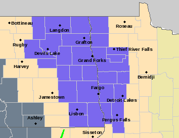
An area of low pressure will be moving across Minnesota through Friday, bringing in warmer air aloft and light precipitation. As it spreads through northwestern Minnesota Thursday morning, the area is under a Winter Weather Advisory until noon due to freezing drizzle potential.
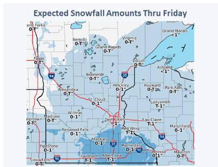
It is because of the mild air aloft that some of the precipitation will be freezing drizzle, along with light snow. Little to no ice is expected to accumulate, and snow will remain under one inch for most of the state.
The mixed precipitation spreads across Minnesota by Thursday evening.
Turn Up Your Support
MPR News helps you turn down the noise and build shared understanding. Turn up your support for this public resource and keep trusted journalism accessible to all.
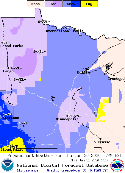
It will move out for most of the state by early Friday afternoon. For the Twin Cities, there is a slight chance for light snow or ice for the Thursday evening commute, and possible light snow for Friday morning.
Northwestern Minnesota will be out of the precipitation already by early Friday but will likely see areas of fog through the morning.
Skies will remain cloudy again on Thursday and mostly cloudy Friday.
Temperatures
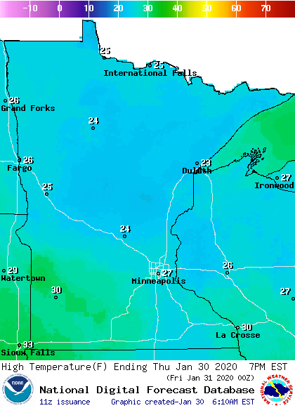
Thursday’s high temperatures will be slightly above average, in the 20s and low 30s.
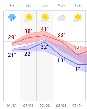
Temperatures warm a little more Friday, but weekend will be when our big thaw happens. All of Minnesota is likely to be in the 30s by Saturday, and most of the state sees highs near or above 40 on Sunday. Here is the temperature trend for Bemidji, with highs in red and lows in blue, showing how the warmth extends even into northern Minnesota:
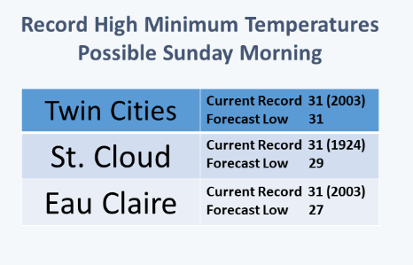
The best chance for record warmth comes Sunday morning, when some of the lows could be near “record high minimums,” meaning the low temperatures could be the warmest on record.
However, the warm-up is brief. By Tuesday most of the state will be back at or slightly below average, with highs in only the teens and 20s.
Upcoming weather
Right now, there are no major storms in sight for the week ahead, with only minor chances for light snow. We could see some more foggy mornings though, especially from the extra moisture with some of the snow-pack melting over the weekend when temperatures are warm.
On a brighter note, we should finally be seeing a bit more sunshine over the weekend!
Programming note
You can hear my live weather updates on Minnesota Public Radio at 7:48 a.m. Monday through Friday morning.

